Drift Bottle Found on Martha’s Vineyard Has Quite a Story to Tell
Keith Moreis likes to walk the beaches of Martha’s Vineyard, often finding pieces of sea glass. Occasionally he finds other treasures. On December 22, 2013, during a routine walk on Long Point Reservation in West Tisbury, he found a glass bottle resting in the sand next to some seagrass. After brushing aside the sand, he was surprised to see that the bottle was intact.
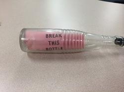
Drift bottle found on Martha’s Vineyard
The clear glass soda bottle, about 8 inches tall, had a black stopper on top and contained some papers. Inside the bottle, a pink sheet printed with the words “Break This Bottle” caught his attention. He took the bottle home.
Intrigued by the message and not wanting to break the bottle, Moreis managed to get the black top off with a corkscrew. It was not easy. With a wire, he pulled out the pink sheet and a postcard with printing on both sides. One side of the postcard had an address; the other side had instructions to the finder and some stamped and handwritten information.
Moreis, who was born and raised on Martha’s Vineyard, remained curious about the bottle and its contents and showed it to friends, who suggested he bring it to Woods Hole to see if anyone knew about it. On February 20 he went to the Woods Hole Oceanographic Institution (WHOI), which had reported finding another drift bottle a few weeks earlier. Since the postcard had Coast and Geodetic Survey, Department of Commerce in the return address, WHOI staff suggested that Moreis contact oceanographer Jim Manning at the Woods Hole Laboratory of NOAA’s Northeast Fisheries Science Center (NEFSC). He did, and brought the bottle to the Center later that day.
Both sides of a sample postcard placed inside Coast and Geodetic Survey drift bottles. When released, the ship’s name, location and date of release, and the bottle number were stamped or handwritten on the card. Photo credit: NOAA.
The postcard had both stamped and handwritten information on the top: U.S.C.&G.S. HYDROGRAPHER was stamped on the left corner, and Sep 19, 1959 on the right corner, with the day handwritten. In the middle, just above the printed words “FINDER OF THIS BOTTLE” and instructions below, was the handwritten number 279B, written twice.
USCGS refers to the U.S. Coast and Geodetic Survey. The U.S. Coast Survey, created by President Thomas Jefferson in 1807 as the Survey of the Coast, expanded as the nation grew westward to include surveys of the interior of the country. The agency was renamed the U.S. Coast and Geodetic Survey in 1878. Today it is known as the National Geodetic Survey and has been part of the National Oceanic and Atmospheric Administration (NOAA) since NOAA was created in 1970 in the Department of Commerce.
Manning reviewed copies of drift bottle records through 1958 published by the Fish and Wildlife Service and compiled by Dean Bumpus of WHOI. However, the release date for this bottle was 1959 and therefore was not in these records. A trip by Manning to the WHOI Data Library and Archive a few days later uncovered more information about drift bottles released by the ship Hydrographer during Coast and Geodetic Survey (USC&GS) surveys. Bumpus had asked other agencies, including the Coast and Geodetic Survey in late 1959, to provide him with copies of their drift bottle data.
This sheet was also inside the drift bottles. A faded sheet is visible in the bottle pictured above found in December 2013. Photo credit: NOAA.
In February 2014, Albert “Skip” Theberge at the NOAA Central Library had also contacted the NEFSC regarding another drift bottle story. After sharing news of this latest bottle find with him, the NEFSC asked Theberge about drift bottle releases by USC&GS ships. Drift bottles had been in use by the Coast and Geodetic Survey to track ocean currents since 1846. The last drift bottles used by the survey were released between 1958 and 1966.
It did not take long to locate information from the Coast and Geodetic Ship Explorer in the Pacific Ocean in the 1950s, and about Explorer cruises in the Atlantic Ocean. However, there were no images related to drift bottles releases from the Hydrographer. But there was something else of interest: An image of a postcard from drift bottle 17465, found 25 miles south of Nelson Lagoon in southwest Alaska on February 8, 2011.
The image caption read: “Perhaps the last drift bottle that will ever be found. All drift bottle records have been closed for years so the exact location and even ship that launched Drift Bottle 17465 is unknown. It is probable that it was launched from either the EXPLORER or PATHFINDER in the 1950’s or 1960’s. It is remarkable that the bottle survived for close to fifty years.”
As for the last drift bottle from Coast and Geodetic Surveys to be found, the bottle found by Keith Moreis on Martha’s Vineyard may now hold the record.
In the meantime, archive documents revealed that in September and October of 1959 the USC&GS Ship Hydrographer conducted environmental studies in three areas off the New England Coast: 16 miles northeast of Cape Cod Light, just south of Nomans Land, and 36 miles south of Gay Head on Martha’s Vineyard.
A detailed hydrographic survey had been conducted in each area. In addition to collecting bottom sediment samples and biological dredge hauls, the Hydrographer had obtained 100 hours of current meter measurements made at the surface, mid-depth and near the bottom with current meters suspended from anchored buoys. Drift bottles were released at each buoy station at the rate of six per hour, all six with the same bottle number, for the 100 hours of current measurements.
The bottle releases were part of a study of ocean currents and the drift of floating objects off the New England coast. They were also part of a study to determine currents in the vicinity of proposed offshore atomic waste dumping sites.
As of February 8, 1960, only two drift bottle cards had been returned from the area 36 miles south of Gay Head (now known as Aquinnah), but nearly 60 percent from the area just south of Nomans Land. Approximately 5 percent of bottle card returns came from the area 16 miles northeast of Cape Cod Light, now known as Highland Light, in Truro.
Records as of March 1960 indicate that four of the six bottles numbered 279B released south of Nomans Land were recovered within two months of their September 19, 1959 release: one after 2 days, another after 4 days, and a third after 7 days. All three were found on Martha’s Vineyard. The fourth was found after 55 days on Nantucket.
The December 2013 bottle is one of the last two bottles released in that group. Like the others, it was recovered just miles away from where it began its journey, but in this case more than 54 years later.
For Keith Moreis, that December beach walk on a cold winter day yielded a treasure indeed.
“Finding the bottle was exciting,” said Moreis. “Learning more about it and its history has been a rewarding experience, to say the least. I never expected to find something like this, but then again, you never know what you will find on the beach.”