December 2018 Alabama River Bass
with Cole Burdeshaw
Big spotted bass actively feeding on river points and bluff banks. Quality largemouth looking for something to eat around creek grass beds and blowdowns. The Alabama River has both this month and offers you options for catching them.
The River, as locals call it, also goes by Woodruff Lake or Jones Bluff and runs right by the amphitheater in Montgomery. It starts where the Coosa and Tallapoosa Rivers join near Wetumpka and runs 80 miles west to its lock and dam. It is full of Coosa spots but also has a good population of largemouth.
Cole Burdeshaw lives in Headland and helped start the high school fishing team there. He is a senior on the Auburn fishing team now but also fishes many pot and local tournaments. He won the Alabama Nation adult division Federation State Championship tournament on Eufaula in October this year.
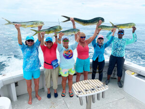
In September he teamed up with Peyton McCord, also from Headland and on the Auburn team, to fish the Reel Money Team Trail Championship on the Alabama River. They won with ten bass weighing 29.14 pounds, taking home $10,000 first prize. He knows how to catch bass on the river.
“The Alabama River may be the most underappreciated fishery in this area, or even the state.” Cole said. There have been big tournaments here like BASS Elite and Open tournaments, FLW, Alabama Bass Trail and the Reel Money Championship and they show how good the fishing can be, but it just does not get the publicity of other fisheries.
The Alabama Bass Anglers Information Team tournament results back this up. In pounds per angler day the Alabama River ranks ahead of well-known Eufaula and Guntersville. In bass per angler it ranks above those two and Pickwick.
By late November, most of the spots on the upper end of the river have set up on the main channel. Those are the ones Cole targets in tournaments, since their average size is better and there are many more of them. But some big largemouth are in the creeks feeding and one of them goes a long way when you need a kicker.
For December spots, Cole will have a jerkbait, jig and pig and crankbait ready to cast. When looking for a kicker largemouth he chooses a swim jig and spinnerbait.
The day before Halloween Cole and Peyton showed me how they won the Reel Money Championship and places they will be fishing in December. Some of them are the same places they won the championship since bass hold on them all year. Some of them get better and better as the water cools.
They fished a little different in September than they will be fishing in December. Most of their winning fish hit topwater and fast moving jerkbaits. This month topwater may still draw a few bites, and it is a good idea to try them, but jerkbaits and crankbaits fished slowly, and a jig and pig, will get more bites in the colder water.
1. N 32 25.582 – W 86 23.268 – Across from Cooters Pond, going upstream about a half mile, power lines cross the river. Just downstream of them on the right bank going upstream, a small ditch enters the lake. This is one of the kinds of places Cole targets in December.
Cole calls these places “U-ins” since they show a small indention on maps. Runoff in these places often build up a small delta, forming a point that breaks the current. This one and most others have blowdowns and wood cover on them, especially on the banks on both sides, offering more feeding places.
Stop downstream of the downstream point with your boat in about 25 feet of water and cast a jerkbait near the bank in the ditch. Work it back slowly, with a jerk-pause or jerk-jerk-pause. Make the pauses longer the colder the water. Work the jerkbait faster at the beginning of the month and slower later in
December. Also work a crankbait in the same areas, and drag a jig and pig through it.
After fishing the mouth of the ditch work the wood cover on both sides. Since so many released bass at Cooters Pond move to this area, Cole will fish the wood all the way from the ditch almost down to directly across from Cooters Pond. Work a jerkbait over the trees, bump a squarebill through them and bump limbs with a jig and pig.
2. N 32 22.557 – W 86 27.814 – Run down to the mouth of Catoma Creek on the left side going downstream. The mouth of it has a good point for spots and the
creek has grass beds and blowdowns that hold good largemouth. This is about as far downstream as Cole goes and it is his target when looking for a kicker largemouth.
Stop out in the middle of the mouth and cast over the downstream point with jerkbait and crankbait. It is gravel and clay, an ideal bottom for spots. A sexy shad or chartreuse sexy shad 5XD will bump the bottom, which it must do for consistent bites.
On the upstream point there is a good grassbed to fish. The water around it is shallow but the river channel is not far away. It was completely out of the water when we were there but the water was unusually low. Cast a three eights ounce chartreuse War Eagle spinnerbait with a silver and a gold willowleaf blade into the grass and work it out, looking like a baitfish coming out of the grass.
Swim a dirty white one quarter to three eights ounce Dirty Jig swimjig in to the grass and fish it out. If the water is high, cast back into the grass as far as you can work the jig.
Go into the creek and fish other grassbeds the same way. Try the spinnerbait and swim jig in blowdowns, especially on outside bends of the creek. Bump a jig and pig through the limbs of the trees before leaving. You could spend all day fishing for largemouth in Catoma Creek and have a decent catch, but you will catch a lot more fish out on the river.
3. N 32 24.070 – W 86 26.643 – Back upstream around the bend where the substation sits in the water, where the river straightens back out, a ditch enters the river where a big pasture starts up on the bank. The delta of this creek runs a little upstream from the downstream point and there are stumps on it that are key to fishing here. Blowdowns are on both sides of the creek.
When current is moving across this point and others Cole picks up his 5XD first. In slack water he starts with a jerkbait. Work both cross the whole mouth of the ditch. Then bump through the stumps with a jig and pig.
Cole fishes a three eights to one half ounce green pumpkin War Eagle jig with a tilapia Fighting Frog trailer. Use the heavier jig in stronger current. Cole says the Fighting Frog is by far the best trailer he has tried
.
4. N 32 24.748 – W 86 24.230 – Go under the Highway 31 bridges and stop on the small creek on the left just above it. This water is usually clearer, probably from a spring, and can be a little warmer in December, making the fish a little more active. It is always flowing.
The point here is sand and gravel and holds spots. Keep your boat in 25 plus feet of water and cover the area with all your baits. It is important to keep your boat outside the point. Don’t get closer than where the bottom starts to come up, around 25 feet deep.
5. N 32 24.537 – W 86 22.025 – Go upstream past
Cooters Pond and hole 1. On the right is a point with big rocks on the bank and under the water that hold big spots. The river channel swings right by it and the rock ledge drops off fast. This vertical drop is a good place to fish your jig.
Cast right to the edge of the water and keep your line slack. Slowly move the jig when it hits bottom and let if fall. Don’t move it more than an inch or two before letting it fall. The bottom drops so fast that if you move it more that that it will fall too far from the rocks.
A jerkbait or crankbait will catch fish here. Get your boat near the bank and cast upstream, running both baits right along the bluff drop. Spots love to hold on bluff banks like this in December and this is a very good one to fish.
6. N 32 23.700 – W 86 20.839 – Going up the river, just as the buildings in Montgomery come into sight, a good ditch is on the left. A sand bar comes off the upstream point and is your target. Across and about a half mile upstream from it is the ramp and pier at Powder Magazine access.
Stop downstream of the point out from the mouth of the ditch and cast your crankbait and jerkbait over it.
As you work upstream, keep your boat in 20 plus feet of water and cast to the bank. Bump the bottom out to ten feet deep with the crankbait and work over it with jerkbait. Then drag your jig along the bottom along this bar.
7. N 32 22.955 – W 86 19.678 – Downstream of the I-65 Bridge, near the power line crossing, the right bank gets very steep and turns into a bluff that runs all the way upstream past the amphitheater. It starts on a small point with flat rock ledges on the bank then gets deeper as you fish upstream.
Your boat should be in 40 plus feet of water at the point and fishing up the bluff. Cast your jig right to the bank and fish it like other bluffs, very slowly. Work your jerkbait right against the edge.
Current is very important here and in other places, it makes the fish bite much better. Water released at the Bouldin Canal on Jordan Lake creates more current than the Jordan dam release so checking the times of generation will tell you the best time to fish here.
Cole says you can spend all day fishing from here all the way up the bluff bank to the amphitheater. This big outside bend bluff wall holds a lot of big spots and is worth fishing slowly and carefully.
8. N 32 22.959 – W 86 18.815 – A small creek enters the river just upstream of the amphitheater and a rocky point runs out from the seawall where it enters. The rocks are shallow on top and run out to the river channel where it drops into deep water. Spots feed on this point.
Stop well off the point in 20 plus feet of water and cast across it with a jerkbait. Then try a 1.5 squarebill, bumping the shallow rocks. As you work out to deeper water, work your jig and pig on the deeper water.
Several big tournaments have been won here, and it gets a lot of pressure. Be patient, the reason it is a community hole is because so many fish are caught here. Try different baits and try to be on it when current is moving over it, turning on the fish.
9. N 32 23.387 – W 86 18.9.891 – A ditch with a flat sand point on the downstream side and riprap on the deeper upstream side is downstream of the Highway 152 bridge, about half way between Hole 8 and the bridge. The point provides a break in the current that the spots use to feed.
Stop on the downstream side of the ditch and fish the back side of the point. Current eddies on the downstream sides of these points and are a feeding and holding area. Cover the whole point since the fish will move up on it to feed, and the upstream side also create eddy feeding areas.
10. N 32 23.670 – W 86 19.189 – Just above the Highway 152 bridge another ditch enters the river. Just downstream of is a small shack sits up on the bank and a handrail runs down the slope of the bank. The ditch forms a flat point on the downstream side. Cole caught a good spot here on his jerkbait.
Start in front of the shack and work upstream, or you can fish from Hole 9 to here. Fish feed along the bank between the two points and you can catch some along it, but the key places, holding more bass, are the points.
Cole likes the Megabass 110+1 since it has a stronger bill and runs a little deeper. A bright and flashy color works best since the water is usually stained in the river. It will catch bass all month, but you have to slow it down in colder water.
Fish the entrance to the ditch and a little past it. Blowdowns on the bank hold some fish on them and you can catch them here and other places with a crankbait or jig and pig.
All these places hold fish right now. Give them a try, going for spots or largemouth, or both, with your favorite December baits.
Cole and Peyton are starting to guide some on Eufaula, Martin and the Alabama River. Contact them on
Cole’s Facebook at https://www.facebook.com/profile.php?id=100008241942210 and you can also see some of his catches there.
Do you find these Map of the Month articles helpful? If so visit http://fishing-about.com/keys-to-catching-georgia-bass-ebook-series/ – you can get an eBook or CD with an article for each month of the year on Clarks Hill and Lanier.