Category Archives: Saltwater Fishing

Everything saltwater fishing

Economic Impact of Recreational Fishing


New Report Reveals Economic Impact of Recreational Fishing for Atlantic Highly Migratory Species Fisheries
from The Fishing Wire 

Tuna, shark, billfish, and swordfish anglers contribute an estimated $510 million to the U.S. economy each year.

In November, NOAA Fisheries released the findings of two studies on the economic impact of recreational fisheries targeting Atlantic highly migratory species. When combined with other NOAA Fisheries research, these reveal that HMS recreational fishing contributes an estimated $510 million to the U.S. economy each year. 

Atlantic tunas, sharks, billfish, and swordfish—together known as HMS—are popular targets for anglers. In 2018, we issued more than 20,000 HMS angling permits to fishermen living across the country. There were also more than 200 tournaments targeting Atlantic HMS that year. 

To understand how this robust industry impacts our national economy, we asked 1,806 anglers to break down their fishing trip expenses. We also collected cost and earnings information from 73 tournament operators and spoke with 104 tournament fishing teams. Both surveys were conducted in 2016. 

Anglers reported spending an average of $682 for a day of fishing for Atlantic HMS outside a tournament. Daily expenses were highest in the Gulf of Mexico. We estimate they spent $300 more on average there than in New England. Regardless of where they fished, though, anglers say boat fuel was their largest expense. Bait costs came in as a distant second, followed closely by groceries.

 Based on these answers, we estimate that anglers spend $46.7 million each year on private fishing trips.

Tournament fishing teams also reported that boat fuel was their largest expense, outside of tournament fees. Lodging fees came next, with teams spending an estimated average of $998 per event. For their part, tournament operators spent a total estimated average of $38.8 million across 219 sampled tournaments.

Beyond prize money, their three largest expenses were merchandising, labor costs, and catering. They also gave $6.4 million in charitable donations. Taken together, the two surveys reveal that private and tournament HMS anglers generated an estimated $232 million in total sales in 2016.

Those sales supported about 1,400 jobs across the country. We also estimate from this information that recreational HMS fishing contributed $127 million to the nation’s gross domestic product that year. And when we combine these results with other NOAA Fisheries research, we get a nearly complete picture of the economic contribution of HMS recreational fishing.

One study focused on the HMS charter/headboat fleet, while another collected data on boat, tackle, and other durable good expenditures. All together, our research shows that HMS recreational fishing generates $510 million in total sales each year and supports about 4,500 jobs. 

Learn more about economic impacts of charter fishing

Beaching It Fishing at Pensacola

Fishing from the Beach

Beaching It Fishing at Pensacola
By Frank Sargeant
from The Fishing Wire

It sometimes seems that half of the population from North Alabama all the way to the Canadian border heads for the Gulf beaches on winter holidays. There’s good reason. Not only is the climate significantly more pleasant, but the emerald green waters and white sand beaches extend for endless miles. Beaches here are regularly adjudged to be among the best not only in the U.S. but worldwide.

And for anglers, the change from a steady regimen of catch-and-release bass—or of punching holes through ice for walleyes and perch– gets “salted” with seatrout, redfish, flounder, sheepshead and many other species—all of them as tasty on the table as they are exciting on the line. While Panama City Beach, Miramar and Destin are well-known favorites for many families, there are other attractive locations where the beach is just as good or better, and where the crowds are far sparser for much of the season.

One of my personal favorites is the shore between Navarre Beach and Pensacola Beach plus the Gulf Islands National Seashore (GINS)beyond, extending all the way to Pensacola Pass.

Much of this area is completely undeveloped, not only on the beach but also on the backwater lagoons, thanks to the vast sprawl of Gulf Islands National Seashore, which begins here on Santa Rosa Island and leapfrogs all the way to the waters of Ship Island, Mississippi—some 135,000 acres total, stretching over 160 miles along the northern edge of the Gulf. There are small communities on Santa Rosa, both on the Navarre Beach and the Pensacola Beach end with hotels, restaurants and shops, but for the most part much of the land and water here is almost the way the Spaniards found it in the 1500’s.

 That’s a particular advantage in access to Santa Rosa Sound, because otherwise it’s lined with high-dollar houses and docks where public access is verboten. The extensive park lands open up lots of backwater wade-fishing for those without boats, or those who merely need a spot to launch a kayak or canoe. There are vast productive grass flats within a few hundred yards of parking areas in much of the parkland.

On my most recent visit, I parked at the GINS parking area in Gulf Breeze and walked less than 50 yards to the lagoon. There was a half-mile-long school of mullet jumping on the outside of the grass where depth dropped from about 2 feet to 4 feet, and both redfish and trout were running the edge with the mullet.  The trout were quick to jump on a 3/16 ounce plastic-tailed jig hopped through the grass, while the reds held out for a LiveTarget Scaled Sardine fished with frequent pauses between twitches. Fish were most abundant where the grass flat extended farther from the shore, as well as in bare sand potholes surrounded by grass. 

As in most inshore fishing, the best stick for this action is a 7-foot medium light spinning rod and 2500 to 3000 size reel and 10-pound-test braid. A couple feet of 20-pound-test mono leader stiffens the presentation and prevents treble-hook lures from circling back on themselves to snag the line.

I caught reds to 8 pounds on this rig over three days, trout to around 20 inches.  My trip was just before the first big cold front of the year and water temperature on the flats was 70 degrees—it’s now in the lower 60’s. It’s likely fish that were in the shallows have now moved to nearby channels, cuts and holes as well as into backcountry creeks, but they won’t go farther than they have to for warmer water.

I didn’t fish the beach, but a couple from Birmingham I ran into at a turnout about halfway between Pensacola Beach and Navarre told me they were catching whiting, and they also hooked up with a four-foot shark, their second of the afternoon, while I was photographing them. The fish eventually nipped the leader and escaped.  There’s also easy-access fishing from the Pensacola Beach Pier here, and the tackle shop rents or sells everything needed for vacationing anglers to catch winter drum, blues, sheepshead and whiting—the sheepshead can be particularly abundant around the pilings in winter—feed them small chunks of fresh-cut shrimp or whole sand fleas on a size 1/0 hook right against the concrete.

The pier is some 1400 feet long, and in the warmer months produces everything from Spanish mackerel and kings, to cobia, lunker reds and lots more, including even the occasional stray sailfish. Dad can fish here while mom and kids swim or surf, or go across the street to the numerous gift shops and restaurants. 

Other things to do here include Fort Pickens National Monument just to the west, where you can take a self-guided tour of this fort built prior to the Civil War and later used as a jail to hold the American Indian chief Geronimo—kids love the dark, winding tunnels within as well as the massive historic canons. It’s possible to spend the whole day in this end of the park because there are swimming beaches, wade-fishing opportunities on the flats and a fishing pier where giant redfish are caught with some frequency; https://www.nps.gov/guis/learn/historyculture/fort-pickens.htm 

The National Naval Aviation Museum is also well worth a visit if anyone in your family is interested in the history of flying or military aircraft—the 350,000-square-foot facility is loaded with every sort of historic airplane, and also has a good selection of entertainments to keep the kids busy while the adults explore the displays; https://www.navalaviationmuseum.org

See details on Gulf Islands National Seashore at https://www.nps.gov/guis/index.htm 

For more on visiting the Pensacola area, go to www.visitpensacola.com

Track of Striped Bass

Track of Striped bass
Born to Run: Hudson River to Canyon Striper
Check out the exciting reveal of the track taken by the second tagged striper in the ongoing Northeast Striped Bass Tag Study.

By Jim Hutchinson, Jr.
from The Fishing Wire

Mention Asbury Park to just about anyone and Bruce Springsteen is typically the response. However, for local surfcasters – perhaps even the late Clarence Clemons, who as legend has it, could often be found livelining eels along the Monmouth County rockpiles in the wee hours after a Stone Pony gig – this rock and roll Jersey Shore town may best be known for the celebrated runs of herring at Deal Lake on the northern border with Allenhurst, and the trophy bass it would attract.

The lake was open naturally to the sea until the early 1890s when a man-made channel (flume) was built to allow the ocean to continue its connection. Significant work has been done by state and federal agencies to keep the flume operational over the years; but for Peter Dello of nearby Ocean, NJ, keeping the flume clear of debris is more of a labor of love.

“I’ve got my own little Maxwell House coffee can, with a long stick so I don’t have to bend down to pick up the trash,” Dello told me by phone during a Thanksgiving stay in the hospital following emergency bypass surgery. Dello has been a fixture on the local beaches where he has surfed for the past 40 years, and just recently began surfcasting.

Last October 22 while doing his regular cleanup, Dello became the second northeast beachcomber to stumble upon a veritable needle in the haystack when he found the Wildlife Computers’ MiniPSAT device from the Northeast Striped Bass Study.

“I was cleaning the beach and picked up this thing. I knew it looked weird,” Dello told me while lying in his hospital bed where local surfers and surfcasters alike have been sending well wishes following his holiday scare and noticeably absent from those beaches where he’d rather be.

“I grew up there, we used to play around in the flume,” he said.The $5,000 satellite tag that washed up along that legendary striper hotspot at the Jersey Shore began its transmission on October 19 after popping free of the striper named Freedom; three days later, it was clanging around inside Dello’s coffee can. In early November, that tag was in the hands of researchers who’ve been diligently working to analyze millions of data points stored inside, telling the tale of a 42-inch striped bass caught and released from a Fin Chasers charter on May 21 in the lower Hudson River. Where she traveled in those 152 days, and how far she went, may surprise every striper fisherman and scientist along the entire Striper Coast, north, south, and east of Asbury Park.Suffice to say, this striper was born to run.

GREETINGS FROM THE HUDSON

The Northeast Striped Bass Study kicked off on May 21, 2019 when a team comprised of staff from The FishermanNavionics and Gray FishTag Research set upon New York Harbor to deploy a pair of satellite tags in post-spawn striped bass for a five-month study. The first large striper to get fixed with a satellite tag, aptly named Liberty, was caught aboard Rocket Charters out of New York City on the East River with Capt. Paul Risi. It was considered finding a “needle in a haystack” when the first tag washed up along the beach in Massachusetts back in the summer and was picked up by a woman walking the beach; check out the amazing results of that tag right here!

The second tagged fish, Freedom, was caught a little west of the first fish on May 21, not far from the Statue of Liberty aboard the charter boat Fin Chasers with captains Frank Wagenhoffer and Dave Rooney. The timing and location of the catch, tag and release project was planned around the end of the Hudson River spawning in hopes of capturing a pair of post-spawn bass; at 42 inches in length, Freedom was precisely the fish we were looking for!On December 5 at a conference at Gray FishTag Research in Florida, we learned the surprising truth behind Freedom. After being tagged in the lower Hudson River on May 21, data show Freedom heading in a southeast direction above the Hudson Shelf Valley, making it to the westernmost tip of the Hudson Canyon just inside the Babylon Valley – a distance of roughly 100 miles – for the Memorial Day weekend.

The information collected inside that Wildlife Computers MiniPAT tag reveals that Freedom spent the next month moving out and about within 20 or so nautical miles of that point, eventually zigzagging her way through Block Canyon out towards Veatch Canyon before heading north towards Nantucket Shoals in early July.

The beauty of these high-tech tags is that they incorporate light-based geolocation for tracking, time-at-depth histograms for measuring diving behavior, and a profile of depth and temperature. Some had questioned whether a larger predator like a white shark consumed the fish before making a beeline offshore; the data stored inside however show that both tagged fish were alive and swimming the entire time at sea.

NEW ENGLAND BOUND

Freedom spent the better part of July and all of August covering ground on the shoals outside of Massachusetts state waters, before heading northwest into Rhode Island Sound in what appears from the data points to be a somewhat circular pattern before cruising past Block Island to pay a visit to Montauk in early October.

For inshore fishermen and surfcasters in particular, Freedom didn’t make herself too available for capture for very long, ultimately sticking to the Exclusive Economic Zone (EEZ) for travel purposes, finally intersecting with her original May track out of the Hudson River in early October, before the tag disengaged pretty much on schedule east of Sandy Hook, NJ on Friday, October 18, just as the crew from The Fisherman was compiling our fishing reports for the November edition.

According to the tag data, a striped bass named “Freedom” spent much of her summer in the deep waters off Southern New England.

“Our predictions of a big bass attack this past week were right on the money,” reported North Jersey field editor JB Kasper that weekend. Sifting through our weekly reports at the time, it shows we had a pretty good nor’easter around that time, with a mid-week storm pushing wind and waves along the coast until that weekend. “When boats got back on the water on Saturday the 19th the stripers were still there and a flotilla of boats found mixed results,” Kasper noted in his New Jersey edition reports for the weekend, adding “Some of the best fishing was just inside the three mile line on Saturday.

”There’s no telling if Freedom made it past the “flotilla” of New York and New Jersey anglers on the grounds that week, but she did also have one of Gray’s green spaghetti tags affixed around her dorsal – as did Liberty – so there’s still a chance to learn more about both of these fish again in the future. One could roughly assume that Freedom enjoyed a bit of heavy feeding on bunker schools in the region before turning south along the three mile line with the rest of those big fish that anglers were finding off the Virginia coast as of early December. But as we’ve learned from the first two tags, our historic presumptions on striped bass migration might be off by as much as a few hundred miles.

According to the MiniPSAT data, Freedom spent much of the summer at depths of 50 to 75 feet, occasionally traveling to depths of between 150 and 200 feet.

“The science doesn’t always bear out the assumptions,” noted Dave Bulthuis, president of Pure Fishing’s North America division while sitting at the December 5 conference held by Gray FishTag in Lighthouse Point, FL. As one of the Advisory Board Members at Gray, Bulthuis and others spoke at length during the session about the need to provide better, more improved data for researchers managing coastal fisheries.

Dobbelaer stressed the ongoing goal “to get the data we desperately need,” while outlining for the group of advisors the urgency for better, more technologically advanced information. “This striped bass study reflects the movement of two fish caught and released in the Hudson River mouth and draws no conclusion of all striped bass behavior,” Dobbelaer said, adding “however, this groundbreaking movement lets us know that further work is a necessity from the team at Gray FishTag Research. There is so much more research that needs to be done to study the current patters and movements of striped bass.”In other words, if one is an anomaly, and two is a coincidence, it could take three or more high-tech satellite tags to help determine actual patterns.

CRITICAL BUY-IN

Another exciting bit of news learned at the Gray FishTag Research Advisory Board meeting in Florida on December 6 was that NOAA Fisheries is already actively engaged in the satellite tagging efforts. Eric Orbesen, Research Fishery Biologist with the fisheries agency and a specialist in highly migratory species and spatial movement is has worked with Gray FishTag Research professionals in ongoing swordfish research. Orbesen works out of NOAA’s Southeast Fisheries Science Center in Miami, but his ongoing participation in Gray tagging programs could be a good intro to other NOAA efforts with striped bass out of the Northeast Fisheries Science Center, which manages marine resources from the Gulf of Maine to Cape Hatteras.“Our goal is to continue to satellite tag many more striped bass in the Hudson River mouth during the same time of year in an effort to control the data collected on these great fish,” Dobbelaer told the folks assembled at the Florida conference. In fact, based on the early success of this groundbreaking work with striped bass, a new “spaghetti tag” project has also been launched with bull redfish in Northeast Florida where proceeds from the Full of Bull Tournament out of Jacksonville have been used to purchase 100 tag sticks and 1,000 streamer tags along with promotional materials as part of an education program there.

Closer to home for striper fishermen, funding efforts for new Wildlife Computers MiniPSAT devices for the ongoing Northeast Striped Bass Study have kicked into high gear. The 2019 study was funded by the charting professionals at Navionics, which has already signed on again for 2020. The Recreational Fishing Alliance (RFA) through its Fisheries Conservation Trust is also sponsoring a tag in 2020 utilizing monies raised through the annual Manhattan Cup catch and release striped bass tournament. Also kicking off during the holiday season was a new fundraising effort here at The Fisherman Magazine that seeks to find a core group of 1,000 individual investors to participate in the program.

For every $10 donation online, each “investor” will receive an exclusive Release, Reduce & Rebuild sticker to boast their participation in the tagging effort with their names added to an online list at TheFisherman.com. In just the first week of the fundraising, the effort raised $1,200 towards the purchase of additional Wildlife Computers MiniPSAT tags, which are valued at roughly $5,000 apiece. The initial promotional boost has also led to new pledges from within the recreational fishing community; looking ahead to the next round of tag deployments sometime this spring, it’s entirely possible that we have six or seven post-spawn stripers swimming around with pricey MiniPSAT devices next summer.

Keeping Florida Fish Alive


Keeping Florida Fish Alive as Temperatures Drop
With temperatures dropping, can you handle the fish?

While many anglers sing the praises of Florida’s warmer fishing months, seasoned anglers know that winter can offer great fishing opportunities for some of the state’s most sought-after fish species. As the temperatures drop, you’ll spot many anglers, including veteran kayak angler Stephen Stubbs, following spotted seatrout to fresher water, where the fish congregate in large schools.

While this can make spotted seatrout an easy target, this species is also especially vulnerable to fatigue and exposure, so as the winter bite turns on, it’s important to use proper gear and fish handling techniques. This ensures the best chance of survival for released fish. Read on for some tips to help you handle the fishing as the weather cools down and the action heats up.

Prepping for the Day A successful day of fishing begins with preparation. Be aware of the area you will be fishing and local fish you might catch. Know the regulations for your target species and make sure you have all the proper gear. Determining ahead of time which fish you are going to keep versus which fish you will release is an easy step to take and something that Stubbs practices regularly.“My friends and I tend to harvest only slot trout under 19 inches to keep the more productive egg-layers (20 inches and over) in the water to continue the sustainability of this wonderful species,” Stubbs said.

Knowing which fish he plans to release helps to get those fish back in the water quickly, increasing survival and benefitting the fish population.

Some great gear to have in your stash is:

Barbless circle hooks – Are 90% more likely to hook a fish in the mouth. Hooking a fish in the mouth reduces internal harm and decreases dehooking time, getting the fish back in the water faster and increasing its chance of survival.

Dehooking tool – Allows anglers to quickly release their catch while minimizing injuries and handling time.

Correct weight tackle – Using tackle heavy enough to land a fish quickly is important so fish are less exhausted and more able to avoid predators upon release.

Knotless, rubber-coated net – These support the weight of the fish while removing a minimal amount of slime, which protects the fish from infection.

Fish On!Make sure to reel the fish in as quickly as possible. According to Stubbs, the key to landing a nice trout, especially a big one, is to manage the drag tension. Horsing a trout into the boat can usually result in additional tearing of the area they are hooked, especially around the mouth. It can also cause you to lose the fish. Work them in as they tire and keep tension on the line to prevent a hook release. Playing the fish too much can result in an exhausted fish that cannot avoid predators once released.

Landing the FishStubbs reminds anglers to always use a net for landing medium-to-large trout and dip/wet any measuring board with water before laying the fish on the board. That helps reduce the loss of slime and scales. Once you’ve got your catch to the boat, use these additional tips to ensure that fish are landed quickly and safely for the best outcome for both the angler and the fish.

Avoid removing large fish from water. If you must remove them, support their weight horizontally to prevent damage to their internal organs.

Take pictures of your catch while it is in the water. This puts less stress on the fish and the fish will look bigger.If a net is needed to land or control a fish, always use a knotless, rubber-coated landing net. Fish Handling Using the correct methods to handle your fish once you’ve landed them is important to ensure that released fish are in prime condition when returned to the water.

Return the fish to the water as quickly as possible. One of the major factors in the survival of a released fish is how much time it spends out of the water. The more fish that survive upon release today, the more fish there will be available to catch tomorrow.Wet your hands before handling a fish to prevent damaging its protective slime coating.

Don’t use gloves or towels, as this will remove the protective slime.
Never hold a fish by the gill cover or eyes.

Hold fish horizontally to support their internal organs.

Gripping devices can be effective for controlling and handling fish, especially ones with sharp teeth. Grip behind the lower lip and support the weight of the fish in a horizontal position.

Removing the Hook Removing a hook can be tricky. Use these tips to get the hook out and protect your trout (and other catches).If possible, keep the fish in the water while removing the hook.If the fish has swallowed the hook, cut the line as close to the hook as possible. Attempting to remove the hook can do more harm than good. Use non-stainless-steel hooks since they eventually dissolve or pass naturally.

Using a dehooking tool will allow you to remove hooks safely and quickly without touching the fish, giving it a better chance to survive. 

Releasing and RevivingTaking steps to return fish to the water properly can be a significant factor in their survival. With a little extra effort, you can give your fish a fighting chance at survival to reproduce and fight another day.

Place the fish in the water and allow it to swim away on its own; do not toss the fish back.

Revive fish that do not swim away immediately or appear lethargic.Place fish in the water head first – it is easiest to hold one hand on the bottom lip or tail and one hand under the belly of the fish.Move the fish forward in the water – this allows the water to be flow through the mouth and over the gills. The fish must face the direction of water flow.Use a figure-8 motion to move the fish forward constantly, ensuring water continues to flow over the gills. Never jerk fish back and forth, since this action prevents water from properly flowing through the gills.For fish caught in deep water with signs of barotrauma, use a descending device to return fish to depth or vent the fish by inserting a sharpened, hollow tube at a 45-degree angle, one inch behind the base of the pectoral fin.

Practice C-P-R: Catch-Photo-Release. Quickly land your fish, have a friend snap a quick photo during the action and return fish to the water expediently. Then submit your photos on com to earn prizes for your fishing achievements!

Ensure Fish Survive to Help Populations Thrive!The steps you take on the water today can help positively impact the future of your Florida fish populations! Dropping temperatures don’t have to mean a drop in the survival of the fish you release. To learn more about proper catch-and-release techniques, visit MyFWC.com/FishHandling.

The quarterly Gone Coastal column is one of many ways that the Florida Fish and Wildlife Conservation Commission (FWC) Division of Marine Fisheries Management is helping recreational anglers understand complex saltwater regulations and learn more about saltwater fishing opportunities and issues in Florida. We are also available to answer questions by phone or email anytime, and we would love the opportunity to share information through in-person presentations with recreational or commercial fishing organizations.

To contact the FWC’s Regulatory Outreach subsection, call 850-487-0554 or email Saltwater@MyFWC.com.

Tarpon Tagging Program Yields Results

Tracking

Bonefish and Tarpon Trust Tarpon Tagging Program Yields Results
It’s hoped the 5-year acoustic tagging program will help answer many questions about tarpon movements around Florida’s coasts.

The Tarpon Acoustic Tagging Project is a collaborative, five-year program designed to broaden our understanding of tarpon movement and habitat uses. The results will help shape future conservation measures, including the protection of critical habitats and improvements to fishing regulations.  The project is generously sponsored by Maverick Boat Group.

Tarpon Acoustic Tagging is addressing the following questions:

Is the tarpon population large and robust or small and vulnerable? If anglers in a particular location are fishing for the same fish every year, then the tarpon population is probably smaller than we think, and issues like shark predation will become a bigger concern. If fish move among regions every year, and anglers are fishing for different fish each year, the tarpon population is probably relatively large.

Do tarpon gather in the same areas for spawning each year or move among areas? On average, ocean currents will carry the larvae from a spawning site to juvenile habitats in a specific geographic region. If it’s the same adults at the spawning site every year, then local adult losses will cause local declines in juveniles. If tarpon move among spawning sites, then the population will be more resilient.

How do changes in freshwater flows into coastal waters influence tarpon movements? Do the problems with Lake Okeechobee and Everglades restoration impact tarpon? Are the water issues in Apalachicola causing changes in tarpon movements?

What are the movement patterns and habitat use of mid-size tarpon (20-50 pounds)? How will these tarpon be impacted by coastal water quality issues? This size class, which is the future of the fishery, is very vulnerable to changes in coastal habitats and water quality.Until the Tarpon Acoustic Tagging Project began, there was little information available to answer these questions. Satellite tagging provided spatial and temporal data that was limited to tarpon weighing 80 pounds and larger. After a few months, most satellite tags detached from the fish, making it difficult to study their movements over the important multi-year time frame. Acoustic telemetry has helped to combat these limitations.Why Acoustic Tagging?Acoustic tags provide the ability to track tarpon for five years. They are also small enough that they are being used on tarpon as small as 5 and as large as 200 pounds!

Acoustic telemetry has helped to broaden the scope of tarpon research. When deployed, a tag is surgically implanted in the fish’s abdomen before safe release. The tagged fish swims within range of an underwater receiver, which detects and stores the tag’s unique code. BTT and collaborators have approximately 100 receivers deployed, but we are also able to take advantage of the network of receivers being used by collaborators studying everything from redfish to sawfish. This vast network exceeds 4,000 receivers deployed from Chesapeake Bay to the Gulf of Mexico. As scientists detect tagged fish on their receiver networks they share data with other scientists, effectively expanding the study area.

All years are concurrently playing with the date displayed in the upper left corner. The movements shown here are represented “as the crow flies”, thus the movement tracks may cross land.

How You Can Help

Sponsor a Tarpon: Sponsor an acoustic tag for $3,000. You can name your tarpon and will receive a certificate with its name and initial capture info (general location and measurements).  Sponsors will receive access to a password protected site where they can see periodic updates of their tarpon’s movements.

Sponsor a Receiver: Sponsor and name an acoustic receiver (listening station) for $3,000.  Sponsors will receive periodic reports summarizing the tarpon detections it has recorded.

Help us tag tarpon: Prior to every tagging trip, our team of scientists will notify sponsors  about when and where they will be working, along with contact information. If you are fishing in that area on tagging dates, all you need to do is call us when you catch a tarpon. We’ll come to your boat, transfer the tarpon to our sling, and take implant a transmitter. Remember to always keep the tarpon in the water!

Contact Us Today! For more information and to sponsor a tag or receiver, please contact Mark Rehbein, Director of Development at 703-350-9195 or mark@bonefishtarpontrust.org

Lionfish

Lionfish

Impacts of Invasive Lionfish
Lionfish are native to coral reefs in the tropical waters of the South Pacific and Indian Oceans. But you don’t have to travel halfway around the world to see them. This is an invasive species that threatens the well-being of coral reefs and other marine ecosystems, including the commercially and recreationally important fishes that depend on them.

NOAA and its partners are working hard to develop ways to prevent further spread and control existing populations.

Lionfish have become the poster child for invasive species issues in the western north Atlantic region. On par with zebra mussels, snakeheads, and even Asian carp in notoriety as invaders, lionfish populations continue to expand, threatening the well-being of coral reefs and other marine ecosystems, including the commercially and recreationally important fishes that depend on them. NOAA and its partners are working hard to develop ways to prevent further spread and control existing populations.

History The common name “lionfish” refers to two closely related and nearly indistinguishable species that are invasive in U.S. waters. Lionfish, which are native to the Indo-Pacific, were first detected along Florida coasts in the mid-1980s, but their populations have swelled dramatically in the past 15 years. Lionfish are popular with aquarists, so it is plausible that repeated escapes into the wild via aquarium releases are the cause for the invasion. Lionfish now inhabit reefs, wrecks, and other habitat types in the warm marine waters of the greater Atlantic.

Lionfish continue to expand at astonishing speeds and are harming native coral reef ecosystems in the Atlantic, Gulf of Mexico, and Caribbean. Biologists suspect that lionfish populations have not yet peaked in the Gulf of Mexico, which means that their demand for native prey will continue to increase. Recent research has also revealed that lionfish can tolerate brackish coastal zones, so mangrove and estuarine habitats may also be at risk of invasion.

Impacts to Native Fish and Coral reefs Adult lionfish are primarily fish-eaters and have very few predators outside of their home range. Researchers have discovered that a single lionfish residing on a coral reef can reduce recruitment of native reef fishes by 79 percent. Because lionfish feed on prey normally consumed by snappers, groupers, and other commercially important native species, their presence could negatively affect the well-being of valuable commercial and recreational fisheries.

As lionfish populations grow, they put additional stress on coral reefs already struggling from the effects of climate change, pollution, disease, overfishing, sedimentation, and other stressors that have led to the listing of seven coral species in the lionfish-infested area. For example, lionfish eat herbivores and herbivores eat algae from coral reefs. Without herbivores, algal growth goes unchecked, which can be detrimental to the health of coral reefs.

What’s Next? NOAA has created an Invasive Lionfish Web Portal—a clearinghouse for all things related to lionfish outreach and education, research, monitoring, and management. Interested parties will no longer need to browse through multiple web pages to find accurate information; it will be available in a centralized location.NOAA researcher and lionfish expert Dr. James Morris recently hosted the 7th annual lionfish symposium at the 2014 meeting of the Gulf and Caribbean Fisheries Institute in Barbados. More than 35 presentations were given on lionfish research around the region.

This meeting built upon the results of a 2013 GCFI lionfish workshop focused on harvesting invasive lionfish: An invasive lionfish food fish market is practical, feasible, and should be promoted.Alternative invasive lionfish end-uses, such as the curio and aquarium trade, are also viable markets.

Regarding consumption and the risk for ciguatera poisoning, invasive lionfish should not be treated differently than other tropical fish species and a general caution statement should be displayed within all establishments that serve fish and on all fish products.Local control is effective at minimizing invasive lionfish impacts at local scales and should be encouraged where possible.

Though no confirmed cases of ciguatera poisoning from eating lionfish have occurred, fears persist. A Caribbean-wide assessment of lionfish ciguatera levels is nearly complete and a report will be publicly available in the coming months. If lionfish are proven to be safe, and if cost-effective harvest and distribution mechanisms are developed, small-scale fishermen may be able to capitalize while simultaneously helping to control the invasion.

Cooperation and communication among local, state, federal, and international partners is crucial for proper management of lionfish and other widespread invasive species. Accordingly, a National Invasive Lionfish Prevention and Management Plan was developed by members of the Aquatic Nuisance Species Task Force—an intergovernmental organization co-chaired by NOAA. The plan will be publicly available in spring 2015 pending final review and approval. NOAA’s National Marine Sanctuaries Program is working to finalize their own lionfish plan that will guide the management of this invasive species in the affected sanctuaries in the Gulf and southeastern United States.

Together, these plans will guide the management of invasive lionfish and ensure that all are working toward common objectives.More information on NOAA’s lionfish research programs can be found online.An animated map of lionfish spread is available on the U.S. Geological Survey’s Nonindigenous Aquatic Species web page.

Black Sea Bass


Grace of the Food Chain
By Zach Harvey
from The Fishing Wire

“What a @#$%! racket,” I mumble to no one in particular, as I take in the massive southward sky, a dome of high cloud centered directly overhead, everything bending down and in toward the horizon and into the drink. To the north, the Rhode Island mainland floats on a shimmering band of bent light. I, the “nature boy,” confirm that everything’s set, as my boss rounds up for a quick pass over a little cluster of boulders, cobble and mussel beds off the south side of Block Island.

I feel the 35-foot Down Easter slide out of gear and, on force of habit, pluck my rod out of the holder, tuck it under my left arm and swing the rig up for a final inspection. We glide for a second while Cappy checks his screens. Then we rumble into reverse for a moment to halt forward progress and wait for the prop wash to settle out.

We’ve just baited and dumped the last of eight large old-school fish pots in a half-mile square. Now we wait. And by wait, I mean rod-and-reel a bunch of huge sea bass.

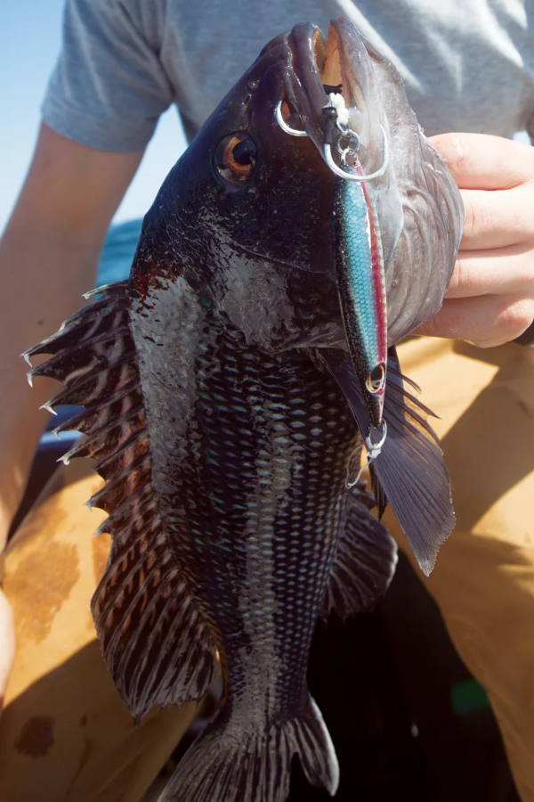
In the two decades I’ve spent working on the water, the days I’ve felt downright smug about my lot in life have been variations on this morning’s undertaking: a windless, flat-ass calm, early-fall hard-bottom recon trip, working on big black sea bass, 3 pounds to more than 6. The world record black sea bass scaled a terrifying 9 pounds and change.

I don’t believe in the hierarchy of “worthy” sportfishing quarry, where a handful of species — tarpon, bonefish, marlin, tuna, striped bass and sails, among others — are ascribed incredible strength, cunning, wits, beauty and prowess, while other species get scoffed at. It’s an underdog thing. It’s also a different ethic about our waters, the fish, the food chain, where the noblest quarry is what everyone eats with gusto, because in my world, the familial (blood or elective) feasting completes a rite that began predawn when we hung the last spring line on its designated piling.

When you lay same-day sea bass on a grocery-store seafood consumer, the gratitude radiates tenfold. Fish this good can’t be bought for all the Franklins in a Manhattanite billfold, but it’s traded for tomatoes or corn, or gifted to neighbors who understand the weight of the gesture.

Few things fill a soul with sacred human purpose like a cooler full of well-iced, bled, rinsed and packed black sea bass — or its yield in well-cut fillets, translucent, almost iridescent, on a plate beside the stove.Our first drift, I hang up inside a minute — one hazard of fishing adrift around the broken ground that concentrates sea biscuits. Cappy rips his rig in, liberates a pair of wallet-sized specimens, each sporting a 4/0 octopus hook that looks, proportionally, the way a gaff head might in the maw of a 3-pounder.

Not what we’re after.I fetch a replacement rig from a bunch dangling off the plumbed bait barrel up against the wheelhouse. I slip on a sinker and bait up with squid and an oozing black glob of sea clam belly (the former for staying power, the latter for scent power) on each hook.

“This feels a little better,” my deckmate announces, just as my sinker contacts the ground floor with a clank.

I note a respectable bend in his heavyish setup. I’m about to speak when I feel a wild thump and discover the fish has more or less hung itself with no help from me. I’m just squaring up to the rail, starting to pry the fish out of the seabed when a strange weightless plucking sensation shoots through the line to my brain. I snap the rod skyward. The tip barely moves.

For a second I worry I’m hung up again, but as I lean back on the rod, I note my new rock is bucking an awful lot.

“Got two,” I announce.

Two good sea bass on one rig have a distinct feel, a weird, disjointed tugging and a consistent, substantial weight. Fish under 5 pounds fight comically hard in a way that makes it almost impossible not to smile, especially when your rig is full-up and you can lean back on the rod, balance yourself against the strain.

I will concede that bottom fishing isn’t a fishery of endless technical complexity, by which I mean: “simple,” not to be mistaken for “easy.

”The fact that we’re in the thick of a sea bass boom doesn’t change one hard truth of the hunt for thick sea bass: the guys who have the real estate, the hangs, the wrecks, the rock piles, the little nothing bump off in the geographic center of mudflat nowhere, the mussel bed in 41 feet surrounded by an acre of 41 feet, the lat-lons corresponding to a bed, two Cadillacs long, one Prius wide, of small, still chewable mussels. Or the little nugget you steamed over on the way to or from tuna grounds, mined 7 years of logbook to find three almost identically worded entries — lat-lons, followed by “load of stuff hard on bottom.”

They’re the ones with the good stuff.Subsequent recon unearthed a flurry of honest-to-Christ 4-pound sea bass and a lone cod pushing 20 pounds. You can now recite the coordinates along with your wedding anniversary, wife’s birthday, your bike lock combination and your first telephone number.

Here’s the deal: You can prattle on for weeks about hooks, knots or teaser colors, but if you don’t have some sea bass ground, debating tackle minutia is like rearranging the Titanic’s deck chairs.

Anyone can catch black sea bass if it’s a purely quantitative exercise. But without the possibility of cracking 5 pounds in the process, I’d rather make a couple swipes at the lunch cooler, stuff my face with cold cuts, wipe my hands on opposing sleeves and stare into the briny middle distance, trying to remember, say, the joke that goes with the punchline, “the potato goes in front.

”Now, after a minute taking back line I’d deployed to hold bottom, the fight is vertical. I’m genuinely surprised how hard the mystery fish are dogging me. I’m half expecting to see a big cod emerge from the murky depths.

“Good one, huh,” says my boss as he dumps his reel in freespool. “Let me know if you need a net on that.

”The suspense is killing me. It could be almost anything down there. A few more cranks, and I see the barrel swivel on my rig flash into view, but still no sign of whatever’s on there. Almost no other species in our waters can out-camouflage a sea bass from above.

A 3-pound sea biscuit has the top hook solidly in its jaw hinge — nowhere near enough to explain this fight.

“I’m up,” I announce, “Got that net?”

The bottom fish is a good one. My partner deftly bags that one first, gathers up the smaller one on the way up. The larger looks obscene. I’d guess 7 pounds if I didn’t know better. So 5, probably.I glance toward my railmate just as his rod goes down hard. A split-second later mine does, too. No head-shakes. No bounce. Obscenities all around. It takes a moment to figure out what’s happening.

The line’s clearly hung up, but there’s some limited play: I can gain about four cranks before it stops dead. We scan in all directions for evidence of lobster gear, the buoys on up-and-down lines, but see none. Probably an unmarked gillnet or a string with too-short buoy lines sucking under in the tide — standard fare for Block Island’s south side. We break off, then gather around the helm to investigate.

Sure enough, it’s a gillnet. We find another string a couple of tics east of where we’d started that first drift, then some lobster gear just west of the mystery net. Trying to anchor hemmed in like that seldom ends well.

Two hours later, a couple dozen solid sea bass and a handful of big porgies on ice, the skipper wants to go check the pots. When sea bass are thick, a mesh bait bag of sea clams seldom holds on beyond a couple of hours. Rod-and-reeling seldom, if ever, keeps pace with good fish pots.

At least we got a few, and more importantly, I got the biggest one in the box, which means Cappy’s buying the Guinness.

This mission was more than a decade ago, well before the abrupt spike in black sea bass populations across the Northeast. With the change came not only more and bigger BSB on the old ground, but swarms in all sorts of places no one could recall having seen them before. The places that had always collected a few suddenly had knots of them. No doubt, the transformative effect of aptly-named Hurricane Sandy had a hand in the distribution shakeup. A storm that changed the entire lay of Block Island’s south side had even more dramatic effects below the low-tide mark. Some known wrecks silted over and vanished completely, while whole constellations of hitherto unknown structures got cleared off and began to take on tenants within a season or two.

More important, climbing water temps — which have sparked a marked shift northward and eastward in the migratory patterns of other stocks, such as summer flounder — have also likely triggered our recent BSB invasion.

In the seasons since, the rod-and-reelers have embraced the advantages of the new arrangement.

Unfortunately, the population explosion has been tempered by one huge regulatory caveat: Lack of the statutorily mandated science to guide decisions, and a call for management accountability, have subtracted from already miniscule catch targets. As stocks grow exponentially and spread out, more anglers catch more sea bass, and landings spike, triggering quota-overage paybacks in each successive year. We call it the “death spiral”: booming resource destroys fishery.

And so a fish in exponential population growth, a fish hard-wired to run other same-tier predators off ground, a fish aggressive enough, fishermen argue, to threaten other rebuilding stocks where they overlap, will flourish indefinitely. Sadly, this fish, which could easily shoulder some pressure from overburdened fisheries such as striped bass, fluke, tautog or cod, remains trapped in bureaucratic limbo.

Our new sea bass bonanza, then, will be fished as black sea bass always have: as a welcome bycatch bonus for guys targeting other species. Then, for a short period according to state regulations, when the possession limit jumps just enough to support an hour or two of dedicated sea bass highgrading, we’ll attempt to put up fillets for winter.

I’m less worried about the big kill than with maintaining the spirit of celebration around seasonal bounty that imposes some predictable order on my charmed life of perpetual adolescence beside the sea.The black sea bass could be the most strikingly beautiful of any creature that lives coastal — long, graceful fins, striking white and electric-blue highlights, big fleshy humps on the foreheads of the joes.

According to my increasingly eccentric take on the fishing life, where the avoidance of macho B.S. lives in my bones, black sea bass swim on both sides of the jagged line between the fire in my belly and the water in my soul: proof that I still live by the grace of the food chain, and evidence, by their very design, of larger gears turning, a greater clockwork presiding over the fleeting eons.

This article originally appeared in the Summer 2019 issue of Anglers Journal magazine.

Mako Shark Tracking


Mako Shark Tracking Reveals “Impressive” Memory and Navigation
from The Fishing Wire

These top predators travel far across the Pacific, returning to the same areas in the Southern California Bight each year. The largest effort ever to tag and track shortfin mako sharks off the West Coast has found that they can travel nearly 12,000 miles in a year. The sharks range far offshore, but regularly return to productive waters off Southern California, an important feeding and nursery area for the species.

The findings demonstrate “an impressive show of memory and navigation.” The sharks maneuver through thousands of miles of the Pacific but return to where they have found food in years past, said Heidi Dewar, a research fisheries biologist at NOAA Fisheries’ Southwest Fisheries Science Center in La Jolla, California.Researchers tagged 105 mako sharks over 12 years—from 2002 to 2014. The tags record the sharks’ movements, as well as the environments the sharks pass through.

Researchers have long recognized that ocean waters from Santa Barbara south to San Diego, known as the Southern California Bight, are an important habitat for mako sharks. Prior to this study, however, they knew little about what the sharks do and where they went beyond those waters.The researchers are from NOAA Fisheries, Stanford University, Tagging of Pacific Predators, and the Center for Scientific Research and Higher Education in Baja California. They reported their results in the journal Animal Biotelemetry.

“We did not know what their overall range was. Were there patterns that they followed?” asked Nicole Nasby-Lucas, a NOAA Fisheries research scientist at the Southwest Fisheries Science Center and lead author of the new research. “It turns out they have their own unique movement patterns.

” Sharks tracked over multiple years returned to the same offshore neighborhoods year after year.

Long-Range Travelers The tagging data overall revealed that the sharks travel widely along the West Coast. They venture as far north as Washington, as far south as Baja California, and westward across the Pacific as far as Hawaii. The sharks tagged off California remained on the eastern side of the Pacific east of Hawaii. This indicates that they do not mix much with mako sharks in other parts of the Pacific.

A roughly seven-foot female mako shark followed similar courses into the Pacific and back to the California Coast over three consecutive years.

Although there are examples of mako sharks crossing the ocean, it is probably the exception rather than the rule, said Dewar, a coauthor of the new research.The finding provides insight into population dynamics of mako sharks across the Pacific. It also allows scientists to identify which fisheries the tagged mako sharks might encounter. Muscular mako sharks are a popular sport fishing target. They are also caught in U.S. longline and drift gillnet fisheries and are common in the international trade in shark fins.

Mako sharks are overfished in the Atlantic Ocean, but not in the Pacific.The researchers used two types of tags to track the sharks. One type, called pop-up tags, collect data and eventually pop off the animal and float to the surface, where they transmit their data via satellite. The second type transmits data to satellites each time the shark surfaces, determining the animal’s location by measuring tiny shifts in the frequency of the radio transmission.

Remembering Southern California Mako sharks are among the fastest swimmers in the ocean, hitting top speeds of more than 40 miles per hour. The larger tagged sharks traveled an average of about 20 miles a day and a maximum of about 90 miles per day. They travel long distances in part because they must swim to move water through their gills so they can breathe, Dewar said.

Large numbers of juvenile sharks caught in the Southern California Bight indicate that it is a nursery area for the species. Tagged mako sharks returned there annually, most typically in summer when the waters are most productive. The tracks of the tagged sharks may look at first like random zig-zags across the ocean, Dewar said. They actually illustrate the sharks searching for food and mates based on what they remember from previous years.

“If you have some memory of where food should be, it makes sense to go back there,” Dewar said. “The more we look at the data, the more we find that there is a pattern behind their movements.”The tagging results also provide a wealth of data that scientists can continue to plumb for details of the sharks’ biology and behavior. About 90 percent of the time the sharks remained in the top 160 feet of ocean, for example, occasionally diving as deep as 2,300 feet. Although the sharks traveled widely, they mainly stayed in areas with sea surface temperatures between about 60 and 70 degrees Fahrenheit.

“We can continue to ask new questions of the data to understand these unique movement patterns,” Nasby-Lucas said. “There’s a lot more to learn.”
Juvenile shortfin mako shark swimming in the waters off California. Photo credit: Walter Heim.

West Coast Rockfish Boom


West Coast Rockfish Boom with Warm Water “Blob”
Young groundfish, including great numbers of rockfish as well as other marine creatures thrived under unprecedented ocean conditions, according to new research.

The high temperatures that came with the marine heatwave known as the Blob led to unprecedented mixing of local and subtropical species. There were, often with new and unpredictable outcomes. Out of that mix came one unexpected winner: West Coast rockfish. These bottom-dwelling species, which that had previously collapsed in the face of overfishing during the 2000s, thrived under the new conditions.

Scientists from Oregon State University and NOAA Fisheries’ Northwest Fisheries Science Center recount the boom in young rockfish in a new research paper in the journal Fisheries. It examines the effects of the Blob as documented by NOAA Fisheries offshore surveys. Scientists have been conducting the surveys for more than 20 years. The Blob years brought some of the most dramatic changes in marine life off the West Coast they’ve ever seen. Unexpected interactions may have also altered the abundance of some species, from plankton that support the food web to fish that depend on them, the researchers wrote.

In the waning months of the Blob in 2016, juvenile rockfish increased over a large area from California to Alaska. Since juvenile rockfish are very difficult to distinguish from one another, scientists could not tell which species benefited. They could not tell what specifically drove the boom in their numbers and or whether they will support fisheries in future years.

They suggested that the surge in rockfish may have been part of an unusual cascade of effects resulting in large part from a shift in the dominant jellyfish off the West Coast. The typically abundant sea nettle declined in number while the less common water jellyfish multiplied to become the most abundant jellyfish in their catches. That may have reduced predation by sea nettles on juvenile rockfish, as well as competition between the species.A catch of mostly water jellies and only a few fish from a 2015 research survey off the West Coast.

“When organisms from different regions suddenly come together, they can interact in unexpected ways,” said Brian Beckman, a research fish biologist at the Northwest Fisheries Science Center and co-author of the new study. “The question is whether this is a lasting change, or one that will shift back toward something we’ve seen before.

”The scientists also described the sudden and extremely high abundance of gelatinous pyrosomes. They, which had never been previously observed in the Northern California Current off the West Coast. Pyrosomes have such voracious appetites that their increase may explain low concentrations of chlorophyll documented off the West Coast in 2017, the scientists suggested.

Pyrosomes found off the Oregon Coast range in size from a few inches to more than two feet long. (Photo by Hilarie Sorensen/University of Oregon)“If this organism remains abundant in subsequent years, it could produce lasting effects upon the ecosystem by outcompeting other filter feeders, which in turn might reduce the food supply to organisms higher in the food web,” they wrote.

The effects of the Blob may be evident in the species mix off the West Coast for many years to come, they added. The scientists emphasized that continued ocean surveys should track those changes over time. This will to help us understand the interaction among species and inform ecosystem-based fisheries management.Read more like this at NOAA Fisheries
Shortraker rockfish.

Winter Feeding Area for Great White Sharks


OCEARCH Defines Winter Feeding Area for Great White Sharks
Tracking data from white sharks equipped with OCEARCH satellite tags reveals that the Atlantic continental shelf waters off North Carolina, South Carolina, Georgia, and the east coast of Florida are a winter hot spot for large white sharks. As seen on the OCEARCH Tracker, the heavy concentration of our adult and near-adult white sharks in this region suggests it’s an important winter habitat, which OCEARCH and collaborating scientists are now referring to as the Northwest Atlantic Shared Foraging Area (NASFA).

This is in concordance with fisheries data that showed this area to be a wintering ground for white sharks, as previously published by OCEARCH collaborator Dr. Tobey Curtis and his colleagues.The OCEARCH Tracker shows at least eight white sharks have been detected in the NASFA in the past week, including adult white sharks Hilton and Katharine. The eight sharks are a good indication there are plenty more white sharks in the area with them.

The waters off Charleston, South Carolina and Cape Canaveral, Florida have seen the highest concentration of detections. The sharks were tagged as part of an ongoing study started in 2012 by OCEARCH to uncover the mysteries of white sharks’ life history in the Northwest Atlantic.

Since the beginning of the study, OCEARCH has consistently observed that nearly all tagged, large white sharks in the Northwest Atlantic visit the NASFA at some point during their migrations, with most visiting in the winter. OCEARCH has tagged white sharks as far south as Florida and as far north as Nova Scotia, Canada, and all of the larger tagged sharks have spent some time in the NASFA.

“The body of colder water trapped between the Gulf Stream and the coast is a key feature of this region,” says Assistant Professor of Marine Science at Jacksonville University and OCEARCH collaborating scientist Dr. Bryan Franks. “This ‘wedge’ of cold water extends from the Outer Banks in North Carolina down to Cape Canaveral in Florida. This feature results in a range of water temperatures in a relatively short horizontal distance from the coast out to the Gulf Stream. In addition, there is the potential for abundant prey in the migrating populations along the coastlines and in the dynamic mixing zone on the Stream edge.

”The tendency for white sharks to migrate to the NASFA bears some similarities to white shark behavior observed in the Pacific Ocean off the west coast of the United States. In the Northeast Pacific, different shark populations migrate from the Farallon Islands and Guadalupe Island to a Shared Foraging Area (SOFA), also popularly referred to as the White Shark Cafe, between the Baja Peninsula and Hawaii.

OCEARCH tracked this white shark behavior in 2007-2009 and conducted a 30-day expedition to the SOFA in 2009. Studies by other scientists since then have tracked similar shark behavior.

OCEARCH tracking data in the Atlantic suggest there could be more than one population, or subpopulation, of white sharks inhabiting the Northwest Atlantic. These populations are differentiated by where the sharks aggregate in the late summer and fall, which is suspected to be mating season for the species, although that remains to be confirmed. Cape Cod, Massachusetts is one such summer/fall aggregation site and OCEARCH data indicates there is at least one more summer/fall aggregation site in Canada. Regardless of which summer/fall aggregation site a shark uses, however, it appears nearly all of the adult and near-adult sharks visit the NASFA during the colder winter months.

OCEARCH is planning an expedition to the NASFA in February and has two other expeditions planned to try and tag more sharks off Massachusetts and Nova Scotia later in 2019. These expeditions aim to increase the sample size of tagged white sharks to get a clearer picture of white shark movements in the Northwest Atlantic and test scientific hypotheses about white shark movement and migration.

“This is the beauty of OCEARCH’s North Atlantic White Shark Study,” said Dr. Bob Hueter, OCEARCH Chief Science Advisor. “The sharks lead us from one step to the next, so that we can steer our ship to where we’re needed to fill in the gaps in our knowledge of this incredible predator. Each expedition builds on the previous ones to reveal the life of the white shark from birth to death in the North Atlantic. This is the best kind of science, and it’s exciting to be sharing these discoveries with our peers and the public.

”Follow the sharks through their migration cycles by accessing the near-real-time OCEARCH Tracker; https://www.ocearch.org/white-sharks-gather-in-northwest-atlantic-shared-foraging-area-off-southeast-coast-of-the-us/