Atlantic sturgeon back in Cheaspeake Bay, or Did They Ever Leave?
from The Fishing Wire
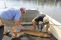
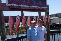
Netted Sturgeon
By Karl Blankenship, Bay Journal:
www.bayjournal.comMatt Bakazik (right) of Virginia Commonwealth University and Chuck Frederickson, a retired lower James Riverkeeper, work to free an Atlantic sturgeon from the gill net in the James River below Richmond where it was caught during a scientific sampling cruise on the James in 2013. (Leslie Middleton)

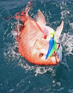
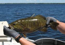
Face only a mother sturgeon could love
This Atlantic sturgeon was caught in Maryland’s Marshyhope Creek in late August 2014. (Dave Harp)
A couple of decades ago, a handful of scientists met to discuss the dismal state of the Atlantic sturgeon in the Chesapeake Bay. No researcher had seen a spawning sturgeon in years. Some doubted whether a remnant population of the Bay’s largest fish even remained.
Finally, the scientists began to debate what to do if someone actually caught a spawning female.
Some thought they should send her to a hatchery to preserve her unique Bay genetic makeup. Others thought they should tag and track her to see if she led to another sturgeon.
“We went back and forth about what we would do with the ‘last’ sturgeon,” recalled Dave Secor, a fisheries scientist with the University of Maryland Center for Environmental Science. “That discussion has changed.”
Thought nearly extinct in the Chesapeake just two decades ago, sturgeon are turning up in surprising numbers and in surprising places. They’re also doing surprising things, like spawning in the fall – unlike any other anadromous fish on the East Coast.
Much of what was common knowledge 20 years ago is being cast aside as discoveries come at an increasingly rapid pace. “What we would have said a year ago about sturgeon, we wouldn’t say today,” said Chris Hager, a biologist which Chesapeake Scientific, a consulting firm, who has studied the big fish for more than a decade.
A few years ago, most biologists would have said that only the James River had a reliable, if small, breeding population. Now, some think the James alone holds a population that could number in the thousands. Next door in the Pamunkey, scientists last year documented a spawning population.
This year, Maryland biologists caught eight ready-to-spawn fish in Marshyhope Creek on the Eastern Shore. “And if you go by what the fishermen are telling us, there’s a lot more of them out there,” said Chuck Stence, a fisheries biologist with the Maryland Department of Natural Resources.
Jumping sturgeon have been reported in the Mattaponi which, like the Pamunkey, is a York River tributary. In Maryland, jumping sturgeon were reported in the Nanticoke River, upstream of its confluence with the Marshyhope.
Biologists expect to expand their sturgeon searches into those rivers next year. And they tick off other rivers they consider candidates for hidden sturgeon populations: the Rappahannock, the Potomac, maybe even the Choptank and Chester.
“If they are up in the Pamunkey, they can be anywhere,” Hager said. “They are not going to be everywhere, but you are going to have to explore it, and I think that is going to continue to go on for quite some time.”
Sturgeon are generally considered a big river fish. Yet they seem to be spawning in narrow parts of the James, and small tributaries like the Pamunkey and Marshyhope that, as Secor said, “you could throw a stone across.”
Not only are those areas relatively small, they are also relatively well-monitored compared with other Bay tributaries. So it comes as a surprise that sturgeon adults, which routinely measure more than 5 feet in length and are known for their habit of jumping out of the water, could have been overlooked.
“The thing is, you’ve got to look and nobody was looking at sturgeon,” said Albert Spells, Virginia fisheries coordinator with the U.S. Fish and Wildlife Service who, in the 1990s, was one of the few who argued that breeding populations remained in the James. “We just were not putting enough effort into this animal.”
An Intriguing Fish
Sturgeon catch the imagination of scientists and the public alike. Sometimes called “the fish that swam with dinosaurs,” they are remnants of an ancient species and don’t look much like other fish. They have long, pointed snouts and instead of scales, are covered with armor-like bony shields, called scutes.
They are, by far, the largest and longest-lived species native to the Chesapeake. They reach maturity when they are 10 to 15 years old, and 5 feet or greater in length. They have been documented to live 60 years, and reach lengths of 14 feet and weights of 800 pounds.
Like other anadromous species, they spawn in coastal rivers, but spend most of their lives in the ocean. Colonial accounts are filled with stories about their abundance. Capt. John Smith wrote “no place affords more plenty of sturgeon,” and sturgeon meat was one of the Jamestown settlement’s first exports. But fishing pressure in the late 1800s and early 1900s, primarily for caviar, devastated the population.
The sturgeon’s slow reproductive rate, combined with other insults such as the destruction of spawning grounds (they were dynamited for shipping channels in the James) and water pollution (sturgeon are particularly sensitive to low-oxygen conditions) kept their numbers low.
In 2012, the National Marine Fisheries Service listed as endangered the Chesapeake Bay “distinct population segment.” At the time, it estimated that fewer than 300 sturgeon still used the James River for spawning. No other Bay tributaries were known to have sturgeon spawning, though the listing decision speculated that some spawning might take place in the York.
It now appears that one reason adult fish were overlooked is that biologists were looking at the wrong time.
As concerns grew that Atlantic sturgeon could be headed toward federal Endangered Species Act protection, there was an uptick in funding to look for fish, primarily in the James River. Initially, the biologists concentrated their search in the spring. They caught mostly juvenile fish.
Over time, they noticed that adults tended to turn up later, and farther upstream, than expected. In September 2011, Matt Balazik, a fisheries biologist with Virginia Commonwealth University, netted a female that had recently released eggs.
At the time, most fish biologists scoffed at the notion that sturgeon spawned in the fall. But since then, Balazik has netted hundreds of adult sturgeon on the James during the summer and fall, including females filled with eggs and males leaking sperm. That ended the debate. In recent years, evidence of fall sturgeon spawning has been seen in states farther to the south as well.
“A lot of people were looking at the wrong time,” Balazik said. “If we were looking just at the spring, we would say, ‘Oh my gosh, there’s nothing here.'”
Evidence for fall spawning isn’t new. Alexander Whitaker wrote of Virginia in 1613 that “The rivers abound with fish both small and great. The sea-fish come into our rivers in March and continue [to] the end of September,” and noting that the “multitudes of great sturgeons” came in last.
American Indians named August’s full moon the sturgeon moon because of the abundance of sturgeon in the rivers at that time. “It has been there the whole time that these fish spawn in the fall,” Balazik said.
In fact, Balazik and others believe that the James and other tributaries historically had – and in many cases still have – a distinct spring and fall spawning run. They suspect the spring run was historically larger, but that it took the brunt of intensive fishing. Fall spawners, by arriving later in the summer, might have missed fisheries targeting other anadromous fish.
“Historically, probably the spring run was the big one and the fall one was much smaller. But because of the overfishing, the spring run maybe hasn’t come back,” said Greg Garman, director of the Center for Environmental Studies at Virginia Commonwealth University. “Maybe things have flip-flopped and now the fall run is the much bigger contributor, at least in the James.”
But Why the Fall at All?
What’s uncertain is why sturgeon began spawning in the fall. East Coast anadromous species – such as striped bass, shad and river herring – typically spawn in the spring. They follow temperature cues up rivers, and masses of fish arrive on spawning grounds at the same time where, historically, vast numbers of males and females would mix together and release eggs and sperm into the water.
One advantage of spring spawning is that biological systems are coming back to life after the dormancy of winter. Fresh plankton blooms fed by spring runoff give larval fish plenty to eat so they can grow rapidly. Conversely, in late summer and fall, biological activity in river systems is starting to slow.
But perhaps, some suggest, larval fish produced in this region in late summer have less competition for plankton and therefore have just enough food, and time, to get big enough to survive the winter.
“My gut feeling is that if you could get offspring to a certain size so they could overwinter, then it is sort of a head-starting program for the spring when the rivers become much more productive,” said Eric Hilton, who has been working with sturgeon on the York and Pamunkey.
The discovery of new populations also raises other questions: such as whether sturgeon in various tributaries are closely related.
Once, it was presumed that fish in adjacent rivers were closely related and would behave similarly. For instance, it was assumed that fish in the York River system were closely related to those in the James – perhaps even James River fish that simply strayed next door.
Initial genetic work, though, hints that Pamunkey sturgeon are “completely distinct” from the James River fish, said Carter Watterson, a Navy senior marine fisheries biologist stationed in Norfolk.
The biologists have only been looking in the Pamunkey for two years, but there is evidence the Pamunkey sturgeon also behave slightly different from James River fish. Adults, for instance, seem to return a bit earlier in the summer, said Jason Kahn, a fisheries biologist with the National Marine Fisheries Service.
Equally perplexing is that while scientists have tagged about 50 sturgeon in the Pamunkey, none have ventured into the adjacent Mattaponi, even though the two rivers merge to form the York.
Meanwhile, the Virginia Institute of Marine Science this year logged about 40 reports of sturgeon jumping in the Mattaponi. If those fish aren’t from the Pamunkey, Watterson said, it raises the possibility that the York River system could have two distinct populations – one in the Pamunkey, and one in the Mattaponi.
That, along with a potential breeding population on the Marshyhope, suggests that Bay sturgeon have several unique, small populations. Because of their small numbers, those populations could be at high risk – and each may need protection.
“If we find out that each river where we find sturgeon has a separate spawning cue as part of its genetic architecture, then I think we are obliged to try to conserve these populations at that level,” Secor said.
Further, he said, if it turns out that separate spawning runs on the same river are genetically distinct, they may each need to be treated separately as well. This is similar, Secor said, to how Pacific salmon that have distinct spawning runs on the same river are managed.
And there is reason to think there are distinctions between spring and fall spawners. Biologists have caught fewer spring fish on the James, but those that have been caught seem to spend less time in the river and are bigger. The smallest male caught in the spring is larger than 95 percent of the males caught in the fall, Balazik said. Some also think spring fish spawn in different areas farther downstream, but no one is certain, as too few have been captured.
Separate spring and fall spawning stocks would mean adult fish are in the river longer, and therefore need to be protected from other activities for a longer portion of the year. “It would completely change what that recovery plan looks like,” Garman said.
More Fish? More Eyes? Or both?
Meanwhile, the biologists wonder if the sturgeon population is actually larger, or whether they are just getting better at finding the fish, or might it be as some believe, both.
“That is a hard question to answer,” Hilton said. “Probably a little bit of each. We are definitely getting better at finding where they’re at, and when they are there. But my suspicion is that they are now more prevalent.”
If there are more fish, there are several factors that might have contributed to a rebound.
Years ago, Secor and colleagues developed a habitat suitability model for juvenile sturgeon that showed several years in the late 1990s had exceptionally good conditions to promote growth and survival for young sturgeon. At the time, they didn’t know any sturgeon were left to take advantage of those conditions. But any sturgeon spawned in those years would now be reaching maturity.
“That’s what I think happened,” Secor said. “Things got good in the late 1990s and we are seeing those adults coming back in.”
The fish also could be benefitting from a coastwide ban on sturgeon catches implemented by Atlantic States Marine Fisheries Commission in 1998, and even earlier bans on their catch in the Bay.
They also may have been helped from pollution reductions at wastewater treatment plants forced by the Clean Water Act in the 1970s and ’80s, as suspected spawning areas in many Bay tributaries are just downstream of major urban areas that for decades discharged huge amounts of sewage with little treatment.
At the same time, more effort is going into looking for sturgeon. More biologists, who are gradually learning to look in the right places at the right times – and with better techniques – may also explain part of the uptick in sturgeon numbers. The National Marine Fisheries Service has sent more grant money to states and academic institutions to look for and study the biology of sturgeon.
One of the biggest research investors has been the U.S. Navy. It has numerous activities in the Bay that could be impacted if they interfere with endangered sturgeon. The Navy has paid to implant acoustic tags in sturgeon and has established a network of 75 receivers in the Lower Bay to track the sturgeons’ movements.
The Navy also helped fund the search for more sturgeon, including recent efforts in the York River system, which turned up the spawning fish in the Pamunkey.
With all they’ve learned, biologists are confident they’ll find fish in other rivers. But, “It is going to take some time, some effort, some studying and probably a whole lot of luck,” Kahn said.
Still Threatened
The sudden proliferation of sturgeon findings doesn’t mean the big fish are free of threats.
They still face the risk of being caught in bycatch in other fisheries, habitat destruction, water pollution and ship strikes because they seem to move in deep shipping channels. Just this spring, two females that had recently spawned were killed by a ship strike in the James River.
But the early life stages of sturgeon are the most vulnerable. Although biologists have ideas of where sturgeon spawn in various rivers, they have not confirmed exact locations. In fact, despite the recent success in catching adult spawners, no one has confirmed reproductive success by finding sturgeon eggs and larvae in a spawning area.
“That is the next big step,” Secor said. “If we want to restore Atlantic sturgeon and make effective recovery plans, those early life stages are the ones that determine whether populations recover or not. That is where the growth and mortality rates are going to be highest, so that is the bottleneck. But it is the hardest stage to sample.”
There are reasons for concern. On the Pamunkey, when Kahn and colleagues deploy nets looking for early-life stages of sturgeon, they often come up with nets full of blue catfish, an invasive predator whose population has rapidly grown.
Whether they are a problem is unknown. “But logically speaking, there is no reason that a large predatory fish would not feed on a small fish,” Kahn said.
Failure to identify spawning areas also has limited protection. Hager talks of how a house recently was built near a suspected spawning area on the Pamunkey. Trees were cut down and a bulkhead built, both likely to increase sedimentation on the clean, hard, cobble river bottom. Sturgeon eggs are sticky, and need to attach to clean cobble bottom. Even a thin layer of silt on the bottom can keep that from happening.
“I think the populations in some places are probably so small that they are very delicate and they could be wiped out with stupidity,” Hager said.
And, spawning seems to be taking place on smaller waterways than what was once thought, which are more vulnerable to a sudden spike in poor water quality, Secor noted.
Still, the outlook for sturgeon is considerably better than it was two decades ago, when biologists debated what to do if they caught the last one. “If I were to pick a designation for the Atlantic sturgeon, it would be hopeful.” Hager said.
Spells, who repeatedly challenged his colleagues to put more effort into looking for sturgeon during the “last fish” debate two decades ago, is pleased by the new discoveries. “One of my objectives back then was just to get people interested in sturgeon and start spending some time looking.”
But even he is surprised at how drastically the sturgeon story has changed. “I’d be lying if I said that I thought we would know as much as we do today. I’m just happy that people are starting to look.”

Karl Blankenship
About Karl Blankenship
Karl Blankenship is editor of the Bay Journal and Executive Director of Chesapeake Media Service. He has served as editor of the Bay Journal since its inception in 1991. To read more of his articles, visit
www.bayjournal.com.