There Are Good People Out There

Last year Jack Ridgeway introduced me to Randy and Wyatt Robinson. Wyatt was a student at Crosspoint Christian Academy and on the fishing team there. I tried to help them get ready for a high school tournament at Allatoona.

I’m not sure how much I helped, but the last two years they have helped me a lot! I have met some great folks through fishing and they are two of the best. Sometimes I feel like our society has destroyed good people. If you watch much news, it surely seems that way.

But there are many good folks out there, more than you realize from all the publicity the bad ones get. Randy is dedicated to working with Wyatt, doing everything a good parent does to help his dreams. As his boat captain, Randy spends many hours in a boat, driving the boat but the rest of the time just watching them fish.

He also provides a great environment for a youngster growing up. Wyatt hunts and recently killed a nice buck. I’m not sure he realizes how lucky he is to grow up in a home like that, much like I did not realize how lucky I was as a kid until I moved away from home. I just wish every kid could be as lucky!

November Bartletts Ferry Tournament

On Sunday, November 25 nine members of the Spalding County Sportsman Club fished our November tournament at Bartletts Ferry. After eight hours of casting we brought 27 keeper bass to the scales weighing about 32 pounds. There were two limits and one zero.

Jay Gerson won it all with five weighing 9.22 pounds and his 4.09 pound largemouth was big fish. Wayne Teal had four weighing 6.84 pounds for second, my three at 5.60 pounds was third and Billy Roberts had five weighing 4.60 pounds for fourth.

Driving to the lake the fog was so thick it was a slow trip. I thought I would have to change my plans of running about five miles to start on a point I like where I caught fish in September, but when we got to the lake there was little fog on the water, a surprise.

I should have changed my plans anyway since I did not get a bite for almost two hours. At 8:45 I landed a 3.12 pound largemouth on a shaky head so that fired me up, but I didn’t get another bite for two more hours, then lost a solid keeper that jumped and threw my jig head worm.

About ten minutes later I hooked and landed another good keeper largemouth, making me feel a little better. But two hours later I had not gotten another bite until a keeper spot hit my worm. That was it, I got no more bites before having to go in. I was surprised to place in the tournament with just three fish, but everybody had a tough day.

I was happy to see 14 of the 27 bass were largemouth. And three of them weighed more than three pounds. Back in the 1970s and 80s we caught a lot of good largemouth there, many in the five to six-pound range. Then spotted bass invaded the lake and for years we had a hard time catching largemouth.

Spots are not native to middle Georgia lakes and when they get in one they are so aggressive they tend to crowd out the largemouth. That has happened on Jackson, West Point and Bartletts Ferry.

Hopefully the spots are getting reduced and the largemouth are coming back some. One reason Bartletts Ferry has changed is the hydrilla there. That underwater weed offers largemouth great habitat but not so much for spots.

The Chattahoochee River feeding Bartletts Ferry has had a lot of hydrilla in it for several years and it had spread to the lower lake. Last year there were thick beds of it, helping the largemouth. Unfortunately, the Alabama DNR sprayed and killed most of it on the lower lake. I wish they would leave it alone.

Integrating Red Snapper Data

NOAA Fisheries, Gulf States Prioritize Integrating Red Snapper Data

At a recent workshop, Marine Recreational Information Program partners discussed how data collected by general and specialized recreational fishing surveys can help deliver more timely and precise catch estimates for Gulf red snapper.
From The Fishing Wire

Red snapper grow big


Photo courtesy of FWC Fish and Wildlife Research Institute.
The Marine Recreational Information Program (MRIP) partnership took another step toward delivering more timely and precise estimates of Gulf of Mexico recreational red snapper catch and effort. At a September workshop co-hosted by MRIP and the Gulf States Marine Fisheries Commission, scientists and managers from state agencies, the Gulf of Mexico Fishery Management Council, NOAA Fisheries, and independent statistical consultants sought to identify the best way to use data collected by specialized and general state-federal surveys to monitor recreational catches of Gulf red snapper, as needed to support stock assessments and fishery management.

The Red Snapper Survey Designs Workshop IV was the latest in a series, dating back to 2014, focused on finding ways to better monitor catches during short federal and state fishing seasons for one of the Gulf’s most popular fish. NOAA Fisheries and its Gulf state and regional partners have spent the past several years working closely to develop survey designs that address federal and state management needs for more timely and statistically precise catch statistics.

Since last December, NOAA Fisheries has certified designs for three surveys in the Gulf of Mexico: Louisiana’s all species, general survey, LA Creel; Mississippi’s red snapper-specific Tails n’ Scales; and Alabama’s red snapper-specific Snapper Check. Florida’s Gulf Reef Fish Survey, which supplements MRIP’s general surveys for a limited group of reef fish species, is expected to be certified later this year. Each survey uses a different methodology to gather data and produce estimates based on the unique characteristics of the state’s fishery.

“This is all part of a comprehensive, collaborative, and rigorous process to ensure sound and effective science and management of Gulf red snapper,” said Gregg Bray, GulfFIN program coordinator for the Gulf States Marine Fisheries Commission. “It’s so important to have the leadership and local knowledge of the states, the collaborative strength of GulfFIN, and the financial and technical resources of NOAA Fisheries. That’s the real value of the MRIP partnership.”

The MRIP state surveys are designed to improve regional monitoring of the recreational red snapper catch and effort. Estimates from these surveys can be used for federal scientific stock assessments and fishery management once there is a transition plan that describes how to integrate state and general data, and how to calibrate new and historical catch and effort estimates.

During the workshop, participants were introduced to several options for integrating data collected by the specialized and general MRIP surveys and for calibrating estimates generated by the new integrated survey approaches against estimates based only on the general surveys. Calibrations will be needed to ensure that red snapper catch estimates produced by different survey designs can be converted into a common currency for use in stock assessments and management.

As a next step, the Gulf States Marine Fisheries Commission will coordinate the delivery of survey data and estimates to a team of independent statistical consultants who will explore the integration and calibration methodologies put forward at the workshop. The need for a follow-up workshop to present and discuss the results of the analysis is under consideration for early 2019. A workshop summary is being prepared and consultants are expected to provide a report following the completion of their analysis.

Read more like this at NOAA Fisheries here:

Thanksgiving, Weather and Climate Change?

Thanksgiving came really early this year. A results of climate change, no doubt.

On a more serious weather note, we had our first freezing weather this past Tuesday, November 25. That is a little later than the average, since the historical average is on November 11. But the first freeze here on record was October 14, 1988. The latest was December 26, 1918. We were well within that range.

Weather and climate change. Weather changes day to day to day and even hour to hour, but climate change is a long-term trend over many years. No doubt it is changing, but how much is man made is open to debate unless you have an agenda and insist the science is “settled.” Real science is open to adjustments based on new information, and almost all science has changed over the years.

The day after Thanksgiving the National Climate Assessment (NCA) was released. This gloom and doom report, based on their computer models, came from government agencies with agendas. Their recommendations were that everyone sacrifice our lifestyles to avoid perceived catastrophes.

Some problems with this report include:

1. The report claims climate change will cost the US economy 10 percent of gross domestic product by 2100. But that projection is based on our climate being 15 degrees warmer by then.

That is a guess way beyond even the UN’s guesses from the International Panel on Climate Change. That group guesses the change at that time will be less than one-fifth, or just under three degrees, of that.

2. The NCA predicts more hurricanes, floods and wildfires. But last year, in the annual report for that year, it shows no increase in any of those. This has been a bad year for all three, they claim, but one major hurricane does not make a trend, and a state mis-managing their forest to protect endanger species, leading to worse wildfire dangers, does not equal climate change.

The NCA also uses timelines for their projections with arbitrary starting and ending dates, cutting off their information to show trends longer term timelines do now support.

3. The NCA report would lead to the IPCC recommendation of a huge carbon tax by 2030. That would increase your electric bill so much you could not afford to run air conditioners, heaters or most electric appliances. And your gas would cost would go us so much you could not afford to drive.

I will pay attention to the doomsayers when they lead by example. As soon as they walk or ride horses everywhere they go and stop all use of electricity produced by fossil fuels, including that used to charge their electric cars, I may pay a little more attention to them.

Last Thursday it was 27 degrees at daylight but 60 by 3:00 PM, a change of 33 degrees. But I didn’t see dead animals everywhere from that drastic change. The lake water at Lake Martin dropped five degrees last Tuesday in the six hours I fished, but dead fish didn’t float to the surface.

Like wildlife, we adapt to daily changes much more drastic than the projections from government agencies wanting to spend our money and make us change our lifestyles while not changing their own.

Goliath Grouper Study

Florida FWC Uses Telemetry in Goliath Grouper Study
from The Fishing Wire

Goliath Groupers grow big!


Photo Credit Florida International University
Acoustic telemetry is used to measure impacts of catch-and-release fishing on Goliath grouper and to determine behavior patterns of this federally protected species.

Goliath grouper (Serranidae: Epinephelus itajara) occur in tropical and subtropical waters from the west coast of Africa to the east coast of Florida, south to Brazil, and throughout the Gulf of Mexico and the Caribbean Sea. One of the world’s largest groupers, this species can grow to over 7 feet long, exceed 750 pounds, and live at least 37 years. Goliath grouper grow slowly, mature relatively late (4-6 years old), and aggregate to spawn.

Harvest of goliath grouper was prohibited in U.S. waters in 1990 after a noted decline in population numbers. In 1994, they were listed as critically endangered on the IUCN World Conservation Union’s Red List of Threatened Species (www.iucnredlist.org). Goliath grouper are currently protected from harvest in U.S. waters though there are fisheries for goliath grouper in some countries. The status of the species throughout its entire geographic range is unclear and there are many factors that increase goliath’s susceptibility to overfishing. For more information regarding goliath grouper biology and regulations, please visit the Goliath Grouper Web section.

Protection from harvest does not ensure that fishing mortality is negligible. Recreational fishing charters throughout Florida advertise goliath grouper as a prime target species for catch-and-release fishing. A fish of this size produces a challenging and exciting fight on rod and reel. Goliath grouper are also often caught unintentionally during angling efforts for other reef species. While their primary diet consists of slow moving, bottom-dwelling species, they are opportunistic predators that occasionally feed upon a struggling fish being reeled in by anglers.

To date, the effects of catch-and-release angling on goliath grouper have not been established. As with many reef fish, angling at deeper depths may result in gas expansion and extensive boat-side handling that can cause injury or mortality. Additionally, goliath grouper often remain at the same sites for extended periods, so repeated capture events may affect their survival at heavily fished sites.

Goals

The primary goals of the goliath grouper telemetry program are twofold:

To describe the effects of catch-and-release angling on the survival of goliath grouper across a range of depths.
To quantify the long-term behavioral patterns and residence times of goliath grouper within the study area.
Acoustic telemetry and conventional tagging will be used to assess both immediate and long-term effects of catch-and-release angling and to provide data regarding residency and behavior of this protected species. Goliath grouper are known to remain in the same area for extended periods, and they have a tendency to aggregate around habitat such as shipwrecks. The monitored shipwrecks in this study (Figure 1) have been chosen based on ongoing research that indicates consistent goliath grouper presence. Quantitatively assessing the effects of catch-and-release angling for goliath grouper, in addition to continued investigation into population dynamics, movement patterns, and stock structure, will provide valuable information for future management or regulation.

Methods

Goliath grouper are caught using typical recreational fishing gear. Once at the surface, goliath grouper are left in the water and positioned at the side of the boat so that they can be measured, photographed, and fitted with tags. Two external tags are inserted just beneath the dorsal fin. The first is a conventional ID tag (Figure 2), and the second is an acoustic transmitter, or “pinger” (Figure 3). Each pinger has its own unique code that will allow for the identification of individual fish. Goliath grouper are tracked manually immediately after release, which provides information regarding short-term survival and behavior after a catch-and-release event.

Two to four acoustic receivers (hydrophones) are permanently deployed at each monitored shipwreck. Each receiver has a listening area of approximately 500,000 square meters, or 124 acres. Whenever a tagged fish swims within listening range (Figure 4), a hydrophone will record the fish’s individual ID as well as the time, date, and depth of the fish within the water column. These data will yield information regarding long-term movements and behavioral patterns of goliath grouper at the study sites.

Conventional external ID tags are attached to each goliath grouper to provide recapture/resighting data through diver surveys and angler recapture reports. Any tagged fish that are observed should be reported to the Florida Fish and Wildlife Conservation Commission’s (FWC) Angler Tag Return Hotline, 800-367-4461. Researchers need to know the date and location of the sighting and the relative condition of the fish.

Movement and behavioral data will indicate the effects of catch-and-release fishing on this reef species. Minimum estimates of survival immediately after a catch-and-release event can be assessed. Long-term acoustic telemetry data will allow for estimates of residence time for individuals at specific sites. Continued underwater surveys will provide further information regarding abundance, size distribution, and seasonal patterns for goliath grouper within the study area. It is the goal of this project to synthesize these data for a better understanding of goliath grouper biology and ecology that can support the development of responsible and effective management.

To learn more about our telemetry studies, visit the Acoustic Telemetry Research section.

How Are Biologists Keeping Tabs on Migratory Sportfish?

Keeping Tabs on Migratory Sportfish

Seaguar continues its support of Gray FishTrag Research roosterfish study
from The Fishing Wire

Tagging Rooster Fish


New York, NY ( – There has never been a more critical time to learn about the marine fisheries that we rely upon for sport and commerce. Such research faces significant headwinds, as many of the target pelagic species frequently migrate hundreds, if not thousands, of miles during the course of their lives, and public resources to support detailed population studies are limited. Nevertheless, anglers and scientists have forged a unique partnership – Gray FishTag Research – in an effort to gather high-quality data on marine fish population dynamics, migration patterns, growth rates, habitat preferences, and more.

Seaguar, the originators of fluorocarbon fishing line, is proud to support the efforts of Gray FishTag Research to study and protect sustainable marine fisheries around the world.

Gray FishTag Research is a non-profit organization, leading an international and fully interactive fish tagging program powered by the world’s largest network of fishing professionals, consisting of approximately 10,000 charter boat captains and mates. Tags are deployed on fish that are caught and subsequently released; data are collected when a tagged fish is recaptured, or from pop-off satellite tags that record data electronically and then “pop off” the tagged fish after a predetermined about of time. Fish tagging and recovery data is made available, free of charge, to any interested parties through the Gray FishTag Research website.

Seaguar sponsors a unique Roosterfish study off the coast of Costa Rica in memory of long-time Seaguar sales manager, John DeVries. Tagged roosterfish are fitted with pop-off satellite tags, and data collected from the tags after popping off the roosterfish yields detailed information about the tagged fish’s movements, both horizontal and vertical, during the time that the tag remained attached. Recently, Gray FishTag Research announced the recovery of not one, but two pop-off satellite tags that were deployed during a Seaguar-supported tagging expedition:

The first PSAT tag, on a fish named “Las Gatos”, was deployed on April 28, 2018 and popped-off 58 days later. Not only was data transmitted by the tag after pop-off, but the tag itself was actually recovered, found by a local angler who recognized the importance of his discovery and returned the tag to Gray FishTag Research for more detailed analysis.
The second PSAT tag, on a fish named “Nicaragua”, was deployed on June 9, 2018 and popped-off 17 days later, off of the southern coast of Nicaragua. This fish traveled an amazing and noteworthy distance of at least 228 miles during the 17 days that the PSAT tag remained attached to the fish.
Seaguar also supports the work of Gray FishTag Research to enhance our understanding of swordfish movements and population dynamics through a fish tagging and recovery study. Recently, a tagged swordfish that entered the study in late 2017 was recovered, nearly eight months and 500 miles later!
On December 16, 2017 a swordfish was tagged by angler Anthony DiMare while fishing with Captain Nick Stanczyk aboard the Broad Minded charter boat out of Islamorada, Florida. The swordfish was estimated to be 47 inches in length and had an approximate weight of 50 lbs. On August 11, 2018, a full 238 days later, that swordfish was recaptured by NOAA observer McKenzie O’Connor while aboard PLL Vessel Ellen Jean. The recapture location was approximately 475 miles away from the tagging location. The measured length of the recaptured fish was 55 inches, and it now weighed 96 lbs.

Gray FishTag Research is an essential tool for promoting the sustainability of marine game fish and increasing public resource awareness. All fish species in every ocean are being monitored, including billfish, sharks, general offshore and inshore fish species. The program collects information in real-time by providing a direct connection between anglers and the scientific community, in every part of the world.

Seaguar is proud to continue our support of Gray FishTag Research as it yields unique and invaluable data about our most important marine fisheries. The dedicated anglers who capture, tag, and release fish as part of the study, and the diligent scientists who process, analyze, and report tagged fish data, are the perfect embodiment of Seaguar’s motto; just like our lines and leaders, these professionals are Always the Best!

Cost of Common Sense Climate Change Hysteria

I always get a kick out of the claims of a true believer in whatever the current name for weather. They call me a “skeptic” or “heretic”, reinforcing my use of the term “true believer.” So far, they don’t demand I be burned at the stake, maybe that would produce too much carbon!

Both sides have scientific information on their side but ignore or make wild claims about the science they think supports the other side. But only one side, the true believers, claim the science is settled.

Science is never “settled,” new information changes it. After all, in the early 1400s settled science said the earth was flat, and in the 1970s it said we were due for another ice age by the year 2000 if we did not make drastic changes to our lifestyles. Sound familiar?

In 1975 while working on my first Masters

Degree I had to write a research paper on global cooling. The “settled” science then said our lifestyles had to change and we had to spend billions of other peoples’ money to avoid a new ice age, with glaciers covering half of the US by the year 2000. When that “settled” science didn’t work out too well for them they changed the name so it would fit any weather we had.

Closer to home for me right now, cancer research for the past 100 years has settled the question of why our bodies immune system does not fight off cancer. Science was “settled,” except for a few skeptics, that our immune system thought cancer was a normal body cell so did not attack it and nothi9ng could be done about that “fact.”

A few weeks ago, two research scientists, call them skeptics, won the Nobel Prize in medicine for their breakthrough research that found an enzyme in cancer cells fools our immune system into thinking the cancer is normal cells. They have been able to deactivate this enzyme in mice and the tumors were killed, offering new hope for a new cancer treatment that goes against 100 years of settled science.

My biggest problem with true believers is their claim that “common sense” demands the government spend billions of our tax money and we make drastic changes to our economy and lifestyles. The problem with using the term “common sense” tries to imply those that disagree are totally wrong, and any cost is worth it.

The U.N.’s Intergovernmental Panel on Climate Change said that efforts to stabilize levels of greenhouse-gas emissions would require investments of about $13 trillion in the next 12 years. It also noted that reducing emissions would reduce the rate of economic growth, costing much more in the long term. Just the cost of switching from carbon fuels to alternative energy sources would cost 44 trillion between now and 2050.

That report does not mention the problem of reliability of alternative energy, the more dangerous smaller vehicles, and lack of and inability to accomplish some goals. For some, a tiny tin can car may be fine, but if you hunt or fish, especially if you pull a boat or trailer, they do not work.

Some will say we have to make sacrifices, but they almost always want others to make those sacrifices. Every time I see celebrities and politicians with private yachts and jets say I need to cut back on my carbon use I can only shake my head. One cross Atlantic trip for them to attend a climate conference in their jet uses more carbon that I will in a lifetime of fishing and hunting using my truck and boat.

Just like they want to spend my money, they want us common folks to change our lifestyles while they live in luxury, changing nothing. And they demand we make those changes immediately, before their “settled science” changes.

Another “settled science” claim is low lying islands will be uninhabitable due to melting glaciers causing sea level rises. They say sea levels have risen about 8 inches in the past 150 years and are predicted to rise another sixteen to 48 inches in the next 100 years. But almost every example of this I could find says the islands are getting smaller due to sea level rise AND erosion.

A 2017 study by Duval and other looked at 111 islands “threatened” by sea level and erosion changes. Their study covered the past 50 years and found only nine that had actually gotten smaller. Fifteen had gotten bigger, with the vast majority not changing.

All this claim of change is based on computer models of our climate. But those models are only as good as the programmer writes them, and they depend on data input that can be manipulated. If you have a computer, you know how unreliable they can be. Auto spell correct is a computer model on your phone. How accurate is it?

I took a cruise up Glacier Bay National Park a few years ago. The naturalist told us the open water in the bay was 110 miles long. In 1764 when it was discovered it was covered by glaciers. They had retreated 110 miles in just over 250 years. And the fastest retreat took place from 1860 to 1870. I guess it was all those Civil War SUVs! There are 1045 glaciers in the bay and some of them are growing, not retreating. Why? They are not affected by climate change?

If our settled science is correct, our environment has always changed and probably always will. I have seen a lot of different weather in my 60 plus years outdoors, but climate changes very slowly, not fast enough for a person to see.

I have faith in human nature enough to know we adapt to climate change and thrive no matter what happens. And I see no sense in doing all the drastic, expensive changes to our lives because some computer models and true believers say its “common sense.”

Lefty Kreh Estate Auction

Eye-Opening Weekend for Lefty Kreh Estate Auction
Jim Shepherd
from The Fishing Wire

When we carried the notice last week that Lang’s Auctions, Inc. would be selling off items from the estate of esteemed writer, angler and innovator Bernard “Lefty” Kreh, I knew I had to put the dates into my calendar and check it out.

I did, and it was an eye-opening event. I grew up around the auction business. From cars and trucks, to estates, houses, and livestock including cattle, horses and the occasional llamas, camels and other zoo critters to used furniture, my family was involved in auctions. The word involved is far more accurate than saying we were interested in them, because for several years, my dad had a small auction house.

It was there where I first realized that people can get so into the competition of bidding that their brains seem to close down. That’s how you wind up coming home to try and explain a $75 dollar “bargain” lamp that has a $12 price sticker on its base. You got caught up in the competition rather than keeping a cool head.

The Lang’s auction, however, was totally different from the ones of my childhood. This was much more closely related to a Christie’s auction. Great catalog, wonderful illustrations and accurate descriptions of the items offered. The one area where they were wrong was the portion that was so eye-opening: the estimated price ranges for the items.

I had an eye on this personal letter from President George H.W. Bush to Kreh. As a fan of both, I thought it a great two-fer, especially at the $100-150 estimated auction price. I didn’t win.
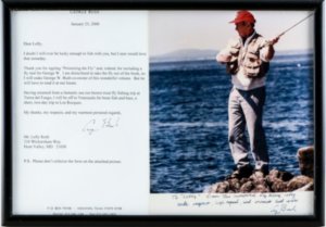
Kreh Auction Letter

Screenshot from LANGSAUCTION.COM

A dyed-in-the-wool fan of letters and photographs from famous people, I had my eye on a personal letter from President George H.W. Bush to Kreh thanking Lefty for sending Mr. Bush a copy of “Presenting the Fly”. According to the estimated price range, I felt my $100 bid strong enough to scare off the tire-kickers. Turns out, I was the tire kicker. The photo and accompanying image went for $650. And nearly everything else I’d found interesting shot straight through the estimates, leaving my bids ‘way down on the live bidding lists.

My abject failure to get close on anything, quickly had me checking into lure collecting. Turns out I was (again) a victim of my own ignorance. There are several levels of lure collecting – and I was out of my league.

A legendary figure like Lefty Kreh didn’t just have significant fishing tackle, he invented a bunch of it. That’s why the “Lefty’s Deceivers” in this auction sold in the hundreds – or higher. And those collections of lures with the hand-drawn “Plate A, B,C, etc” notations were worth so much. They were the lures for the illustrations of the definitive books on the tackle.

As I watched the auction rolling along, I realized many of the items weren’t antique- that’s a designation serious collectors only attach to pre-1900 lures. They weren’t the old, rusty, greasy lures left in the bottom of your grandfather’s ancient tackle box, either.

These lures were the “heroes” of their genre- the lures kept in pristine condition, accompanied in many cases by their original packaging and in “unfished” condition. They’d been used for catalogs, sent to notable writers (like Kreh) or given to serious collectors.
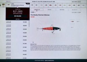
Kreh Muskie Charmer


Before this weekend, I don’t know if I’d ever heard of a Musky Charmer. But after this one sold for $21,000, I’m not likely to forget it, Charmer Bait Company, nor the Creek Chub Bait Company of Garrett, Indiana. Screenshot from Lang’s auction.

Researching over the weekend, I scratched the surface on a whole new category of angling- the lure collectors. The people who can look at an old lure and instantly recognize its parts, paint scheme, and likely year of manufacture. To them, it was about the art of the lure, not its allure to fish.

After all, the website www.antiquelures.com writes, “Antique lures have no real intrinsic value above five to ten dollars. For some collectors there is an emotional connection to our past or an individual we cared about when growing up with whom we associated fishing. There are those that love beautiful things that are old. But in the end, lures are historical artwork that was, in some cases, mass produced more than sixty years ago. There are plenty of old lures out there. But the real quest is for historical pieces or those preserved in new condition.”

Those were the people participating in this auction -and while I might share their love of all things old and exquisitely made, I lacked the baseline knowledge to know whether or not I was wasting my time bidding.

For me, the auction wasn’t about the things being auctioned, it was about my respect for the man who’d owned them last. To me, having something from Lefty would serve as a trigger for my memories of- and admiration for- him.

That’s why I was delighted to learn – after the fact- that I hadn’t struck out despite the fact I was fighting out of my weight class. Before the auction had begun, I’d bid on a piece that caught my eye because it didn’t look particularly historic.

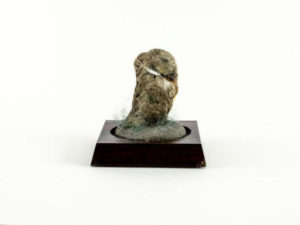
Kreh Mounted Stone Fly


A mounted Porter Stone Fly (above) with a base (below) that illustrates how revered “Lefty” was among fly fishermen. It will enjoy the same standing in its new home.

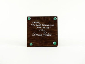
Mounted Porter Shrimp Fly from Kreh auction


Today, I’m the proud new owner of a “Mounted Porter Shrimp Fly” with a base that reads “Lefty, To Fish, Friendship, and Flies” and signed by its tyer, Bruce Porter. It might not be historic, but it will carry the memory of Lefty from one admirer to another.

That’s significant enough for me.

Oregon Working Landscape Project

Oregon Working Landscape Project
from The Fishing Wire

Construction Completed on Oregon Working Landscape Project Benefiting Farmers, Fish

Winter Lake Channels


Unique partnership of federal, state, tribal and local agencies, the agriculture industry, and environmental community worked together on a mutually beneficial habitat restoration project supporting salmon recovery.

Aerial view of construction of new habitat channels at Winter Lake. Credit BCI Contracting, Inc.

Partners representing natural resource, tribal, and agricultural stakeholders recently gathered in the Coquille River Valley in Oregon. They celebrated the completion of the Winter Lake restoration project, which will help ensure local cattle farmers continue to thrive. The project will also provide almost 8 miles of tidal channels and 1,700 acres of habitat for the threatened Oregon Coast coho salmon, and other fish and wildlife.

Habitat restoration and agriculture are often considered competing interests.This partnership between natural resource entities and agricultural landowners demonstrates that the two can benefit from a strategically planned project.

Cows Where Fish Will Be


Cows grazing on land that will be transformed to fish habitat in the winter.

Lowlands in and around the Valley’s Beaver Slough Drainage District are rich pasture for cattle, and are in high demand. In the past, levees were built, channels straightened, and acres of wetlands were filled to create agricultural land.

But the tidal gates managing water and helping keep the land dry for grazing started failing recently and had to be replaced. The Drainage District saw this opportunity to establish a new partnership to reimagine how water is managed there.

Their vision of “working landscapes” was to improve water control and protect the land from flooding during prime grazing season in the warmer months, and rebuild high-quality habitat for juvenile coho salmon in the winter.

Cute Sign


Where “we grow beef in the summer and fish in the winter.”

The project’s cornerstone is a set of new state-of-the-art tide gates that can better control flooding—allowing for seasonal use by agriculture, and fish and wildlife. The tide gates, working with reconnected channels and new habitat will provide the best of both worlds.

NOAA helped Beaver Slough Drainage District, the Nature Conservancy, Oregon Department of Fish and Wildlife and nearby land owner China Creek Gun Club develop plans for this comprehensive project. We supported it further with restoration and resilience grants totaling $2.7 million.

Water Control Project


Aerial view of the Winter Lake project’s new tide gates. BCI Contracting, Inc.

It is expected that the project could generate up to $3.4 million and 25 new jobs in the regional economy. It could then contribute an additional $3.2 million due to increased outdoor recreation spending over a twenty-year period.

Along the Pacific Northwest coast, wild salmon populations continue to decline. Like many northwestern rivers, the Coquille has lost much of its estuary habitat. Nearly 95 percent of prime salmon spawning and rearing waters there are gone.

Habitat restoration through innovative public-private partnership projects like this are the key to success. They eventually will assist in the recovery of salmon and other fish species critical to this region’s ecosystems and communities.

Remote Pond Survey Project

Maine’s Remote Pond Survey Project

Seasonal Technicians Chris Introne and Dan Perry haul in a gill net while surveying an Unnamed Pond
By MDIFW Fisheries Biologist Merry Gallagher
from The Fishing Wire

Doing a pond survey


The Department of Inland Fisheries and Wildlife Fisheries Division Native Fish Conservation Group completed another successful and perhaps the last summer of remote pond surveys in 2018.

Since 2011, MDIFW has teamed with volunteer anglers from Trout Unlimited and Maine Audubon to systematically survey pond habitats in Maine that had never been surveyed to assess fish community structure, determine basic water quality or aquatic habitat condition. When the effort began, almost 600 presumed ponds were identified from maps as having never been surveyed, but ‘the list’ was eventually pared down to 533 mapped features more indicative of ponds.

The Remote Pond Survey was set up as a two-step process – first, volunteer anglers with Maine Audubon and Trout Unlimited would visit a pond and by following a protocol established by all three partners (IFW, MA, TU) would record valuable information regarding how to access these remote ponds and also provide information on their fishing, such as species caught or detected, evidence of fishing activity occurring at the pond, and observations regarding habitat condition and water quality.

Old log structure


The remains of an old log driving structure on the outlet of Little Bog Pond.

These results provided by anglers contributed to waters being ranked for their likelihood of having wild brook trout populations or being coldwater fish habitat (Table 1) so that IFW biologists could concentrate our efforts on surveying waters that held the most promise for adding additional wild brook trout populations and their habitats to our roster of surveyed waters. The waters that IFW staff survey through a standard protocol estimates fish community structure, develops a basic map of the habitat, estimates pond depth and bathymetry, and measures basic water quality is phase 2 of the process.

Over seven years of effort, the volunteer survey ranked about 460 of the initial 533 remote presumed ponds with a Priority Code and referred that list to MDIFW for potential further action. Since 2012, MDIFW Fishery Biologists have been surveying remote ponds with Priority Codes of 1, 2 or 3. Although a large portion of this effort has been conducted by the Department’s native fish conservation group based in Bangor, regional staff have also conducted a fair share of these surveys and have assisted the Department’s native fish conservation group on occasion over the years.

Pond Brook Trout


Seasonal Technician Dan Perry with some wild brook trout sampled during a remote pond survey.

For the 2018 summer field season, the Department’s native fish conservation group staff conducted 46 remote pond surveys and we have added survey information to MDIFW databases for 196 waters total, of which 95 support previously undocumented populations of wild brook trout, since this effort began. We are thrilled to report that all ponds with a Priority Code of 1 or 2 are now completed and of the ponds remaining on the list, some are scheduled for survey in upcoming years by regional staff, most are ranked with Priority Codes of 4 or 5 and therefore do not likely warrant further effort, and less than 10 ponds with a Priority Code of 3 remain for consideration of future effort.

This has been a very large and dedicated effort by many! It was a monumental task to whittle a list of 533 unsurveyed presumed remote ponds down to a handful remaining in less than ten years. Without the dedication from the many volunteers, MA and TU, IFW staff and leadership, we would not be here today with a now largely completed Remote Pond Survey. Well done all!

Table 1. Priority Codes given to remote ponds based on Volunteer Angler Survey results
1 BKT caught by volunteer or present based on credible evidence
2 BKT possible, unconfirmed report, good water or habitat quality, etc.
3 BKT somewhat possible but not as likely as a Priority 2
4 Little to no expectation of finding BKT
5 Most likely will not be visited because of poor habitat, water quality, etc

Pond Headwaters Survey


Assessing the condition of an inlet to Little Mucalsea Pond as part of our standard pond survey protocol.