Category Archives: Map of the Month – Alabama

How and Where To Catch August Weiss Lake Bass with GPS Coordinates

August 2019 Weiss Lake Bass

with Hadyen Marbut

Rocks, docks, grass and bass. Lake Weiss is full of all four. Fish the first three in August for a good catch of spots and largemouth.

Weiss is a 30,200-acre Alabama Power Lake on the Coosa River. A small part of the upper Coosa is in Georgia, but an Alabama fishing license is required on most of it. The small mountains surround it will fool you as you drive to it the first time. The lake is flat and shallow, with huge stump filled flats except for the area near the dam.

The 447 miles of shoreline has rocky banks with seawalls and docks in some areas and flat banks with shallow grassbeds and docks in others. The lake has long been known at the Crappie Capitol of the World, but the same conditions that produce quality crappie fishing also produces good populations of Coosa spots and big largemouth.

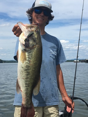
Hayden Marbut is a rising junior at Xavier High School in Birmingham and has been on the fishing team the past two years.  He is considering transferring to Briarwood Academy this year where Curtis Gossett is the fishing team coach.  Weiss is his favorite lake.

Hayden’s father, Brian, grew up 15 minutes from Weiss in Hokes Bluff and has been fishing Weiss all his life. He had taught Hayden how to catch bass there under all conditions.  Hot summer fishing can be tough on any lake, but Weiss produces good bass all summer.

This year, Hayden and his partner won the High School King of the Coosa tournament on Weiss and they came in third at the ASABSA tournament at Pickwick with 17.38 pounds, so his skills on Weiss transfer to other lakes.

“Weiss has a lot of big spots you can catch early around seawalls and rocks,” Hayden said. Grassbeds produce good largemouth early, too.  After the sun gets on the water the most consistent way to catch largemouth and some spots is to fish docks.

Fishing deep ledges and points is also good in August, especially if water is moving.  But the most consistent fishing is getting your bait in the shade under docks, and there are plenty of them to fish on Weiss.

For August, Hayden will have a Spook and a buzzbait tied on for early fishing around rocks. A frog works best in the many water willow grass beds for largemouth. For dock fishing, a jig and pig, Texas rig or shaky head is his choice.   He also has a Carolina rig and drop shot ready for trying for deeper fish.

We fished the following places in late June and the fishing was slow. It was hot and no moving water or breeze helped us out. But Hayden landed seven or eight keepers, including a 5.92 pound largemouth and a three-pound spot. His best five weighed 13 to 14 pounds, a good catch under tough conditions.

1.  N 34 11.348 – W 85 42.368 – Going upstream from Bay Spring, the upstream point of the second cove is a good rocky one that drops into deeper water.  It is a round point with a cement seawall and there are natural rock under the water.  It is a good place to start first thing in the morning.

Fish around the point, then jump across to the next one upstream.  It and the next one above it are all good and they get morning shade, keeping bass up shallow later in the day. 

Hayden get in fairly close to the point and cast right to the seawall ahead of the boat, working his bait back at an angle to keep it in close. His first choice is a big bone Spook, spots seem to hate it.  He twitches it back with a walk-the-dog zigzag action until it is near the boat.

A buzzbait is another good choice for fishing places like this.  Cast it against the seawall, try to actually hit it, and buzz it back at an angle to the boat.  Casts close to the bank are important since big spots will often seem to keep their nose against it and grab it as soon as it hits the water.

2.  N 34 14.231 – W 85 39.757 – Go into Little River behind Hog Island. If you are careful, you can go through the “Cut Through” on the downstream side of it but the channel goes in upstream of it and is safer.  Where the river narrows there are three islands on the left. A green channel marker without a number is on a post off them, marking where the old river channel swings to that side.

The lip of this channel for 200 yards on either side of the marker is a good summer ledge.  It drops from six to 25 feet deep and there are stumps and rocks on it.  Hayden will keep the boat in 22 feet of water and cast up on the top of the ledge and work it.  If you have time it is worth fishing the whole section or you can ride it with good electronics to look for fish.

Cast a Carolina rigged Old Monster or big lizard in black or plum tied about 30 inches behind a three-quarter ounce sinker and drag it until it falls off the ledge. Do the same with drop shot or jig and pig.  Current really helps here as does some wind moving water across it.

3.  N 34 14.217 – W 85 38.689 – Go to the double cove at Little River Marina (the old JR Marina) and fish the docks in both pockets.  Tournaments held here constantly “restock” the area, making the coves a high concentration place for bass.

Hayden especially likes old docks, those falling down into water seem to be bass magnets.  Docks on small points are also high value targets as are those with lights and pole holders, indicting possible brush piles.  Pitch a jig and pig, shaky head worm or Texas rigged creature bait to each dock.

Watch for angles and shade lines.  Work each pole on each dock.  Pay attention to where you get bit, bass in an area will often set up on the same places on other docks.  Hayden likes a black and blue Dirty Jigs Finesse Jig with a matching Rage Craw on it.

4.  N 34 13.806 – W 85 38.821 – Going out past the marina, on your left on the downstream point of the cove, an old roadbed runs off the bank and old bridge rubble is on it.  The roadbed runs out from a clay point with a pine tree on the end of it.

Keep your boat in 25 feet of water and cast up on top of the road about five feet deep.  Probe for the rubble and rough stuff on it, it is a fairly small area.  Work your Carolina rig, drop shot and jig and pig through the cover.  Hayden fishes an Aaron’s Magic Robo worm about a foot above a three eights ounce sinker on his drop shot.

5.  N 34 12.965 – W 85 36.477 – Run up under the causeway to the ramp at Weiss Mart on the left just upstream of the main bridge.  This is a similar place to hole three, with a marina that has tournament released fish around it.  Fish from the boat ramp all the way around the cove, working every dock.  Also hit the ramp, Hayden says he never passes up a boat ramp.

Hayden caught several bass in this cove, including a 5.92 pound largemouth and a three-pound spot.  He works each dock carefully and will come back to prime docks since they often reload quickly.  The big largemouth hit the second time we fished that dock.

Wind blowing into docks makes them better but harder to fish.  If the wind is blowing, fish into it for better boat control. Like the coves at Little River Marina, this cove has a channel in it.  Coves with ditches or channels giving bass a “highway” are much better than flat coves.

6.  N 34 11.190 – W 85 37.148 – Go across to the right side of the lake above the causeway.   The old river channel runs along this bank so it drops off fast. The docks from the causeway upstream are all good.

Current moving under the docks makes them much better, as does some wind.  Work against both if you can for better boat control, giving you more time to pick them apart.

Pitch a jig and pig, Texas rig or shaky head to them.  Hayden rigs a natural blue or green pumpkin finesse worm on a one quarter ounce head and tries to hit ever post until he finds a pattern. Outside post are often better and it is easier to land fish that hit on them but cast into the deepest shade you can hit with your baits, too.

7.  N 24 11.521 – W 85 37.685 – Go back to the causeway and fish the small bridge and riprap closest to the left bank going downstream.  If there is any current the bridge concentrates it and turns on the fish.

Hayden will fish all the rocks as well as the pilings under the bridge and shade lines from it.  Both spots and largemouth set up facing up current here so position your boat so you cast up the current and your bait moves back naturally with it.   A drop shot and shaky head work well for this but a small crankbait, worked slowly with the current, will catch fish, too. Make multiple casts to any spot you catch a bass; others are likely to set up there.

8.  N 34 11.433 – W 85 39.504 – Going down the left side of the lake, two small islands sit off the bank just upstream of Little Hog Nose Creek.  They are surrounded by water willow grass beds where bass feed. Early and late in the day are the best time to fish them, but bass will feed in them all during the day.

Start on the upstream point of the upstream island and cast your Spook, buzzbait and a frog through the grass.  A bluegill color Spro Popping Frog will allow you to fish the thickest grass.  Work the buzzbait and Spook along the edge and in cuts in the grass.  A silver blade Big Bite Baits Buzz with a Suicide Shad on it is his choice for buzzbaits.  Points on the grass are especially good.

9.  N 34 11.859 – W 85 40.101 – Out in the middle of the lake, straight between Little Nose Creek and Hog Island, green channel marker 20 sits on a good channel ledge. You can not safely run from hole 8 to it, you should go upstream and follow the channel around to it.

The top of the ledge is ten to 12 feet deep and drops into 25 feet of water.  There are stumps and rocks on it that hold bass, and the area right at the marker is very rough. 

Keep your boat in 25 feet of water and cast jig nd pig, shaky head and drop shot up on the ledge, dragging all three back and letting them fall.  Keep an eye on your electronics and fish your drop shot worm vertically when you see fish directly under your boat.

As in other places, current really turns on the fish here, making them feed, and wind blowing across it helps, too. Cast your baits up current for a natural action since current moves baitfish across the drop and bass expect food to be coming in that direction.

10.  N 34 11.932 – W 85 41.534 – The lake narrows down where Yellow Creek enters on the right going downstream.  Red channel marker 14 sits off the left point of the main river going downstream and there is a small island downstream of the point.  Docks along this bank are good.

Start at the first green roof dock and fish all the way down to the yellow boat house at the end of the line of docks. There is 18 feet of water not far off the docks and bass move from deep water to feed shallow around them. The pilings, shade and some brush piles all attract bass.

Current helps here and if it is moving, or if the wind is blowing, start at the end of the line of docks that gives you the best boat control.  Cast jig and pig, shaky head and Texas rig to them. Hayden lets his bait fall straight down. When it hits bottom, he shakes it a little then reels in for another cast.

These places were holding bass in late June, with some quality fish on them, and will be better now. Give them a try to see the kind of places you can catch summer spots and largemouth on Lake Weiss

Do you find these Map of the Month articles helpful?  If so visit http://fishing-about.com/keys-to-catching-georgia-bass-ebook-series/ – you can get an eBook or CD with an article for each month of the year on Clarks Hill and Lanier.

How and Where To Catch December Bass at Upper Bear Creek with GPS Coordinates

December Bass at Upper Bear Creek

with Gary Don Fleming

    December and big spotted bass go together almost as good as December and Christmas.  It may be the best month to catch a grown spot.  Upper Beaver Creek is a sleeper lake in North West Alabama that often gets overlooked but is full of big spots feeding this month.

    Formed in 1978 by a dam where Bear and Little Bear Creeks come together south of Russellville, this 1850 acre lake has a good big bass to little bass ratio.  Based on the 1995 to 2005 Alabama Bass Anglers Information Trail reports on all Alabama lakes, upper Bear has ranked first five times and second three times for the fewest number of hours it takes to catch a bass weighing over five pounds.

    The two arms of the lake are locally called Phil Campbell and Quarter Creek arms, with the Phil Campbell arm running mostly north and south and the Quarter Creek arm running more east and west. Both arms have bends and turns with smaller creeks and coves off them. The shape of the lake means it is a good place for a trip when the wind is strong since you can find protected waters to fish.

Gary Don Fleming grew up near Russellville and hunted the fields and woods that are now under water at Upper Bear Creek so he has a good knowledge of the terrain of the lake.  He fishes many tournaments in the area, qualifying for the BFL Regional on the Bama Division this year, and also fishes many local tournaments on Upper Bear Creek

He guides on the Bear Creek chain and Tennessee River lakes in northwest Alabama and also guides hunting trips.  His time on the lake and the knowledge he has of it can help you catch fish at Upper Bear Creek this month.

    “I was told Upper Bear Creek has the highest number of quality bass in the area second only to Guntersville,” Gary Don told me.  That confirms his experiences on the lake, where winter tournaments often take 30 pounds to win.  The highest weight he has seen weighed in there is 36 pounds. There are a lot of five and six pound spots and largemouth in the lake, and he knows of a 15.2 pound largemouth weighed in during a tournament there a couple of years ago.

    “In December the bass are holding on main lake structure and moving in to feed,” Gary Don told me.  They feed heavily as the water gets cooler and you can catch them on a lot of different baits.    A key is the presences of baitfish. If shad are in the area bass are likely to be nearby.

    Gary Don will have several rods rigged with a variety of baits for December fishing at Upper Bear Creek.  A buzzbait might surprise you this time of year, but he says he catches a lot of good fish on it on top, especially early in the morning.

    A red Rat-L-Trap is a good fast moving bait that works well here as is a small Bandit crankbait. Both will take active fish chasing shad and allow you to fish fast and cover water. A suspending jerk bait is a third plug he will have tied on and it will take slightly less active fish. 

    When he wants to slow down Gary Don keeps a jig and pig rigged up as well as a jig head worm and a Carolina rigged Baby Brush Hog. Those baits can be fished slowly and kept in contact with the bottom, even when it drops fast.  If the bass don’t seem to want to chase a bait it is a good idea to slow down and offer them something right in their face.

    We fished Upper Bear Lake in early November and the water was much higher than normal for this time of year. It was a tough day, with bluebird skies after several rainy days. And there was a full moon.  The lake should be back to normal by now and fishing will be good.

    The following ten spots will all hold good bass this month and you can catch them using Gary Don’s methods.

    1.  n 34 16.416 – w 87 41.235 – The big island between the two arms of the lake right where they join just above the dam has a long shallow point with a roadbed on it crossing the mouth of the Quarter Creek arm.  There are pole danger markers running from the island across to the far bank and you should not try to run through here, especially if the water is down any.

    Bass hold from the point on the island all along the roadbed and drops on the downstream side of it and feed on top.  Gary Don will fish from the end of the island across the roadbed, keeping his boat on the dam side and casting across the shallow water.

    He often starts with a topwater bait like a buzzbait here, especially early in the morning. The day we fished he got a keeper largemouth on a topwater plug but says he has more confidence in the buzzbait in December.  Work it all the way across to the other bank and down that bank to the first point.  There are a lot of stumps on this bank.

    Also work the top of the point and roadbed with a Rat-L-Trap and a jig and pig.  Cast across the shallow top and work both baits back to the boat in deeper water.  When you get to the far bank probe for the stumps with your jig and pig.  Big fish often hold and feed around them.

    2.  N 34 16.412 – W 87 41.61 – Run to the dam and stay to the left, toward the water intake tower. Start at it and fish the riprap out to the point above the spillway. Be careful, this is an overflow spillway and there is nothing to stop you from going over the dam, and the current can be strong here.

    Gary Don says you could fish this area all day and catch fish.  If there is any current on the lake at all it will be on the point here.  Work your jerk bait and crankbait, casting to the rocks and fishing them out. When you get out to the point go across toward the far bank. There is a shallow ledge running across the mouth of the spillway going to the dam and big rocks on it hold bass, too.

    Go back over the same area with a jig and pig or jig head worm. Use a fairly light bait to get hung less often in the rocks.  Cast up shallow and work the bait back.  Between the point and the intake tower you will be in deep water but it is shallow out near the point.

    3.  N 34 16.177 – W 87 40.577 – Run up past the long point with the campground on it, keeping to the right and go up the Quarter Creek arm.  The first creek on your right, across from the campground, is not real long but the left side of it going in holds good fish in December.

    Start at the two big pines standing with one old dead pine leaning at a sharp angle on the bank.  There are stumps and rocks all along this bank so fish it with your buzzbait and then cover it with a jig and pig.  Gary Don likes a football head jig with a Zoom Creepy Crawler trailer on it and works it on the bottom here.

    Fish back until you stop feeling rocks and stumps. The back of this creek is silted in and bass usually do not hold far back in it in December.

    4.  N 34 16.806 – W 87 40.275 – Run up the creek above the power lines that cross and to the sharp horseshoe bend back to your right.  As you go into the bend ahead of you on the left bank going upstream are two small coves. Start on the upstream point of the second one and work up the creek.  This bottom here drops fast to very deep water and is rocky. You will be sitting in 25 feet of water a very short cast off the bank.

    This is a good area to slow down and bump a jig and pig or a jig head worm down the rocks. You have to fish slowly since it drops so fast. Gary Don likes a green pumpkin finesse worm on his jig head and a one-eight ounce head will get hung less than a heavier one.

    Fish up the bank until you quit feeling rocks, about 75 yards.  The bottom will change to sand and Gary Don will sometimes run this bank with a crankbait. Fish it fast to see if the bass are holding on the sand rather than the rocks.

    5.  N 34 17.808 – W 87 39.533 – Head on up the creek and you will pass several houses and docks on your the left bank. Across from this area is a rock cliff that area with danger markers around it. It is an old coal mine.  Further upstream you will see a point on your left and the tin roof of a house up on it in the trees.  Stop on the downstream point of the cove downstream of the point with that house.

    Fish a Carolina rig and a Trap across this point at all angles.  Fan cast and cover it from downstream then work around it casting toward the bank, continuing until you are casting across it from the upstream side.  Since there is little current here the bass may position anywhere on the point.

    There are several points in the area similar to this one and all will hold bass.  As you leave the point you will see exposed rock on your left and there was a waterfall coming off it when we were there. A brick house is on the next point.  The water in this area was very stained from the rains when we were there but should clear up quickly.

    6. N 34 17.180 – W 87 41.078 – Going up the Phil Campbell arm of the lake, go under the bridge near the dam and the main lake will swing around a point and go off to your right. A small creek enters on the left and runs up parallel to the main lake.

    Start out on the point between the creek and main run of the lake and work into the creek. Stay way off the bank and make long casts with a Carolina rigged finesse worm or jig and pig.  Gary Don says this is a good place to get a limit of fish or to fill out a limit since it is very consistent.

    There are brush piles along this bank that hold bass so slow down and work it when you hit one. Gary Don likes a football head jig with the Zoom Creepy Crawler trailer on it and will crawl it along the bottom probing for cover, fishing it much like a Carolina rig.

    You can continue fishing on into this creek, working the bank and small points along it. Don’t leave as long as you are catching fish.

    7.  N 34 8.164 – W 87 40.632 – Running up this arm of the lake you will go by a broomstraw field on your right.  When you get where you can see houses way ahead of you, with yards down to the water you will also see a rock ledge running into a cove on your right. Across and just downstream of this ledge you will see a double point on your left.

    Gary Don says this point comes out pretty good and drops off fast. There are stumps on it and you will see an old logging road enter on the downstream side of the downstream point. Fan cast both points with your jig and also try a jig head worm here. Cover all of both points.

    8.  N 34 18.470 – W 37 40.504 – Run on up to the point just downstream of the big brick house on with a nice yard running to the water. There will be a big shallow cove between the point you want to start on and the point the house is on. Both are on the left going upstream.

    Work all around this point, sitting out in deep water and casting across it at all angles.  There is a big brush pile on the downstream side of the point and more brush scattered around on it.  There are also rocks here.

    Fish a jig and pig or jig head worm on the point, probing for the brush and rocks.  Work slowly around the point. It drops off fast and if you fish too fast you will miss the brush. Also watch your depthfinder for brush way out off the point and fish it, too.

    Gary Don say this they call this the Five Points area and there are five points here you can fish. All of them are good at times and they have hard rock bottoms. He says this is the best area on the lake.  Try them all.

    9.  N 34 19.210 – W 87 40.154 – Head on upstream and you will see a high rock bluff on your left.  Stop on the upstream point of it and fish that point into the cove to the dock.   Fish all around the dock, too.  A jig or a Carolina rig is good on these points and there are stumps and rocks on it to hold bass.

    10. N 34 39.944 – W 87 39.217 – Just downstream of the next bridge and boat ramp is a creek on the left side called Gas Branch. A small island sits off the bank on the upstream side of it.  Fish all around the island then work up the bank all the way to the boat ramp on the next point. Gary Don says many tournaments are won in this area.

    Fish all your baits. Try crankbaits and jerk baits then work the area with a jig and pig, Carolina rig worm and jig head worm. Fish the swimming area as you go by.  If you catch fish continue to work the area, switching baits and giving them a choice.

    These ten spots all hold good bass this month and there are many others like them all over the lake. Check out these and learn how Gary Don fishes them, then try to find similar spots to fish where you can work the pattern.

    You can contact Gary Don for a guide trip at 256-627-2903 or email him at garydonfleming@gmail.com

When Where and How To Catch November Bass at Lake Martin

November Bass at Martin
with BJ Barnett

November is a wonderful month for bass fishermen. The cool water has the bass active and feeding and the lakes are not crowded. It is a fun time to fish. Lake Martin, full of hungry spots and largemouth, is a great place to spend some time right now.

Lake Martin is a 39,180 acre lake with 700 miles of shoreline and is located on the Tallapoosa River near Alexander City. It is a deep, clear lake full of rocks, docks, humps, brush piles and spotted bass. There are also lots of largemouth in the lake. You can find just about any kind of fishing you prefer somewhere on the lake.

Dammed in 1926, Martin is an old lake and much of the natural cover has disappeared over time. Fish now relate to rocks, stumps, drops and man-made cover like docks and brush piles. It is also a very clear lake and bass can be spooky since they can see you far away.

B. J. Barnett grew up on Lake Martin. Until he was eight years old his family had a cabin on Blue Creek then they moved to a house across the road from Bay Pines Marina full time. At 11 years old he was putting his 16 foot Fisher boat with a 25 horsepower Johnson in at the marina with a 4-wheeler and fishing every chance he got.

After earning a fisheries biology degree at Auburn B. J. returned to the Alexander City area and worked with his father – and fished. He competed in local tournaments as well as the BFL, making the All American in 2005. He has a top ten finish in the Stren Series on Martin and fishes the BASS Weekend Series in the area.

Now B. J. owns Fish Tales Bait and Tackle in Alexander City. He is running a new tournament trail with Bay Pines Marina and also helps out with charity tournaments when he is not competing in them. He considers Martin his home lake and keeps up with what the bass are doing there.

“Bass will feed in shallow brush until the water cools below 60 degrees, usually around the first of November,” B.J. said. There is a lot of brush around docks in shallow pockets and the bass will be there, but as the water cools it also drops and both make the bass move to a more consistent pattern.

This year the water has been unusually high from the rains in late September. That may keep the bass shallow a little longer. But soon they will move to deeper banks and humps and hold on stumps, rocks and man-made brush piles. They will feed there, fattening up for the winter.

B.J. keeps his tackle fairly simple. He will always have a Sammy tied on and expects to catch bigger fish on it. In the past five years he has landed three spots weighing over six pounds each on the Sammy and one of them came last fall. It is especially effective on calm days when there isn’t much ripple on the water.

A spinnrebait is B.J.’s go to bait and he likes the Davis Pro Vibe X-Wire and he is also having good luck with the newer Hole Shot spinnerbaits. The Hole Shot has holes in its blades and it can be fished faster without breaking the surface. Both spinnerbaits have silver blades and white skirts and he likes a fairly big three/eights to one half ounce bait.

Spinnerbaits are best on windy days when there is a chop on the water. He makes long casts and works them fast over any cover in the area. Spinnerbaits will pull bass, especially spots, up out of deeper water to hit it. He fishes them on 12 pound fluorocarbon line.

A three sixteenths ounce Tightline Wood Thumper jig or a Davis jig rigged with a Paca Chunk in greens and browns is another good bait. Both jigs are compact and B. J. throws them around rocks and wood cover. Both are fished on PLine Fluorocarbon line. Bigger bass also like the jig and pig.

A Davis HBT Standup Jig head with a T-Mac or finesse worm also works well when the bass want at thinner bait. It is more subtle than the jig and pig and will get bites when other baits fail.

All these baits are available at Fish Tales and B.J. also pours his own line of jigs called Nervous jigs. They work well on Martin, too.

B.J. showed me the following ten spots in early October, right after the heavy rains. The lake was about a foot low and the fish were scattered. The lake is dropping pretty fast and by now they will be more concentrated and you should be able to catch them all month long on these holes.

1. N 32 50.522 – W 85 52.687 – Bay Pines Marina caters to fishermen and is a good place to put in for the spots B.J. likes to fish. If you put in there you can idle around the first point to your left as you come out of the cove the marina is in. You will be going into a big bay with a small island in the back near where it splits with a grave yard on it.

As you round the point watch for pink stucco and brick house on your left. Start just past it at the gray block boathouse. Stay way off the bank. There is a row of stumps in about 18 feet of water at full pool you want to fish over. The stumps will be more shallow as the lake is drawn down, and this is a good example of the kind of place the bass pull out to as the water cools and drops.

Blind cast with your Sammy if the water is smooth or your spinnerbait if some wind is blowing in on this bank. Work down the bank to the dock on concrete posts and look for brush. There is a lot of brush around this dock and it holds bass. Run your Sammy or spinnerbait over it then fish through it with a jig and pig and a jig head worm.

Fish on down past the dock to the little pocket and seawall coming out of it. There is scattered brush all along here you can hit if you probe for it, and spots especially like this area.

2. N 32 50.843 – W 85 52.268 – Toward the back of this big bay on your left before it splits you will see a danger marker way off the bank. It marks a rock ridge that runs way out off the bank from a small island near the bank. It is a very good feeding area for spots.

Keep your boat out in 15 to 16 feet of water and make long casts across the top of the ridge with a Sammy and a spinnerbait. Wind controls the bite; bass will hit the spinnerbait better if wind is blowing in on this spot. Wind always makes a place better, creating a ripple on top that makes it harder for the fish to get a good look at your bait and creating current that moves baitfish. Fish your bait with the wind, casting into it, on this spot and all others when there is some wind.

Work around the ridge, concentrating on working the wind. The downstream side is usually best. Also, watch for fish following your bait and not taking it. B.J. says sometimes you have to convince them to hit. Back off and make longer casts and also try other baits. If you see fish you know they are there, you just have to find the combination they want.

Also try a jig head worm here before you leave. Stay out in deep water and cast it up on top of the ridge. Work it around the rocks on this ridge, fishing from shallow to deep.

3. N 32 51.603 – W 85 50.830 – Run to the back of Madwind Creek to where it splits. Ahead of you will be two big houses with nice yards on a point and there is a small cove to the right of them. On the right side of the cove is a smaller house with a gray tin roof. In the middle of that small pocket, about even with the points on both sides, is a hump that rises to 12 feet deep at full pool. If the water is down five or six feet you can see it. The water drops off to 20 feet deep all around it and bass pull out on it as the water level and temperature drop.

Fish all around this hump with all your baits. There are logs and man-made brush piles on it so probe for them. When you find one work it hard from several angles with a jig and pig and a jig head worm. This spot holds largemouth and spots.

4. N 32 51.518 – W 85 50.901 – Across the creek on the left bank going in, about even with the point and hump, is a ridge running down the bank. There is a big sandy flat point between the bank and the ridge that drops off into the creek channel. The top of the ridge is just a few feet deep and you will see some brush sticking up out of the water from at least one of its brush piles. The channel drops to 20 feet deep.

The flat and point are in front of a gray house and there is a small pocket downstream of it. Keep your boat out in 20 feet of water and cast up into the shallows with your baits, working them back out over the drop. There is a good bit of brush and some rocks along this drop to fish.

5. N 32 50.019 – W 85 51.537 – Run out of Madwind Creek and stay near the left bank. Near the mouth of Manoy Creek is an island with a pirate flag flying from a tree. There is a sign on the tree warning “Ye Who Enter Beware” and some decorations like a fake cannon, skeleton and chest. This island is near a smaller island.

A ridge runs off the lake side of the island and is 17 feet deep on top well off the bank. There is 40 feet of water on either side of this ridge and it has stumps and brush on it that holds bass. Wind really helps here and a spinnerbait is your best bet when the wind is blowing in on it. Fish all round it from different angles, working the wind, with all your baits.

6. N 32 49.953 – W 85 51.014 – Go into Manoy Creek and it makes a hard left. The point is rocky and so is the bank for a good ways, then it turns to clay just past a small pocket. Out from this transition, well off the bank, is a hump with brush on it. It was an old state brush pile at one time but the marker is gone and fishermen have kept the brush fresh.

Say way off the bank and watch for a light color marking the top of the hump. You could barely see it the day B.J. and I fished but it should be more visible now. It tops out about four feet deep at full pool. The brush is on the deeper side, away from the bank.

Make long casts and work the hump and fish over the brush with Sammy and spinnerbait. Then probe for more brush with either of your jigs. The day we fished B.J. got a solid 2.5 pounds spot here on a spinnerbait and two bigger fish were following it.

7. N 32 50.270 – W 85 50.887 – If you follow the bank on straight ahead it runs into a small creek right where the main creek bank turns sharply to the right. Going back into this small creek there is a little pocket on the right bank. On the upstream side of it is a big tree in the water. Past the tree there are a lot of stumps, some of which you can see but many others underwater on the clay bottom.

Start at the small pocket and work into the creek. Fish faster-moving baits first then go back over the area with your bottom bouncing baits. Probe for the stumps and there is some brush here to hold bass, as well as the big blowdown and some smaller logs.

8. N 32 48.504 – W 85 52.061 – Come out of the mouth of Manoy Creek and head toward the mouth of Sandy Branch. Stay near the left bank. About half way between them, off the rocky point that runs out a little more than the others in this area, there is good hump. The point is in front of a pocket that runs back as a small angle almost parallel to the lake rather than straight back from it.

The hump is 13 feet deep on top at full pool and drops off to very deep water. It is big, about 50 yards wide, so you have to find the sweet spot on it. Look for where it drops fast from 12 to 20 feet deep on the lake side. This spot holds some big spots and B. J. says a four to five pounder is a good possibility here.

Slow down for the big fish and work your jig and pig down the drop. Sit on the lake side in deep water and cast up on top of the hump. Work your bait slowly down the drop, out to about 20 feet deep. Try different things. Drag your jig and pig on the bottom on one cast, then hop it on the next. Try to make the big spots that live here hit it.

9. N 32 48.031 – W 85 52.725 – Across the mouth of Sandy Branch off the upstream side of Pace Peninsula there is a small pocket with a danger marker on a pole out in the mouth of it. This big sandy hump doesn’t have much cover on it and it does not have a sharp drop, but if the wind is blowing in on it like it often does fish will be feeding here.

Fish from the left side of the marker facing it out to where it gets deeper then work the back side of it, too. This is a spot to fish fast and cover quickly. If the wind had fish feeding here you should catch them quickly. B. J. says you are wasting your time to fish this spot if there is no wind, but it can be real good with some wind.

10. N 32 48.048 – W 85 53.893 – Run across the lake and downstream to Wicker Point, the big rocky point straight across from Pleasure Point. There is a danger marker on some big rocks on the upstream side of the point near the end of it. A green cabin with a screen porch all around it and a block chimney sits on the bank behind the big rocks. There is a dock with pipe post near the danger marker, too.

Fish all around the big rocks you can see, and work the area for other rocks under the water. Fish around the dock for bass holding in the shade under it. This is a good place to catch spotted bass. B.J. says he will hit this point and the next five points going in toward New Hope ramp like this, hitting them all fast for active fish.

Give these spots a try. B.J. has found them by spending many hours on the water, but there are many more like them in the area that hold big bass. Try his tactics and baits and you will catch bass.

Where When and How To Catch August Bass at Smith Lake

August Bass at Smith with Don Hubbard

     It’s hot, lakes are covered up with skiers and jet skis and the fish just don’t bite very well during the day.  So what should the smart bass fisherman do? Go at night!  It is cooler, the fish feed and pleasure boaters are at a minimum.  Smith Lake is a great choice for night fishing right now since its big spots are feeding in the dark.

     Lewis Smith Lake, usually just called Smith Lake, is a few minutes west of Cullman and about an hour north of Birmingham.  It is a beautiful mountain lake with steep rocky banks covered with trees and nice houses. But it gets very crowded in the summer and most bass tournaments are held at night.  There are several pot tournaments held there each week starting in the late afternoon.

     Smith was filled in 1961 and has 21,200 acres of clear water and 500 miles of shoreline.  There has been a problem in the past with overcrowding of small bass so the size limit now a little unusual. You must release all bass from 13 to 15 inches long.  Not only can you keep any size bass shorter than 13 inches long, the fisheries biologists recommend keeping all bass under 13 inches long. So if you want a few bass for a fish fry, you can keep the smaller bass. Smith is a very clean lake so they fish taste great, too.    

     The slot limit seems to be helping. The most recent electro fishing survey in 2007 showed 16 percent of the bass are over the 15 inch size limit. That is an improvement over the 2003 survey.  Spots have done better under the slot restriction, with a greater increase of spots over 15 inches than of largemouth over that size.  Local fishermen have taken to the slot limit and it is common to hear them refer to the days catch with something like “five over and ten under.”

     Smith can be a tough lake to fish.  It ranks last in the 2007 BAIT survey for percent success of anglers. But it ranks much higher, at 7th, for average weight of bass and tenth for the average time it takes to catch a bass over five pounds. Smith bass may be hard to catch but when you do find them you are more likely to catch a good one.

     Don Hubbard lives in Cullman and has fished Smith since 1975.  He fished with the Cullman Bass Club for a time then started concentrating on bigger tournaments. For many years he fished three night pot tournament every week on Smith during the summer.  He loves bass fishing and enjoys the competition of tournaments.

     In 1990 Don and his partner won the Anderson Boat Works tournament on Smith with five spotted bass weighing 23 pounds. For years the Anderson Boat Works tournament was the biggest in the state, drawing over 500 boats each year.  Not only did Don and his partner win it in 1990, he has finished in second place four different times over the years.

     Don weighed in a 7 pound, 2 ounce spot in a tournament but it is not his biggest from Smith.  One winter day while fishing alone he landed a 27 inch fish he estimates at over nine pounds.  He did not have a scale to weigh it and wanted to get it back in the water so it would survive and did not take it somewhere to be weighed.  He has no doubt there is a record spot in Smith.

      “Bass are deep in Smith in August,” Don told me.  He looks for schools of fish down 15 to 30 feet deep this time of year and expects most of his catch to come from water 18 to 20 feet deep. That is where they feed.  And he expects the bite to be much better after the sun sets. Even on days the boat traffic doesn’t make fishing uncomfortable, the bass just don’t bite very well with the sun up.

     A variety of kinds of structure and cover pay off for Don this time of year.  He likes humps, points, steep banks and deep brush piles around docks.  Cover like brush, stumps and rocks help on all kinds of structure and a hump or point will often have a small sweet spot where there is good cover.  Finding the structure that holds a school of bass and the sweet spot where the biggest ones can be caught takes time on the water.

     Don keeps a variety of baits rigged on his Shamino rods and reels.  A big spinnerbait is his favorite bait when fishing after dark for tournament fish.  He does not mind fishing for five bites during tournament hours if they are the right bites. He has fun catching all size fish but concentrates on the big ones to win a tournament, and a spinnerbait is the way to go.

     A heavy home-made spinnerbait with a #5 Colorado blade is his choice for fishing deep cover.  Don likes a black blade, black and red skirt and big trailer on dark nights and a white skirt and silver blade bait on moonlight nights.  One trick he has learned about blade color may help you. If you are feeling bites but not hooking the bass, they may be hitting at the blade. Switch from silver to copper to get them to hit the skirt and hook.

     The trailer doesn’t make a lot of difference. It can be the same color as the skirt or a contrasting color.  And Don will use a variety of trailers like Zoom Brush Hogs, Toads and even lizards to slow the bait down.  He wants the bait to crawl along the bottom, ticking the cover, and a bulky trailer helps slow it down and keep it there.

     A three-quarters ounce jig and trailer is another good bait.  Don rigs the jig with a trailer that will slow it down and provide action, like a Zoom Chunk or twin curly tail grub.  He lets the jig hit the bottom, just like the spinnerbait, then slow rolls it along, ticking the cover, just like he fishes the spinnerbait.

     Don said his finesse jig was a half ounce jig with a smaller trailer. He may swim it or just hop it along.  He also uses a jig head worm, fishing it on spinning gear.  Green pumpkin colors for both baits are good if there is some light and Junebug or redbug are good at night. A Carolina rigged Zoom Fluke, Trick worm or Brush Hog and a Texas rigged worm completes his plastic arsenal. The Texas rig works better when fishing brush, especially around docks.

     Crankbaits will also catch bass on deep cover if you can get them to run deep enough.  Bass feeding at 15 feet can be caught on crankbaits when they are worked over the cover.  They are harder to fish deep than spinnerbaits or plastics, though.

     Don showed me the following ten spots he fishes at night and fish were on several of them a few weeks a ago, and will stay on them all summer.  Look for baitfish and bass holding deep and you can catch bass on these spots right now.

     1.  N 34 04.620 – W 86 58.134 – Leave the Smith Lake Park ramp and head downstream.  Look to your right just before the lake opens up to go around Goat Island and you will see some docks.  Look for the double decked dock with two picnic tables on the upper deck and lights on it. This is a good example of the kinds of deep brush around docks that Don likes to fish.

     If you look at a contour map you can see how the channel swings in near these docks then turns and goes across the lake. Don says you need at least 15 feet of water under the docks with the brush and deeper water just off them.  Lights at night will help.  

     This dock and the two downstream of it are all good and have about 23 feet of water under them.  Don will keep his boat out in front of the docks and cast past them and the brush, letting his spinnebait or a Texas rigged worm hit bottom. He then works the baits back across the brush. Jiggle and shake your worm in the brush.  Fish it and the spinnerbait as slowly as you can.

     There are many similar docks on Smith to fish. Look for them where the water is at least 15 feet deep with deeper water just off them. Brush is needed and lights help. Some docks that look good may not hold fish. The only way to find good docks is to fish them.

     2. N 34 03.903 – W 86 57.973 – Run down to the point on Goat Island that sticks out the most on the upstream end. Across and downstream of it a little you will see a small house trailer on the bank then a two story house with brown shingles. Out in the middle of the lake, about 200 yards off the trailer, is a hump that comes up to 20 feet on top. If you idle in a line from the upstream point on Goat Island toward the trailer you will cross it.

     This is a good example of the deep structure Don likes to fish.  The channel runs right by it and there is 45 feet of water a cast off the top of the most shallow part.  On this one Don likes to stay on the side toward the bank since it drops faster and he casts up to the top of the hump. He then brings his baits down the drop, fishing so slowly they stay in contact with the bottom.

     You can fish all the way around a hump like this but pay attention where you get the bites. Often the fish will orient a certain way on the humps and hold on a small spot of cover and you need to find what they like and repeat it.

     3.  N 34 03.443 – W 86 58.750 – Run downstream and watch for a blue top dock on your left where the river narrows back down after joining together below Goat Island.  A good ways past it you will see two small sycamore trees leaning out over the water and big rocks right at the water line under them. That is where you want to start fishing.

     Don’t fish the bank here, although it sometimes holds fish. Back off a long cast and you will find a hump or ridge that runs parallel to the bank. It swings out from near the small sycamore trees and then swings back in near the biggest tree you see up on the bank.

     Don will sit on the outside of this ridge and cast his baits across it, working them up the bank side then down the river side. It may look like he is fishing the bank with very long casts.  This is a good example of the kind of structure it takes a lot of time on the water to find and learn to fish.

     The day we fished there was a lot of baitfish and other fish stacked up in the trough between the bank and the ridge.  Although we didn’t catch anything there, the presence of fish tells you they will feed at some point. A place like this, where you find bait and bass on your depthfinder, is well worth repeated checks to try to hit it when they move onto the ridge to feed. That applies to all the spots Don likes to fish.    

     4.  N 34 03.036 – W 86 59.124 – Run downstream to the right bank across from the mouth of Simpson Creek. This steep bank has no houses on it on the upstream side and drops off very fast.  There are rock piles all along this bank as well as some brush out in 20 feet of water. It is the kind of bank Don likes, with dips and small points, not just a straight bluff wall.  He says some of his biggest bass from Smith have come off this bank.

     Start on the upstream end of this steep bank, near where there is a small point downstream of a cove. Fish on down the bank to the spot in number 5.

     To fish steep banks like this one Don keeps his boat in about 35 feet of water and makes angled casts to about 12 feet. Working his baits back at an angle keeps it in the productive 15 to 20 foot range longer than if you cast straight in toward the bank.   He probes for hidden rocks and brush in the 15 to 20 foot range while watching his deptfinder for fish holding even deeper. If you are seeing bass holding out in 30 to 35 feet of water, back out and work your bait at that depth to see if they will hit.

     5.  N 34 02.875 – W 86 59.58 – As you fish downstream on the bank above you will round a point and see a dock landing way up on the bank. The wind got the dock but the small deck where the walkway was anchored is still there. Just downstream of it is a big willow tree sitting in a small pocket.  A shelf runs out from this willow tree and is another of the kinds of hidden sweet spots Don tries to find.

     You can idle across this spot, staying parallel to the bank, and you will see the shelf come up then drop back off.  Fish get on top of this shelf to feed. Don likes to sit in front of the willow tree and cast downstream, landing his bait on top of the shelf. He then works the spinnerbait, or plastic down the upstream drop.

     Don says current does not play much of a role in fishing on Smith so he usually keeps his boat in deep water and casts to shallow water, working his bait down the drop. You are less likely to get hung up fishing in that direction, too.  You can fish all around this shelf and work your bait across it at different angles, but Don’s best luck has been casting downstream.

     6.  N 34 03.423 – W 87 00.720 – Start into the mouth of Millers Creek and you will see a shallow flat point running out on your right. Just upstream of the point there is a bunch of small willows or button bushes in the water. There is a red roof dock up on the bank on the upstream side of the point.

     This point runs way out and comes up into a hump. It tops out at about 15 feet deep then drops again into very deep water. There are stumps, rocks and man-made brush piles on this hump and point.

     Don likes to get out on the creek side of the hump and fish across it from this direction, but he will work all around it, casting at different angles.  Fish can be feeding anywhere on the point and hump but the bigger fish seem to concentrate nearer the deeper end.  Fish it with spinnerbait and crankbait, then try different plastics and jigs on it, too.

     7.  N 34 03.177 – W 87 01.055 – Across the lake going downsream you will see three danger markers in a line way off a point on  your left, across from the mouth of Miller Creek.  The river channel runs right along this point and it drops off fast on both sides. The ridge is very sharp and narrow and tops out at about nine feet at full pool   There is also a dip or saddle between the bank and the first marker out from it.

     Keep your boat out on the upstream side of the ridge and cast parallel, keeping your bait in the 15 to 18 foot range. Work the whole ridge, from the third marker out all the way into the bank. Don says bass often stack up in the saddle, too, so make some casts across it when you pass the marker closest to the bank.

     Bass will hold on the downstream side of the ridge, so it can pay off to circle it, fishing both sides. Wind blowing across this ridge will move water and position bass on it so work the wind. Don says wind generated water movement is much more important than any current here from power generation at the dam.

     Jigs and worms are Don’s best baits here and he will sometimes go to a Zoom Finesse worm on his jighead. It is better for numbers of bass but it will get bites when other baits fail.  Work it on eight pound line, fishing parallel to the drop in the 15 to 18 foot range.

     8.  N 34 03.193 – W 87 01.743 – Running downstream look to your right and you will see a series of coves and a small creek entering the lake as the river swings to your left. There are finger points between each of these coves that run way out and drop off into the channel. The ends of the points may be 17 to 18 feet deep then suddenly drop to 110 feet.   All of them can be good and all hold bass.

     Don usually starts out from a cabin that is all windows on the lake side.  There are several docks along here and there is usually an American flag flying on a pole.  If you start here and idle toward the big point downstream, on the downstream side of the deepest cove, you will cross the points.

     Since bass often school up on one of the points and several near it may not have many fish on them, Don will watch for bass and bait on his depthfinder.  Or you can fish them all, trying to find the schooling fish. There are sometimes single fish scattered here, too.  Keep your boat in deep water and cast across the points in 15 to 18 feet and work out to 30 feet deep here.

     9. N 34 03.134 – W 87 02.998 – Go into Lick Branch and you will see a long bank with a series of “For Sale” signs on it. There is one dock along this bank. Across from it, on your left, watch for a cove a little over half way back from the mouth to the split.  There are no houses on the bank from the cove upstream that you can see. The upstream point of this cove runs out and drops off and holds good fish.

     Ride over the point and you will see the bottom come up from 40 feet to about 16 feet on top.  Stay out on the end of the point in deep water and cover the whole point with your baits.  Don says he has caught a lot of good bass here.

     10. N 34 02.061 – W 87 02.909 – On the far bank, the one with the for sale signs, a ledge runs along the bank out then drops off into very deep water. Bass feed all along this ledge. If you get in close you can see small red lot marker signs on trees near the edge of the water.  Start near the #15 sign and fish downstream, past the dock and the small cove.

     Keep your boat out in 35 feet of water and cast parallel to the bank. The ledge runs out to 15 feet deep and you want to cover the 15 to 20 foot deep edge where it drops off.  Cast up into about ten feet of water and let your bait hit bottom, then fish it back so it stays on the bottom out to at least 20 feet deep.  When you get to the dip in the bank fish the edges of the dip where the ledge drops there, too.

     These spots are holding bass right now. Get on the lake before dark and find them and others like them, and fish them hard from sundown on.  Bass will bite all night long if you can stick with them.

How and Where To Catch April Bass at Lake Wheeler with GPS Coordinates and Lure Selection

with D.D. Murphy

    May is a transition month for bass, especially on northern Alabama lakes. The bass are moving and you have to follow them to have good catches.  But they do travel on predictable paths and they hold on predictable spots.  Wheeler is an excellent lake to pattern May bass and catch numbers as well as heavy sacks.

    Covering 60 miles on the Tennessee River, Wheeler is the second biggest Alabama Lake.  This TVA lake runs from the Guntersville dam to the Wheeler dam and goes from a river run to huge flats near Decatur to a highland type reservoir toward the dam. Dammed in 1936, it contains 67,000 acres of water and over 1000 miles of shoreline.

    D.D. Murphy grew up in the area and has fished Wheeler for 36 years.  As a youth he fished the lake with family members for anything that would bite. When he was 16 Coach Ronnie Hindman took him bass fishing on Lake Eufaula and he was hooked. Since then he has concentrated on catching bass and has learned Wheeler’s secrets.

    Owning a bait and tackle store in the area as well as fishing many tournaments on Wheeler helped D.D. figure out how to catch Wheeler bass. He has fished the BASS Weekend series the past two years and placed fourth on Wheeler last year and third there the year before.  His best tournament catch on Wheeler was a five fish limit weighing 28.12 pounds and he has landed a 9 pound, 15 ounce lunker from the lake.

    “Most tournaments are won on the flats between the nuclear plant and Limestone Creek,” D.D. said.  The big flats in that area produce heavy tournament strings and it is the area he fishes.  May is an excellent time to find schools of big fish moving across the flats and holding at the mouths of creeks.

    By late April 90 percent of the bass have finished bedding, according to D.D.  You might find a few still in the very shallow flats spawning but most are following ditches out to deeper water.  Find a bend in a creek channel or ditch and bass will be holding on it.  Points where the channels hit the main river also hold big schools of bass.

    The flats on Wheeler are very shallow, with two to six feet of water covering huge areas.  It does not take much of a drop to hold bass and give them something to follow. D.D. will watch for a change as little as six inches to one foot to know he is in a good place.

    Hard bottoms are a key. Shell beds are a favorite feeding place for May Wheeler bass. Those shell beds attract baitfish, the key to finding active bass on Wheeler.  Also, there will be some shad and bream spawning in May and they are attracted to the hard bottoms which brings the bass in to them.

    The flats and ditches have many stumps on them and bass love to hold around a stump.  That is also a good cover that D.D. searches for and if he can find a good stump bed near a shallow hump with shells on it he knows bass will hold there.

    A variety of lures will catch bass right now on Wheeler.  D.D. will have a Terminator spinnerbait, a Rapala or Strike King crankbait, a jig and pig, a Carolina rigged lizard and a Zara Spook tied on when he goes out.  All are thrown on Castaway or GLoomis rods and he uses heavy line, usually 17 pound mono.

    The water is usually stained at Wheeler but not muddy so shad colored baits are best and the heavy line does not spook the fish.  White with some chartreuse is a good color for the spinnerbait. In late April smaller blades work well but as May progresses and the baitfish get bigger he will go with bigger silver blades on his bait.

    Crankbaits that run ten feet deep or less are the best on Wheeler.  Most areas D.D. will be fishing may drop off to deeper water but he expects the fish to hit in four to six feet usually.  Shad colored crankbaits are the best for fishing this shallow water.

    D.D uses a homemade jig and tips it with a craw trailer.  Greens and browns are best in May. A jig and pig is his go-to bait for big bass. D.D. says more big bass have been caught on a jig and pig and more tournaments won on them than any other bait.

    He will also drag a Carolina rigged lizard and uses one-half to three-quarters ounce leads unless the wind or current is strong. Heavier sinkers help locate the shell beds and rocks as you drag your Carolina rig along but since the water is less than ten feet deep you don’t have to go to a full ounce sinker.

    The Spook is a great big-fish bait and chrome is a good color. It will draw strikes from fish holding at the depths D.D. likes to fish and a Spook walked over a drop with stumps on it will produce good bass.

    The following ten spots all hold May bass and are some of D.D.’s favorites. The GPS coordinates are in degrees, minutes and seconds.

    1. N 34 34 39.5 – W  86 53 13.4 – Creek mouths are good because bass migrating out of the creeks to deeper water will hold on cover and structure as they move out. But not all creek mouths are created equal.  Limestone Creek is a good example of the kind of structure you need to look for to hold bass.

    The upstream side of the mouth of Limestone Creek has flats and shallow water.  There is a river ledge that runs between the flats and the mouth of the creek, dropping off at the end into the creek channel and on the side into the river channel. This point is covered in stumps and is the kind of point or ledge that will hold bass.

    D.D. will position his boat in deep water off the end of the ledge, keeping it on the river side.  He will make long casts with his baits so they work across the point from different angles but always coming downstream.  You can work around the end of the point starting with one bait like the Spook then as you get into the creek side turn and fish back with another bait like a Carolina rigged lizard. That gives bass holding there a look at two different kinds of baits.

    If you catch a fish continue to work the bait it hits. After going some time without a bite try one of the other baits. Sometimes a change-up will get bites from fish that won’t go after the bait that has been working. Try to hit stumps with your Carolina rig and crankbait here.

    2. N 34 35 06.6 – W 86 55 32.9 – The mouth of Flint Creek is different in that it has more bends and flats on both sides with a river ledge on each side where it hits the main river.  Start at the upstream river ledge and fish it from several angles. It is best. Then try the downstream ledge.  You can also fish into the creek, keeping your boat in the creek channel and casting to the lips on either side.

    There is a sharp outside bend that swings over close to the bank not far into the creek.  Outside bends of channels always offer a hot spot where bass will hold up. The drop is usually sharper and it gives bass a quicker escape route.  Always watch for bends like this one and fish them carefully.

    Fish into the creek until you stop catching fish.  In late April and early May bass will still be filtering out of the creek and more may be back in it than later in the month. 

    3. N 34 38 31.7 – W 87 0 31.3 = Go downstream under the Highway 31 and railroad bridges and watch to your right.  At the second black channel marker buoy upstream of the Swan Creek Daylight Marker 302.3 slow down and idle across the river ledge. Watch your depthfinder and head straight toward the north bank.  You will be in shallow water about six feet deep or less but you will cross an old lake that drops into 11 feet deep.

    Start fishing as soon as the water drops off, working the lip of the old lake. Keep your boat out in the 10 to 11 feet of water and cast up across the flat, bringing your bait from shallow to deep. Fish all the way around the lake working like this. It will take some time to outline the lake bed but it can hold bass all around it.

    This is a pretty clean bottom with no stumps. There may be a little grass growing here. Milfoil used to fill the shallows and make the lake better but low winter pools have killed off most of it. If you hit any grass fish it carefully.

    This lake bed attracts lots of baitfish so watch for them. You will often see them skip away from your bait while it is in the shallow water and that is an excellent sign bass will be nearby. 

    Since the bottom is clean D.D. will often fish a lipless bait like a Rat-L-Trap here, one of the few places it can be worked without hanging up.  If he needs a bigger bass or is looking for tournament fish he will go with a big bait, starting with a three-quarter ounce and even fishing a full ounce Trap.

    This is also a good place to fish a crankbait, bumping bottom as you come across the lip of the old lake.  A spinnerbait slow rolled across the drop is also good.

    4. N 34 38 32.8 – W 87 01 28.9 – The mouth of Baker’s Creek is good but different.  Upstream of it the plant on that side has two water discharges so there is often current here even when the river is not moving.  There is a small island with trees on it in the mouth of the creek and flats on both sides of the channel. Where the creek enters there are rock piles on either side.

    Fish all around these rocks. Shad may spawn on them and bait fish are drawn to them. The current improves fishing here as it does on other spots but it is more consistent here due to the discharges.  Fish with the moving water as much as possible, keeping your boat on the down current side and casting back up and across the rocks.

    Current makes bass feed and you will often find it flowing over the points at the mouths of creeks. Current coming down the river and out of the creeks will create eddies that confuse baitfish and offer bass a good place to ambush them. Watch for any changes in the current if it is moving.

    5. N 34 39 11.6 – W 87 02 25.1 – Going downstream watch for the channel split where it goes on either side of Finley Island. The island is underwater but the shallows split the channel. Right at the head of the island, on the upstream end, is a red and green striped buoy marking the point of it.  This point is three to six feet deep and holds bass.

    D.D. will fish both sides of the point, positioning his boat downstream of the point out in the channel on either side and casting upstream, working his baits across the end of the point and down the sides.  You can throw a crankbait, spinnerbait, jig and pig and Carolina rig here, fishing with any current coming down the river.

    6. N 34 39 54.1 – W 87 03 28.4 – Across the river channel you will see Byrd’s Island Daylight Marker 299.3.  Go to it and fish the river ledge on both sides of it.  There are no ditches across it but there are shell beds on both sides that hold bass. You can feel them with a Carolina rig or heavy jig and pig to locate them and then fish all your baits over them.

    Watch carefully for any rise, even if it is only six inches.  This will often mark the shell bed so if you see your boat is coming up into more shallow water fish closer to it. You may be sitting on the sweet spot and casting past it.  If you do get your boat up on top of the shell bed mark it then come back later and fish it.  Your boat may spook the fish in the very shallow water but they will come back.

    7. N 34 39 26.5 – W 87 03 28.4 – If you go straight south across the channel from the marker in hole 6 you will cross the middle of Finley Island. When it gets shallow idle across the flat and watch your dephfinder.  The water will be three to six feet deep then suddenly drop off to 11 feet deep.  This is an old farm pond that was on the island and you can see it on good maps.

    Grass used to grow all around this old farm pond and hold fish. There are some stumps here and you may find a little grass now. Get your boat into the middle of the pond in the 11 foot deep water and fish all around it, casting your baits to the shallow water and working them back across the drop.   

    Here and other spots bass are more likely to be on the upstream side if the current is flowing.  They can hold in the deeper water in the old pond and baitfish coming downstream with the current will wash across the lip of the drop and make and easy meal. Try to make your crankbait or spinnerbait look like a baitfish coming downstream with the current.

    8. N 34 40 36.4 – W 87 03 17.2 – Several creek channels wind across the big flats in the mouth of Swan Creek and join up. There are also ditches off them and high spots on the edges of the channels and ditches.  Bass moving out of the vast spawning flats behind these ditches will follow them out, stopping to feed on bends and high spots.

    The mouth of the creek is between the marker in hole 6 and the power line but it is small and there are stumps here. Be very careful going it until you learn your way. You will be going across flats only two to three feet deep in many places and sometimes the deeper channels are lined with stumps. Idle speed is safer.

    Go in and find the sharp bend in the creek channel. It is due north of the downstream end of Finley Island, although a long way from it, and south of the big island in the mouth of Round Island, Briley and Mud Creeks where they all come together.

    There are two shallow humps just off the lip of this ditch.  Fish all around it and work up the ditches, following them looking for breaks and humps.  Bass will hold on any change and feed here.

    Your Spook is a good search bait here and in other places. Make long casts across the ditch edges and work it along them. A hit will usually mean other bass are holding in the same area.  Fish your Spook but also follow it up with crankbaits, spinnerbaits, jig and pig and a lizard.

    9. N 34 40 32.7 – W 87 04 27.2 – If you follow the creek channel downstream it will run between two sets of towers on the power line.  One tower set is out near the river channel and the next one toward the north bank and the ditch where two creek channels join and make a bend before going out to the river between is them.

    Fish the ditches like the ones in hole 8 but also fish the towers.  The concrete piers of the towers have rocks around them and often draw in schools of shad to spawn around them.  Fish all around the tower bases with topwater then run a spinnerbait or crankbait right beside the legs.  Stay downstream and cast upstream to work your baits with the current if it is moving.

    D.D. says a big tournament was won here by fishing these towers.  The channels are like a highway the bass follow and the towers are like fast food joints along the highway. Bass will hold and feed around them all during May.

    10. N 34 40 33.9 – W 87 05 51.6 – The mouth of Fox Creek offers flats on both sides with a channel snaking across them to join up with the river.  D.D. sits out on the river and throws across the upstream point formed by the creek and river channel, fishing a crankbait or Carolina rig across it.

    Dark lizards seem to be better and D.D. likes the Zoom lizard in either black or Junebug.  He will vary his sinker weight with the current but likes lighter leads when possible, unless trying to find new shell beds.

    Fish both sides of the creek mouth and work into it, following the channel across the flat, especially in late April and early May.  Search for schools of bass with faster moving baits then fish them and your slower moving Carolina rig and jig and pig for bigger fish.

    Try these ten spots then find others by studying a map looking for ditches and humps. Spend time on the water fishing those places. Try D.D.’s baits and tactics and you will catch plenty of May bass at Wheeler.

Where and How To Catch April Bass at Aliceville with GPS Coordinates

with Steven Fikes

     If you like fishing for shallow bass you love April.  All over the state bass are in the shallows either spawning or feeding after the spawn.  If you really like fishing for shallow fish around grass and lily pads you should head to Aliceville on the Tombigbee River.  Its backwaters are full of bass feeding around shallow cover right now.

     Aliceville, also called Pickensville by some, is an 8300 acre impoundment formed by a lock and dam on the Tombigbee River west of Tuscaloosa right on the state line.  The dam was closed in 1980 and water from the river filled many sloughs and shallows on both sides.  There a couple of good ramps and some lakeside campgrounds for visiting anglers.

     Many bass fishermen from both Alabama and Mississippi fish Aliceville and it hosts a good many club and pot tournaments. In the 2007 BAIT Program it ranked in first place for the bass per angler day and pounds per angler day categories.  Combine that with a third place ranking in percent success, fourth in average bass weight and second in hours per bass over five pounds and Aliceville got the top ranking of the 27 lakes in the survey.

     Steven Fikes has lived all his live around Tuscaloosa and loves bass fishing.  He grew up fishing and got serious about tournament fishing about four years ago. Up to that time he had fished with the Tuscaloosa County Bass Club and some other tournaments with buddies and as a no boater in some BFLs.  When he started fishing the BFLs as a boater he did well, qualifying for the All American in 2007 and qualifying for the BFL Regional again last year.  He is on the Grammer Marine fishing team and also fishes their tournament trail as well as other local pot tournaments.

     Steven fishes Aliceville often and knows what the bass are doing there.  He says many bass will spawn on the full moon around March 11 and another smaller wave will spawn on the April 9th full moon.  That means right now there are post spawn bass in the shallows guarding fry and feeding as well as pre spawn bass looking at bedding areas.  By mid April there will be some post spawn fish guarding fry but most of the bass will be feeding in the shallows through the end of the month.

     In an April Aliceville tournament Steven weighed in his best five bass limit in a tournament at 16.25 pounds and had a personal limit while “fun” fishing weighing 21.5 pounds.  His best bass from Aliceville is just under seven pounds but he has seen many bigger bass caught there.

     Aliceville is full of sloughs and shallow flooded flats covered with hydrilla, milfoil, lily pads and several other types of grass.  Some sloughs have cypress trees standing in water six to ten feet deep.  All this cover offers bass great places to hold and feed and makes the lake look “fishy” everywhere you turn.

     Steven is on the Castaway Rods fishing team and uses their casting rods in a variety of actions to cover the baits he likes to fish in Aliceville right now.  He will have a couple of heavy rods and reels spooled with Power Pro braid for flipping creature baits, lizards and jigs into grass and around trees.  He will always have a rod and reel rigged with a Zara Spook for fishing open water and a buzzbait tied on for heavier grass cover.

     A Strike King spinnerbait is ready to run around grass and cypress trees and he will also use a Bandit Footloose shallow running crankbait to fish over grass that is still under the surface.  A floating worm is also a good bait to have ready.  He uses Bass Pro Shops Excel monofilament line for baits where it works best and will go to Segar Fluorocarbon if the he needs an invisible line in clear water.

     Steven and I fished Aliceville the last day of February – the day after the flooding rains. It was cold and cloudy and the river was running as fast as he had ever seen it and rising all day, pushing water back into the woods. Muddy water was also pushing into the shallows but we were still able to find some clear water to fish, which is important and you can almost always find it even when the river is muddy. 

     Even under the bad conditions we landed 14 or 15 bass up to three pounds. Most looked like bucks moving in to check out spawning areas so by now many will have spawned and the bucks will be guarding fry and the females will be feeding to recover from the spawn in the following areas.

     1. N 33 16.264 – W 88 18.814 – If you put in at Raleigh Ryan Access ramp run up the river to the second opening to your right. It is not the opening at the red channel marker; it is past it and is one of the entrances to Coal Fire Creek.  Be careful since it is shallow and there are stumps here. You will go back and turn to your left as you follow the bank. There will be standing trees on your left and you want to go around to the back side of them.

     When you get behind the timber there are two good pockets on your left across the timber field. There are lots of stumps under water as well as visible ones and standing trees. Go in carefully to the cove on the left and start fishing near the blown down tree with the big root ball sticking up on the bank. Work to your right, fishing around this pocket, across the point between them and around the next cove, too. 

     Steven likes to start fishing early moving fast with a spinnerbait or topwater in areas like this. There will be lots of grass to fish and the bass can be anywhere in it. When you catch one, especially if it is a good one, slow down and probe the area carefully with a plastic bait or a jig and pig. Pitch them into holes in the grass and also rig one on a heavy tungsten sinker that will punch through the mats to bass holding under it. Work a floating worm over and through the grass, too.

     2. N 33 15.757 – W 88 17.587 – Coming back out the way you went in watch for an opening to your left. There is a big island to the left side and a very small island to the right of it.  Start fishing on the point of the big island and fish back into the slough to your left. There is a lot of grass and pads in here and it will get very thick toward the end of April.

     Out on the point the water comes up from 11 to six feet deep pretty quickly and the bass will hold along this drop in the grass.  It gives them access to deep water so this is a very good place later in April.  They can feed all the way back into the slough so work your spinnerbait, shallow running crankbait and topwater all around this slough.  We caught four bass and Steven caught one of our biggest bass here when we fished. The water was a good color although many other areas were muddy.

     Watch for open areas between grass mats and work your Spook through them. If that does not draw a strike try punching through the mats with a creature bait like a Little Chigger Craw or a lizard.  Be ready for a hit as soon as it falls through the mat and set the hook hard. You will need braid and a heavy rod for this kind of fishing.

     3.  N 33 14.825 – W 88 88.954 – You can go all the way back out the point of the main river where you came in or start working the bank to your left a couple of hundred yards before you get to the river.  A ledge with grass growing on it runs out from this bank then drops off fast and is a good area for post spawn fish.  Overhanging brush offers some shade, too.

     Run a buzzbait over the grass then work your plastics through it.  Keep your boat out in deeper water and fish the edges of the grass then work back into it. Here and in all other spots pick apart the cover if you catch a good bass, there are likely more nearby.  Watch for patterns, too. If you catch a couple of bass from milfoil but not other grass, concentrate on the milfoil.

     4.  N 33 15.122 – W 88 18.286 – For something a little different run up to the big grain bins up the river from the campground on your left. Start working the left bank, fishing the docks and riprap along this bank all the way to the barge landing. Fish around the barge if one is there.

     A spinnerbait or crankbait is good here and you can also fish a floating worm or jig around the docks. 
Fishing upstream gives you more control of the boat and also allows you to fish slower.  Work your bait with the current as you work upstream, presenting the bait naturally like a baitfish moving with the current.

     5. N 33 15.580 – W 88 18.985 – Run upstream and you will pass some houses on your left.  Just above the green channel marker 310.7 in front of one of the houses is the opening to a big creek. Run back in it to the small island on your right. It is across from a big house with a screen porch that runs all the way around it, the fifth house from the end.

     There is deeper water around this island and grassbeds fill the shallows near it.  Bass hold here both post and pre spawn because of this deeper water refuge and feed in the grass. Fish all the way around the island covering it with all your baits.  Steven says grass will often grow to within six inches of the surface out away from the island and you can work a topwater bait like a Spook or buzzbait over it to pull bass up out of the grass.

     6. N 33 14.385 – W 88 18.467 – Head back down the river and go into the creek at the upstream end of the campground. Stay near the left bank, there are two more sloughs to your right.  Steven runs back to where there are permanent trailers and docks on your left going in.  Many of the docks have white PVC post on them. The day we fished the docks were under water and the posts looked like they were just standing in the water.

     Fish up this bank, pitching a plastic bait under the docks and to the poles on them. Work the scattered grassbeds around them, too.  Steven will fish all the way into the cove where the road runs near the water and there is a private boat ramp. If any bass are still bedding some will be back in this cove then they will move out to the docks and feed post spawn. You can look for beds and sight fish back in here around the full moon in April.

     7. N 33 15.014 – W 88 18.660 – Come out of the left pocket and run into the middle arm. Go back until you get to the trailers but watch for stumps in that area. You will be back behind the grain bins out on the river. 

     Many of the stumps back here have PVC pipe in them to mark them.  There is a bed of a half-dozen or so stumps out from the trailers and Steven likes to work the grass all around them. Try to drop your bait down by the stump, too.  It will be covered with grass but offers a good holding spot in the grass. Fish all around the back of this slough, working the grass here.

     8.  N 33 15.308 – W 88 16.677 – Run down the river and go into the cut just upstream of the red channel marker 309.3. This is actually the old river channel and it runs to the far bank with houses on it.  Run almost to this bank then swing left, following the bank. You will run past some standing trees on your right. When the open water narrows down to a small channel ahead and to the right there is a big slough full of cypress trees to your left. Steven still calls this the Eagle’s Nest although the nest is gone.

     Steven stops out from these trees and works in, casting a Spook around them then flipping a jig and pig or plastic bait to the.  The trees are in six to ten feet of water and run a long way up this slough.  You could probably stay in here all day fishing trees.

     Also try your baits around the grass on the banks of the slough. Steven says you will often catch males guarding fry around the grass but the bigger females are likely to be holding deeper around the base of the trees, recovering from the spawn. Steven said if he had to catch a five pounder he would concentrate on cypress trees here.

     Fish trees slowly and carefully and try to find a pattern. Are they holding on the shady side of the tree? Do they want a splash when your bait hits the water or do you need to hit the trunk and let your bait slide into the water? Paying attention to details like those can make the difference between fishing and catching.

     9. N 33 14.708 – W 88 16.025 – Go back out the way you came in and when the trees on your left end you will see a big point on your right.  It is the right side point of a big cove when facing it.  Start on the point and work the grass beds going into this side of the cove.

     This is a very big flat and the grass will be all over it. Work all of the right side, looking for keys like where two kinds of grass come together or where there is an isolated patch on top.  Keep fishing the area until you find the fish then concentrate on the smaller area and pattern where they are holding. The other end of the slough full of cypress in hole 8 opens here and you can fish all the way through it and come out here, or go in here too.

     10. N 33 14.748 – W 88 17.319 – In the back of the big cove above you will see a small island toward the left bank going in and there is a opening to its left. This goes back then opens up. Another cut to the left goes into another pond that is called Clear Hole.  The water almost always stays clear in here. Steven says many people go in here looking for bedding bass but they get hammered and are hard to catch.

     Check out the ponds and cuts in this area. Steven says he often starts out at the small island at the first cut and is catching bass as other boats go by him further back to look for spawners.  Fish all the grass in the cuts and ponds in this area.

     Check out these ten spots.  There are many others near them that hold bass, these are just some of Steven’s favorites.  Once you find the patterns the bass are on and which baits they want you can catch them in other similar areas.

     Steven did not fish as hard as he wanted to last year. After some numbness in his left hand he was diagnosed with Multiple Sclerosis.  Fortunately, medication has stopped the progress of the MS and he is able to fish now. Please keep Steven in your thoughts and prayers.

Where and How To Catch February Bass at Demopolis with GPS Coordinates

with Boyd Duckett

     Bass fishing in February can be either feast or famine.  Cold fronts and harsh temperatures turn off the bass but a three day warming trend can herd the big bass to shallow area where you can catch them  better than any other time of year.  Improve your odds by heading south. Demopolis Lake is a good bet for February bass in shallow water.

     At 10,000 acres Demopolis is the largest lake on the Black Warrior/Tombigbee River system. It extends up the Black Warrior River 48 miles and 53 miles up the Tombigbee River from an overflow dam near the city of Demopolis.  Since it is an overflow dam and the land is very flat the lake can rise or fall quickly depending on upstream rains, and there are no controls on the water level.

     Demopolis offers tough fishing at times but the 14 inch limit means the average size of bass weighed in at club tournaments is good.  In the 2007 BAIT reports Demopolis ranked 17th in angler success but 5th in average bass weight. You will catch a lot of bass under the 14 inch length limit that must be released and are not brought in during tournaments.

     Boyd Duckett grew up in North Carolina and started fishing with his brother when they found a pond back in the woods near where they lived. He began tournament fishing when 17 years old and jumped in at the pot tournament level on local lakes. A move to Nashville, TN for business allowed him to learn fishing deep in highland reservoirs, a change from what he was used to fishing.

     In 1991 Boyd moved to Demopolis and within a few years his tournament fishing seemed to get a lot better with him winning many events.  In 2002 he got serious about his tournament fishing and entered bigger tournaments. That paid off in 2007 with a Bassmasters Classic win and he now fishes the Elite Series as well as the PAA events.  He will be fishing the Classic this month on the Red River after qualifying through the Elite Series.

     In 2007 Boyd set a one-season record, winning $860,000 that year, more than any other fisherman had won in one year on the BASS trail.  He was also the first fisherman in 36 Classics to win one on his home state lake when he won at Lay Lake that year.

      Boyd learned a lot about Demopolis fishing it in local tournaments with Bill Champion.  He agreed to share some of the keys to February fishing there and says water level is critical to catching bass in February.  If the water is rising from upstream rains the fish will move far back into newly flooded cover and you can not get to them.  Falling water pulls them to the edges and makes them easier to catch.

     Since Demopolis is so shallow Boyd says the bass will move to the spawning areas as soon as there are a few warm days and the bigger bass move in first.  They will head into sloughs and creeks, working their way to the very backs of them to spawn. You can follow them this month and use a variety of methods to catch them.

     Water clarity is very important, too.  Rising water forces muddy river water back into the sloughs and you need to go back in them until you find a good color to fish. Some are so long that muddy water almost never gets all the way back in them.

     Boyd will tie on a Berkley Little Chigger Craw behind a heavy Tru-Tungsten weight for flipping mats and heavy cover, a Rat-L-Trap for searching for active fish and a Falcon spinnerbait for covering water where the Trap is ineffective. He also likes a shallow running crankbait like the Mann’s 1 Minus to run over shallow grass back in the pockets.

     Boyd showed me the following spots a few weeks ago and fish were already in some of them.  They will get better all month as more and more bass respond to the warming water and move in.

     1.  N 32 31.159 – W 87 52.209 – Running upriver from the dam the second small ditch on your left runs back and opens up into a big slough that runs parallel to the river.  Boyd called this the “Meat Hole” because of all the bass caught in it.  When we were there the rising water had filled the ditch with hyacinths and it would have been hard getting in but Boyd says it is well worth the effort.

     The ditch going in is only about 2 feet deep with the river stage at 20.5 feet so you need it at least that high to get in.  When you get back where the slough opens up, there will be a lot of flooded brush and tree bases standing in the water. Boyd says to fish the first 5 feet of cover from the edge back, working it with a spinnerbait when you can and flipping or pitching a Little Chigger Craw tight to cover where it is thick.

     If the river stage is over 22 feet this spot and others gets very hard to fish since the water will be many yards back into thick woods you can’t get to. Bass follow the rising water and get where you can’t catch them.  When the level is between 20.5 and 22 this is one of the best places on the lake.

     2. N 32 31.920 – W 87 50.953 – Culpepper Slough runs off the right side of the river upstream of the marina and dock at Demopolis and goes back under Highway 43.   There is standing timber in the middle of the slough going in so be very careful. It is a good idea to idle in until you learn it.

     Go back to the bridge and start fishing. Bass will move up the slough and hold around razor grass, tree bases in the water and under matted vegetation. One of Boyd’s favorites is what he called “alligator grass,” a plant with small leaves on long stems. The roots are on the shallow side and the plant grows toward deep water, making a covering shelf bass love to hold under.  The plants warm from the sun and the water temperature will usually be several degrees warmer under the mat than in the surrounding water.

     Near the back of the slough on your right you will see the old causeway for Highway 43.  Fish all along the slough on both sides. There are lots of mats of grass to fish here.  Flip a heavy weighed Chigger Craw and let it fall through the mat.  Boyd says be ready, you can’t drop your rod tip and set the hook since the weight is so heavy. The fish will spit it out quick so set the hook on any tick or hesitation as your bait falls.

     Work all around this slough and go back as far as you can. You can’t go too shallow in February if there have been a few warm days. Hit all the cover you come to including grass mats, tree trunks and razor grass edges.

     3.  N 32 32.496 – W 87 50.947 – Run up past where the two rivers join and watch for an opening on your left.  The ditch leads into Dobbs Swamp, a huge area where you could spend all day fishing. As you go in the channel will split off to your left, the coordinates above are just upstream of that split going left.

     Start at the split and fish into the lakes and sloughs on that side, fishing open water with Rat-L-Trap and spinnerbaits and pitching a plastic bait to heavy cover.  Keep working back until you find clearer water if the mouth is stained up.  Here and in other areas river stages of 20 to 21 feet are best.

     Watch for old beaver dams across channels.  At high water they will be covered but most have grass and trees growing on them.  If the water is dropping and a current is moving across them the little cuts and channels with current always hold bass.  For some reason rising water creating a current on the upper side of them does not hold the bass but Boyd says you are guaranteed a bass if the water is dropping and you fish the current on the downstream side of them.

     4. N 32 33.126 – W 87 51.633 – Come back out and go up the right side at the split.  You can run a long way back in a narrow channel then it will end at mats of hyacinth. Push through it and lakes will open up on your right and ahead of you.   The one on the right is choked with hyacinth and the one a head is more open, with hydrilla in the middle.

     Both can hold fish but after warm days the one ahead will be better, and the water will be even clearer.  It was very clear in here the day we fished and individual bass were chasing shad. Boyd said two days before we fished, on a cloudy day, there was a lot of schooling activity here and he caught a bunch of bass. The day we fished he landed three fish on a shallow running crankbait fished slowly over the grass.

     In this and other areas, if the water is still in the low 50s Boyd will flip the edges of the razor grass beds with a Chigger Craw.  Bass will hold in these spots until it warms a little more. Also concentrate on the mats if the sun is shinning and the water is warming.  Bass are more likely to be active and in the hydrilla if the water is warming, too.  When it gets above 55 degrees Boyd will go as far back into these areas as he can, pitching to all the heavy cover.  He says you can not go too far back in February; the bass will be very shallow.

     5.  N 32 31.033 – W 87 49.004 – Run up the Warrior River until you see the cement plant on your right and an old rail road trestle running down the side of the river. It is being dismantled.  Go under it at the small ditch and a steep bank slough opens up.  The water in here is usually clear and it is deeper than any of the other sloughs in the area.  Boyd calls this the “Citadel.”

     Boyd says this is a good early February hole since the water stays clear and warms fast.  He will start just inside the slough and work all the way around it, hitting all the shoreline cover.  There is another ditch opening to your left not far from the mouth that is very good if the water is in the mid 50s and warmer.  It opens up into about an acre size lake and holds some big bass.

     6.  Run into French Creek, the big creek on your right above the cement plant.  It opens up and goes back to a bridge.  Run to the bridge and start fishing on the left side as soon as you go under it.  Fish all the way to where the bank turns back to the right at coordinates N 32 31.315 – W 87 47.331 or go to this spot and start fishing back toward the bridge.

     Boyd says this is a good early spot since it is a steep bank with a lot of wood cover along it.  You will see a metal gate running off the bank, too.  When the water temperature is 50 to 51 he likes to fish all along this 400 yard stretch, working the cover slowly and carefully. 

     Bass moving up will hold along this bank before moving on toward the back of the creek.  And French Creek tends to have bigger bass than most other areas so it is a good place to work during tournaments.  Florida strain largemouth were stocked from the bridge here for three years back in the mid 1980s and, although they have been diluted over time, their offspring still produce bigger bass than most other areas on the lake.

     7.  Go back to the bridge and start on the other side, the upstream side on your right going upstream.  Fish along the road bed around the point and into the small creek entering there. The bank is deeper from the bridge around the point and has wood cover then gets shallow in the creek.  Keep fishing the grass mats and razor grass edges all the way to the rail road bridge in the back of this small creek.  (no coordinates here –  pretty obvious what to fish from one  bridge to the next!)

     This creek is a good spawning area so the bass will first move up on the steeper bank then work their way in to the back to spawn.  You can follow them as the water warms this month.  Boyd says the bigger fish tend to spawn early on Demopolis and thinks the full moon in mid-March will be a heavy spawn. The bass should be moving into these areas all during February getting ready for it.

     8.  N 32 31.035 – W 87 47.149 – From the bridge run the left side of French Creek to the back to a dead cedar tree lying on the left bank. Start fishing at it and work toward the back of the slough, around the cove here. There are some power lines crossing in the very back of it.

     The left side of this cove where the cedar tree lies on the bank is a little deeper with some wood and grass patches.  The right side has razor grass beds.  Boyd says he will keep working around this cove over and over as long as he catches a bass on each pass.  He says you can often stay right here and limit out on good fish as they move in.

     9.  N 32 32.242 W 87 47.871 – Run up the river from the mouth of French Creek and you will pass a creek on your right that sometimes holds bass but often gets muddy since it opens up back on the river on the upper end.  Upstream of it is another slough that runs parallel to the river and is a good one.  Start fishing toward the back near the small island on the left side. Across from it is a ditch.

     Work both sides of this slough from the island to the ditch.  You will come to a beaver dam across the slough and then it opens up above it.  It is hard to get across this dam but when the bass are spawning it is a good area. In early February fish up to the dam then back out.

     If there is any current coming across the dam there will be bass in the small channels. The day we fished we spent a lot of time here since Boyd had caught a bunch of fish here two days earlier. We saw individual fish chasing shad and big groups of shad, a key to fishing since bass will follow the bait until they make their spawning move.

     Boyd impressed me the way he picked apart the cover and carefully worked different baits until he found what they wanted.  On a tough day with rising water and a hard cold front after cloudy, warm days for a week Boyd caught about 15 bass. Most of them and the biggest hit a spinnerbait he crawled on the bottom here. He kept working slower and slower until he found what the bass wanted.  If the fishing is tough keep working until you find what works that day.

     10.  N 32 33.587 – W 87 47.272 – Yellow Creek is a creek on the right after you go around the bend with Slough Creek on the left.  Boyd will go back into it to the left side of what used to be an island and is still shown as one on some maps.  It has silted in on the right side and is now a big razor grass flat. Go back to where it looks like there is a split then stay to your left.

     Go in and make a 90 degree turn to your left at the entrance.  Start on the left bank past the long point and work to the pocket upstream. Throw a spinnerbait in the more open water and flip a plastic bait to the edges of the razor grass. Stay to the left and work way back in here, especially if the water is warming.

     Fish these ten spots and see the kinds of places Boyd finds bass in February on Demopolis.  There are others similar to them but remember this lake fishes small.  Some of these places are worth fishing all day. Boyd says keep moving until you find some feeding fish then stick with them.

Can You Catch Largemouth Bass In January On The Mobile Delta

with Wayne Miller

     Cold weather this time of year makes many people want to go south for warmer climes.  Bass fishermen are no exception.  To find warmer water and more comfortable temperatures this time of year, and biting bass, plan a trip to the Mobile Delta.  It contains a wide variety of waters to fish and the bass are biting right now.

     The Mobile Delta region is an amazing place, especially to fishermen used to lakes and rivers in the north half of Alabama.  Looking at a map shows a maze of rivers, creeks, sloughs and lakes to fish.  The two main rivers, the Mobile River and the Tensaw River, twist and turn, with smaller rivers splitting off them and channels connecting all of them. 

     Tides affect water levels some every day but wind direction can make a big difference in how much. With no hills to block the wind it can create problems for the fisherman.  The good news is there are always protected places to fish and you can get out of the wind. Rain upstream changes water temperature and clarity as well as the amount of salt in the water.

     Usually a strong out-going tide is best for bass fishing. Dropping water will create current and position bass on cover, making them easier to find. Since the tide changes every day and wind make a big difference, check with Wayne to see what it is doing when you plan a trip. 

     Navigation can be a problem to the newcomer to the area and you have to watch for shoals, shallow flats, floating logs and barge traffic. And you can get turned around in a hurry if you don’t have a good GPS if you don’t pay close attention to where you are going.  It is a good idea to choose a small area to fish, put in at a ramp near there and go slow until you learn that area.

     Even with these problems the Delta is a great place to catch January bass.  They stay active due to the changing conditions and feed all month long.  They grow fast and fat but die young so you are likely to catch a lot of two to three pounders but a six pounder is a trophy.  Patterns are fairly simple and you don’t need a dozen rods rigged with different baits.

     Wayne Miller works at one of the big chemical plants and owns Fish’n Fever Tackle in Saraland.  His job at night allows him a lot of time to fish during the day since he seems to need little sleep.  Wayne spends a lot of time following the bass on the Delta and talking with bass fishermen there.  He guides for bass there, too.

     Fish’n Fever also sponsors a tournament trail on the Delta that averages more than 95 boats in each tournament. The tournaments in the warmer months attract a lot of fishermen and his championship at the end of the trail in October is always a hard fought event.  He also runs a winter trail in the area. You can get tournament info as well as river stages and weather reports at http://www.fishnfevertackle.com/

     Over the years Wayne fished a lot of BASS tournaments like the Top 150 trail. He also competes in local tournaments and has done well.  His best five bass limit from the Delta was just over 20 pounds and he has a 7.5 pound bass from the area, a huge bass here. Touring pros often contact him for information before tournaments here.

     In January the bass are in the creeks and lakes, according to Wayne.  They pull off the main rivers and are likely to be found holding in deeper holes and outside bends of the creeks away from the main current.  They like wood and water plants like eel grass, milfoil and spatterdocks. Cypress trees also attract bass where they grow in the water.

     The primary food for bass in January is crabs.  That may be a surprise to more northern anglers but think about it.  The Delta abounds in small crabs about the size of crayfish, a food most bass fishermen are very familiar with in upland lakes.  They also eat small baitfish this time of year.  Although shrimp are a favorite food for bass here, the shrimp are gone in January and not a factor.

     Wayne says three rods are all you need to catch bass now. Rig one with a jig and pig, one with a crankbait and the third with a spinnerbait and you can cover all bases for bass.  No matter what the cover you have a bait that will catch bass from it.

     Jigs like the Davis Bait Company Paca Jig, Strike King Pro Model and Lunker Lure Triple Rattleback are all good.    A one-quarter to three-eights ounce jig in black and blue, peanut butter and jelly or purple/brown work well. Wayne tips them with the Net Bait Paca Chunk in matching colors.

     For crankbaits Wayne likes the Bandit 100 and 200 Series in Spring Craw, Humblebee, Red Craw and Red Splatterback.    The Bagley Balsa series in black and chartreuse, crawfish orange and crawfish chartreuse are all good since they look like crabs.  A one-quarter to three-quarter ounce Rat-L-Trap in crawfish colors also work well.

     Spinnerbaits in colors that represent baitfish and crawfish are also good.  Wayne chooses a Hildebrant Snagless Sally in crawdad/professor with a #4 blade in the three eights ounce or #4.5 blade in the half ounce or a Mann’s Hank Parker three eights and  three quarter ounce with chartreuse/white  skirts and two gold willowleaf blades.  He also likes the War Eagle three-eights or one-half ounce Screamin Eagle. He says the further up the rivers you go the bigger your spinnerbait should be.

     If you love throwing plastic baits, as a fourth choice Wayne would have a 7.5 inch Culprit worm in Christmas color or a Zoom lizard in watermelon seed with a chartreuse tail ready.  You can Texas rig these plastics for flipping heavy cover or use a short Carolina rig for fishing wood on flats.

     Since the water is usually not real clear and barnacles are often on any wood cover you fish Wayne sticks with fairly heavy baitcasting tackle.  His reels will be spooled with braid or mono that is 14 pound test or heavier.  You need heavy, abrasion resistant line to get Delta fish out of cover that might be covered with sharp barnacles.

     Wayne showed me the following ten spots to catch January bass on the Delta. We fished when the shrimp were still in the area and the bass were keying on them, but they are gone now. We did catch some fish on spinnerbaits, jig and pigs and crankbaits but landed over 35 keepers on live shrimp.  You can catch bass like that now on artificials on the following places and patterns.

(Note – the following coordinates are in degrees, minutes and seconds [DGS), not the usual tenths of degrees {DS}.  You can set your GPS to either and it will convert them. Be sure you are set to DGS when you put these in then you can change back to DS and they will be correct.)

     1. N 30 43 50.4 – W 87 58 28.9 – Lower Crab Creek is one of Wayne’s favorite winter holes on the lower Delta.  It runs from the west side of the Tensaw River over to the Spanish River and Delvan Bay but you have to come in from the Tensaw end.  The GPS coordinates are at the Tensaw end where you enter. 

     You can start fishing right where you enter and work the whole creek or you can run it to the end near Delvan Bay.  The creek channel is well defined all along the length of the creek.   There is eel grass and milfoil and a little wood cover all along it that holds bass but Wayne’s favorite area is near the bay end. He will run down to near the first split on that end and start fishing, concentrating on the holes and points there.

     Some of the holes and outside bends are six to eight feet deep and that makes it ideal for bass to stack up there this time of year. Anytime a smaller creek splits off, but especially if it is on the outside bend, Wayne will make repeated casts to the area.  He also throws his crankbait right down the middle of the creek near those splits.

     Fish the whole creek but concentrate from the first split to the bay end.  Pitch a jig and pig to the grass and work a spinnerbait through it. Try your crankbait along the outside edges of the grass and across points and mouths of creeks.  Run it right down the middle of the creek, too. Wayne says he often catches 12 to 15 bass out of one spot here.

     2. N 30 43 33.2 – W 87 58 27.0 – On the east side of the Tensaw River across from and a little downstream of Crab Creek is Conway Creek.  The north side of this creek has deeper outside bends with water up to 12 feet deep.  The south side is flatter and shallower with grass. All along the length of this creek you will find eel grass, spatterdocks and milfoil to fish. There is also some wood cover to fish.

     Work the creek trying both sides and all the cover. Concentrate on the type area you catch fish. Wayne says the north side is usually better this time of year because it is deeper. Work all your baits around any cover you encounter. When you catch a bass slow down and fish that spot hard since the bass usually school up tight this time of year.

     3. N 30 44 18.0 – W 88 02 40.7 – Chickasaw Creek, also called Chickassbogue Creek because of the boat works in it, is on the west side of the Mobile River just north of the big bridge.  It has a deep main channel with many shallow creeks branching off it.  There are logs all along it but the further up you go the more wood you will find and there a cypress trees in the very back to fish.

     Fish crankbaits and spinnerbaits over the logs but also slow down with your jig and pig and work them carefully. Bass will be more sluggish in the colder water. Pitch your jig and pig to the base of cypress trees and try to find the root ball of bigger trees. Bass will often hold right by the trunk of the tree so try to hit it with your bait and let it fall straight down.  If they are in the roots you may have to really slow down to get in them.

     4. N 30 48 09.5 – W 88 00 52.2 – Moving to the middle Delta, Bayou Sara splits off the west side of the Mobile River on the west side of Twelve Mile Island. It has a deep main creek channel and a good bit of mixed grass near the river. There are a lot of cypress trees the further up it you go.  The water here is usually clear and it is a good place to try when the Delta is flooded with dirty water in other places.

     Wayne says to fish your crankbait and jig and pig here.  Work all visible cover. Also try dragging a short Carolina rig along flats and the outside of grass to find hidden cover and to attract sluggish bass.  Pitch a jig and pig to all cypress trees.

     Pay careful attention to where you get bit. Bass often hold on similar trees and similar places so if you are getting hits only on the outside tree, concentrate on them. If your bites are coming right beside the trunk make sure your bait falls straight down on a slack line.

     5. N 30 55 41.6 – W 87 54 43.1 – Mifflin Lake is on the west side of the Tensaw River near the I-65 crossing.  It has a deep channel with log covered flats and some stretches of deep cypress trees. Wayne says this is an excellent place to work a jig and pig and a crankbait in the winter and early spring.

     Fish the logs on the flats with both baits. Bass will be on them pre-spawn and are looking for bedding areas.  As the water warms in late winter, which comes early this far south, more and more bass will stack up on these flats.

     6. N 30 53 56.6 – W 87 53 38.3 – Dennis Lake is off the east side of the Tensaw River a little further downstream of the I-65 crossing and is a smaller version of Mifflin Lake.  Fish it the same way.  Smaller creeks like this one are better on windy days since you can find more protected water to fish. 

     Much of the shoreline here is lined with cypress trees to give you more protection and lots of targets.  Work each tree slowly and carefully until you find the keys.  Fish the whole area from the mouth to the back but watch for deeper holes that hold concentrations of fish.

     7. N 30 51 11.1 – W 87 54 45.9 – McReynolds Lake is on the west side of the Tensaw river just north of the railroad bridge and is a big lake with many small creeks branching off it.  Most of the cover here is grass of different kinds but some banks are covered with laydown logs and there are a few cypress trees to fish.  Spend some time in this area to locate fish, paying attention to the depth and type cover and you should be able to find fish in similar places all around it. This is a good place to spend a whole day.

     8. N 30 51 54.5 – W 87 59 12.5 – Dead Lake is on the west side of the Mobile River between the I-65 and Railroad bridges.  It is one of the smaller lakes in the middle Delta but there is lots of log covered banks and cypress trees to fish. 

     This is a good place to fish when a north wind blows water out of the Delta.  Dropping water on flats here make the bass move to the deeper ends of the logs and are easier to pattern. This is true of several of the areas so when the water is dropping more than  normal concentrate on the deepest end of the cover. 

     9. N 31 00 47.3 – W 87 54 00.9 – Tensaw Lake on the upper Delta is on the east side of the Tensw River north of the interstate bridge.  It has s deep channel covered with logs and deeper cypress trees.  Fish it from the creek mouth all the way to the upper end with crankbaits and a jig and pit. Wayne says this is another excellent winter and early spring spot.

     10. N 31 03 22.6 – W 87 59 53.6 – Cedar Creek off the west side of the Mobile River just downstream of where the Alabama and Tombigbee Rivers join to form it. Wayne says it is a deep creek lined with cyress tree cover and is a good spot to work with bigger baits. It is a clear creek that produces bigger than average fish.  Stick with your bigger crankbaits and spinnerbaits here, and a jig and pig, for bigger bass.

     Many of these creeks and sloughs are big enough to spend a full day fishing. Often in tournaments the fishermen that gets to one of these spots and stays there all day brings in a winning stringer. Give them a try, check out similar areas and have a great winter bass trip.

     For current information, booking a guide trip with Wayne, tournament info and maps visit Fish’n Fever, check out the website or call Wayne at 251-675-6030.  If you know the area you want to fish he can also suggest nearby ramps to use.

Where and How To Catch December Bass at Lake Wedowee with GPS Coordinates To Ten Holes

with Lee Byrd

     Many bass fishermen get so involved with the holidays they don’t think much about fishing from Thanksgiving to Christmas.  That is a mistake.  Some of the best bass fishing of they year is in late November to the end of December and Lake Wedowee is one of the best lakes to catch heavy stringers this time of year.

     Wedowee is the newest Alabama Power lake and is officially known as R.L. Harris Reservoir.  Completed in 1983, it was formed by damming the Tallapoosa River.  It covers 10,660 acres and has 270 miles of shoreline and most of the upper lake on both the Tallapoosa and Little Tallapoosa Rivers are winding channels and steep banks.

     Spotted bass are very common in the lake to the point the Alabama DNR has places a special slot limit on largemouth only.  You must release all largemouth between 13 and 16 inches long.  When first implemented this slot limit also applied to spots but they were removed two years ago and it only applies to largemouth now. Anglers are encouraged to keep spots of all sizes, especially the smaller ones.

     Lee Byrd grew up fishing in Georgia with his grandfather. He says they went “junk” fishing for anything that would bite.  He started concentrating on bass when about 12 years old and joined the Marietta Bass Club, one of the best clubs in Georgia the week he turned 18. That was natural since his father Bill Byrd was a member and a well know bass fishermen throughout the state.

     Lee moved to Birmingham 12 years ago and now concentrates his fishing on Alabama lakes. He is in the Birmingham Bass Club and fishes the Bama BFL and plans on fishing the Weekend Series this next year. He also competes in some local tournaments.  He is on the Grammer Marine fishing team and is sponsored by Champion Boats.

     Lee started fishing Wedowee in the mid-1980s, as soon as if filled.  Then four years ago a friend, Bill Roberts, from the Washington, DC area started visiting in late November for some fishing and they chose Wedowee as the best lake for this time of year.   Each year they catch a lot of big bass. Last year the first day of their trip Lee’s best five weighing 27 pounds.  The next day his best five weighed 23 pounds.

     There are some quality largemouth in Wedowee and Lee tends to focus on them. That is a results of his tournament fishing where largemouth usually weigh more than spots.  He does catch a lot of spots, too, but most of the better spots weigh two to three pounds.

     Lee says the bass are easy to pattern in late November and all during December. He concentrates on three types of structure, all related to deep water and channels.  Points where the channel swings near them, bluff banks on the main lake and creek banks where the channel swings against them all produce bass this time of year. 

     You can catch fish on almost all such places right now but Lee refines his fishing more. He looks for transitions. Changes hold bass so he wants to find a point of bluff where the rocks change to clay or where the water color changes.  Temperature changes can be just as important. Lee says he will often run up a creek and watch his temperature gauge.  If there are two bluff banks where the temperature is 58 then the next three show lower temperatures, around 51 or so, he will concentrate on the second and third bluffs where the temperature changes.

     A variety of baits work well and temperature controls what Lee throws to some extent. If the water temperature is still in the upper 50s he sticks with more active baits like crankbaits and spinnerbaits. When it hits the low 50s he relies on a jig and pig to catch most of his fish at Wedowee.

     Crankbaits with a tight wobble are Lee’s choice and he likes them in shad colors.  A Baby Little N or a Suddeth work well and have the wobble he likes.  Wooden baits are good and seem to do better, especially if the fishing is tough. Also, as a change-up, he will throw a bright chartreuse crankbait. That will sometimes produce hits when the shad colors are not drawing attention.

     Lee makes his own jigs and likes a three-eights to one–half ounce jig.  He will throw a quarter ounce jig if the fishing it tough and he wants a slower falling bait.  When the sun is out he fishes a brown or green pumpkin jig with a Zoom Super Chunk in green pumpkin or blue.  On cloudy and rainy days he uses a black jig and blue trailer.  Black and blue works better in off-color water.  For some reason Lee has found black and blue is good in very clear water, too.

     The bass are usually holding eight to 25 feet deep this time of year so Lee works those depths until he zeros in on a more specific depth.  If you are regularly catching fish at a set depth, concentrate on it.  Sunny or cloudy days don’t really affect the bite much other then which color Lee throws. He says a little wind helps move the baitfish so wind blown banks can be better.

     Lee concentrates on the upper one-third of the Little Tallapoosa and Tallapossa Rivers but there are some good areas down the lake, too.  You can pick and area to launch and stay nearby, there is no need to run all over the lake to find fish.

     The following ten spots are some of Lee’s favorites.  They are on different parts of the lake so some will be near you wherever you launch. Check them out and you will find many similar places nearby.

     1. N 33 21.098 – W 85 30.851 – Just upstream and across the river from the mouth of Wedowee Creek is an excellent example of the kind of  point Lee likes to fish this time of year.  It is on the upstream side of a cove that has a single small dock with a tin roof way back in it.  There are no houses on either side of the cove that you can see and both points are natural woods.

     The upstream point is at the end of a bluff wall and is a transition from a steep rock face to a flatter clay and rock bottom.  The channel runs right along the outside of the point but it is flatter on top and the point runs out shallow across the mouth of the cove for a short distance.

     Start with your boat on the river side and cast a crankbait across it, fishing it shallow to deep.  Fish all the way around the point making fan casts to cover all of it.  You can do the same with a spinnerbait if the water is in the upper 50s. Try hopping a jig and pig down the point from all angles if the water is in the lower 50s.

     2.  N 33 20.544 – W 85 30.572 – Run into Wedowee Creek and the channel makes a sharp bend to the right.  On your left you will see a white dock at the start of the sheer rock bluff.  Start fishing at this dock and work down the bluff, past a deck that is just above the full pool mark.   Not far past the deck is a small cove. Fish around it past the small gray house sitting on top of a concrete vertical foundation.  There is a fish feeder at it and you will see some small pine seedlings in the gutter.

     Keep your boat parallel to the bluff and work your crankbait and spinnerbait parallel to the rocks.  Cast right to the bank and fish the bait at an angle that keeps it close since the bottom drops off very fast.  Also try hopping a jig and pig down the face of the rocks.

     3.  N 33 20.523 – W 85 30.692 – Across the creek there is a point and a bluff wall where the creek makes a bend back to the left.  Start at the wooden dock on your right on the point.  It has a shingle roof and the house up on the point has a big deck around it. It is near where the bottom changes from a flatter clay area to a sheer vertical rock wall.    

     Fish all your baits along this bank, trying different speeds and depths.  You can fish all the way around past the five docks to the next transition where the channel moves to the left and the bottom flattens out a little more.  All along here watch for changes – a tree in the water, a change in water color or even the shadow from the docks to fish hard since the bass will hold on any change.

     4.  N 33 19.577 – W 85 32.117 – Headed down the river the channel makes a big “U” turn, swinging to your left then back to your right. On the outside of the “U” two coves cut back in offering a change.  Start fishing on the downstream point of the upstream cove.  It has some big rocks out in the water off the bank so stop way off it and ease in until you learn how far out they go.

     You will see two big whitish rocks at the top of the rock wall just downstream of the point. They sit right at the high water mark.  This point makes a change from big rocks under water to a steep rock bank.  I caught a chunky two pound spot just downstream from the point in early November on a jig and pig.

     Fish from the point down the bank, staying on the outside of it.  Fish the rocks on the point with a variety of baits then fish down the rock wall to the floating dock with a yellow slide and blue diving board on it.  On the downstream side of this dock is some brush that will still be in the water if it is not too low. The brush makes a nice change to fish and it holds bass.

     Fish on down past the deck at the high water level working crankbaits and spinnerbaits parallel to the rocks and hopping a jig down them.  When fishing a steep wall like this cast your jig and pig to the bank and let it hit bottom. Work it back with tiny hops of your rod tip, barely moving your rod tip. The jig will fall several inches to several feet with just a tiny movement of your rod tip.

     5.  N 33 19.451 – W 85 32.250 – The point at the end of the bluff wall in hole #4 is another good transition.  The bluff bank stops and a flatter point extends out, dropping off fast on both sides but with some shallow water on top. There is a floating dock attached to a dock on post with lattice around it. There is also a yellow boat house with a wooden ramp in front of it.

     Back off the point and make long casts with a crankbait and spinnerbait to cover the water from the top of the point down. Fish all the way around it, hitting it from all angles. Then go back around it with a jig and pig. You can make bigger hops here since the bottom does not drop quite as fast.

     6. N 33 17.703 – W 85 37.674 – If you put in on the lower lake the banks look very different but the channel swings still hold bass. Go in behind the big islands on the north side of the lake.  Be careful in this area there is lots of standing timber here. With the water down you can see most of it and know where to keep your boat.

     If you are coming downstream and go in behind them on the upstream side you will see a hump on your left with a danger buoy on it. With the water down it will be lying on top of the hump. All around the hump is standing timber. Across from this hump the channel makes a sharp turn to your left and there is another marked hump on your right. 

     Ease over to this hump that marks the end of a long point. The channel swings in on both sides of it, making it an excellent place to catch bass.  The best areas are where the channel swings in closest and the bottom makes the steepest drop.  Work all around this hump and point, keeping your bait out in the timber and fishing back.

     The bass might be holding suspended down along the tree trunks so fish your spinnerbait and crankbait through the timber as well as working the bottom.  It is harder to fish a place like this but it often pays off in bigger fish.

     7. N 33 17.961 – W 85 38.141 – Shad move into the creeks when the water temperature is below 60 degrees, according to Lee, and the bass will follow them.  Run into Fox Creek past the ramp and power lines.  The creek makes a fork and the point between the two arms is an excellent point to fish.  As you go up the creek one arm goes ahead and to the left and another makes a sharp turn to the right.  On top of the point is a dead kudzu field and a dirt track comes down to the water on the left side facing it and goes up the right side where people come to the bank to fish.

     Start fishing on the left side of the point facing it and work around it.  There are smaller points sticking out from the main point and some rock piles on them.  All make transitions where the bass hold. On the upper side the channel swings in then back out, making another transition area to fish.  Crankbaits, spinnerbaits and jig and pig are all good here.

     8.  N 33 20.313 – W 85 35.855 – Up the Tallapoosa River are some good spots, too.  There are fewer houses up this way and the channel is actually narrower then the Little Tallapoosa.  There is also a lot of standing timber along the banks.

     Run up past Indian Creek on your left and watch for a cove on your right.  The upstream point of the cove is the end of a bluff wall.  There is a sign nailed to a tree standing in the water across the river from the point advertising “Camping and Restrooms” with a phone number and arrow pointing upstream.  The fish often stack up on the point and they will also hold along the bluff bank upstream of the point. Work around the point with all your baits then fish up the bluff bank some, too. 

     Lee says the fish change year to year and even day to day.  If you found fish on the point the last time you fished there is a good chance they are still there, or on structure nearby. Vary your bait color, speed and depth of retrieve until you find them.

     9. N 33 21.174 – W 85 34.994 – Up the river on your right is a cove with a sign on a point back in the middle of it saying “Ratley’s Cove.”  The upstream point of the cove had a bunch of mallard decoys on it when I was there and there are big orange balls floating in the water off both points of the cove.

     Fish the bluff wall starting at the upstream point and working up. There are a lot of docks along this bluff wall and you should try all your baits, fishing all the way to the next cove. Watch for anything that is different and make casts to it.

     This bank as others on the east side of both rivers will stay shady for a good while during the day. Shade can also be a transition area and sometimes the bass like to hold in shady areas go check them out.

     10.  N 33 22.241 – W 85 35.873 – Head upstream to where the channel makes a sharp bend back to your right. There is a creek entering here and the mouth if full of standing timber. There are two big trees standing out in the water and one of them has an osprey nest in it.  A bluff bank runs above and below this creek. Fish both sides along the bank, working your baits on the rocks as well as in the trees.

     Here and in the other bluff banks Lee says to keep your boat in 25 to 40 feet of water when fishing a jig and pig. Make short casts ahead of the boat and hop your bait down the bank. Don’t get in too close. Let your jig fall on a slack line so you don’t pull it away from the bottom on each hop.  Let is sit a few seconds them make another small pull. Your jig will fall several feet even on slack line on a very small pull of your rod tip.

     These ten spots show you the kinds of places Lee likes to catch Wedowee bass this time of year.  Try them, see what he is talking about and you will find many other similar places all over the lake to fish.

Where and How To Catch June Lay Lake Bass with GPS Coordinates for Ten Spots

with Ryan Branch

Big largemouth feeding in the grass.  Coosa spots gorging on points in current.  Both species are easy to pattern and catch this month on Lay Lake.

    Lay is a 12,000-acre Alabama Power reservoir on the Coosa River south of I-20, running from its dam to the Logan Martin Dam.  Its shoreline is lined with a variety of grass and lily pads, and docks are on most banks.  Many creeks and sloughs enter it on both sides.

    Ryan Branch grew up near Birmingham in Destadia Hills where he fished on the local high school team and now fishes with the West Alabama College team.  Although his parents didn’t fish, local angler Bill Bonner took him under his wing, acting as boat captain and getting him into tournament fishing in the Anglers for Kids group.

    Ryan credits much of his skills to reading magazines and the internet.  He said he would pick a lure, watch and read all he could about fishing it, then go to local ponds to hone what he had learned.  He took it step by step to reach his current skill level.

    Lay is Ryan’s favorite lake and he fishes it often.  He has learned to catch both largemouth and spots on the lake, and June is a great month to catch both. 

    “I like to cover water all day, looking for feeding fish on a couple different pattern,” Ryan said.  His favorite way of catching them is flipping grass but he catches fish on a variety of patterns and baits.

    For June, Ryan ties on a frog, swim jig, and flipping bait for the grass.  He also rigs a shaky head, swim bait and drop shot for fishing current for spots. He has a few other baits to cast in specific situations, too.  Largemouth win most tournaments but it is easier to catch numbers of spots.

    We fished Lay in early May and caught fish on most of the following ten spots.  Although Ryan said the bass were in a post spawn “funk’” not feeding much for about a week, we still caught fish all day and had some quality fish.  These spots will be much better now and for the rest of the month.

    1. N 33 10.631 – W 86 31.629 – If you put in at Beeswax Ramp, go under the bridge. The creek splits and a big grass bed is in the mouth of the right fork.  Bass released at the ramp constantly restock this area, so it has a high concentration of fish.

    There is a channel running down the right bank as you face up the right channel, and another channel runs down the middle. There are points with grass on them on both sides of the channels.

    Ryan starts on the point on the right closest to the bank and fish a bluegill colored Spro Popping Frog early in the morning, and other low light conditions. He switches to a black frog when the sun is up, working the frog through the grass and across the points in it.

   
    Watch and listen for activity in the grass. If you see any movement, grass moving, swirls or splashes, cast to it. Also hit any openings back in the grass. If you hear bream “popping,” indicating they are feeding in the grass, the bass are likely to be feeding on them.

    When the sun is bright on the grass, drop a punch bait through the grass. Be sure to hit the thickest spots and any isolated clumps out from the main grass bed, too.

    2.  N 33 11.680 – W 86 30.238 – Run up the river and go into Bulley Creek. There is a small island about half way back and the channel runs between it and the right bank.  Stop at the house with the cut yard running down to the water and start fishing upstream along the right bank.

    Fish your frog in the water willow grass here. This bank stays shady for a while in the morning so it can be better for the frog later than places that get early sun.  After fishing up the right bank to across from the upper end of the island, go across to the island and fish it, too. Work the channel side around the downstream point and up the opposite side until it gets very shallow.

    Try a swim jig in this grass and all other grass.  Ryan casts a white Super Cotton three eights ounce jig with a matching Zoom Z Craw when the bass are eating shad but switches to a March Madness black and blue jig and trailer with the main food is bluegill. Also punch the thicker mats.

    3.  N 33 11.410 – W 86 29.932 – Back out at the mouth of Bulley Creek, the downstream point is flat and shallow but slopes out and drops into the river channel.  The creek channel swings in by the point, too.  Spots group up on the point and feed, especially when current is moving.

    Stop out on the river side of the point with your boat in about seven feet of water and fan cast the point, toward the bank as well as toward both channels.  Ryan fishes both a shaky head worm and drop shot here. He rigs a morning dawn color Reaction Innovation Flirt worm 10 to 12 inches above a one quarter to three eights ounce sinker, using the heavier weight in stronger current.

    Work around the whole point and check the upstream point at the green channel marker 43.  Drag the drops shot slowly, twitching the rod tip to make the worm wiggle.  Bump the bottom with a shaky head worm the same way. Ryan caught a good keeper spot here when we fished.

    4. N 33 14.567 – W 86 27.455 – Up the river the discharges from the power plant produces current that attracts spots and largemouth.  Its on the outside bend of the river and the water is 25 feet deep just off the bank.  The current is so strong it can be hard to fish, but worth it.

    Ryan stops about 20 yards off the bank about 50 yards downstream of the lower discharge and casts a green pumpkin three quarters ounce Buckeye Ballin Out jig with a matching Zoom Z Craw trailer close to the bank.  Cast upstream and work it back to the boat with the current, keeping it on the rocks, working down them to 20 feet deep.  He says you will get hung but can catch some good fish doing this. Work your jig all the way up past the upstream discharge.

    Also throw a Tennessee Shad Kitech 4.3 swim bait on a half-ounce Dirty Jigs jig head.  Cast it to the seams and eddies in the current and swim it back with the current in a natural movement.  Be ready to set the hook fast, the current pulling your line lets the fish know to spit it out fast. I lost a 3.5-pound spot that hit my swim bait and jumped and threw it because I didn’t get a good hookset.

    5.  N 33 14.617 – W 86 26.820 – On up the river, Yellowleaf Creek enters the river on your left.  The
downstream point is another good place to find spots and the occasional largemouth schooled up feeding in the current.

    Stop out on the point in about 20 feet of water and idle over it, looking for brush and fish.  Wood washes in and hangs on the point but it changes often with the current changes, so you need to find it. When you locate either, back off and cast drop shot, shaky head and jig and pig to it, working all around the area holding fish.

    Ryan rigs a green pumpkin or Junebug Trick worm on a one quarter to one half ounce Davis head.  Use the heavier head in current but the lighter head will get hung less if the current allows you to work it. Current does help the bite here and similar places.

    Ryan says he catches about 95 percent spots here, but some largemouth do user the area.  He added you can catch 30 fish here on a June day with current moving, and he landed a couple nice spots the day we fish, although it was early for them to be on this pattern.

    6.  N 33 12.037 – W 86 28.994 – Going back down the lake Dry Branch is on your right. Across from it and a little downstream, a small pocket has a downstream grassy point running out across the mouth of it. It is very shallow but creates a good ledge where it runs out and drops into the river channel.

    Keep your boat in the channel in 20 feet of water and cast your drop shot, jig and pig and shaky head toward the grassy point. Work those baits from three to 15 feet deep, keeping in contact with the bottom.  Angle your casts upstream to move your bait in a natural motion with the current. 

    Fish from the dock on the river just down the from the point up to the middle of the cove where the grass on the point ends.  Work slowly and probe for any wood cove hung on the bottom.  When you hit it make several casts to it with different baits.

    7.  N 33 08.560 – W 86 28.980 – Going down the river past Beeswax Creek, Kelly Creek enters on your right where the river makes a bend to the left. The point turns into a bluff bank going downstream.  There are rocks and brush on the point, and current is concentrated by the outside bend.

    Stop out even with the point in about 20 feet of water and cast to the point, working shaky head, drop shot and jig and pig down the slope.  Fish from the end of the point in the mouth of the creek about 200 yards down the bluff bank.  This place holds mostly spots with the rock and current.

    When fishing a drop shot, Ryan keeps his sinker on the bottom and slides it along slowly, shaking his rod tip constantly to make the worm dance. With the shaky head, he starts with aggressive shakes and moves it fast, but he will slow down dragging it along with little action if he does not get bit. Try different actions until the bass show him the action they want.

    8.  N 33 09.237 – W 86 26.803 – The Cedar Creek Road Bridge is a good concentration area for bass this month. Late spawners are joining earlier ones that stopped to feed on the bridge, and shad have been spawning here in May, so many bass are still holding around the riprap, especially early in the month.

    Ryan fishes the long, left side riprap and says the downstream side is best.  Some current coming under the bridge will concentrate them on the corners, but they feed all along the rocks.

    Try your shaky head worm, but Ryan will also fish a white and chartreuse chatterbait and shad colored squarebill here.  Try to bump the rocks with both those baits then follow up with your shaky head in any area you get bites on the faster moving baits.

    9.  N 33 16.634 – W 86 29.553 – Down the river around the bend to right, as the channel turns left, a small double creek with Okomo Marina in the back enters on your right.  It is lined with docks and has some grass in it.

    Start at the downstream point and work the docks inside the cove.  Ryan fishes them with a green pumpkin three eights ounce Ballin Jig with matching trailer and a Texas rigged green pumpkin Baby Brush Hog behind a three eights ounce sinker.  In muddy water, go to black and blue on both baits.

    Also skip your baits into shady areas along the seawall here. Pay attention to where you get bites and look for a pattern on the docks and in the shade. Bass tend to set up in the same places on docks all down the bank, so concentrate your pitches to those places when you get the pattern.

    When you get to the back, punch the mats with your punch bait. Ryan rigs a black and blue Sweet Beaver behind a one-ounce tungsten bait to punch them. He caught our best bass of the day here, a largemouth pushing five pounds.  It hit in a small mat out from the main bed.

    10.  N 33 04.974 – W 86 30.874 – A little further downstream, a big island sits in the mouth of Spring Creek.  The river side of it drops off fast with a clay bank back off the water. It has a good grass bed running from the point where there is a danger marker for stumps down the outside bank. 

    Ryan says there is usually a lot of baitfish in this area, concentrating the bass. Fish your frog and swim jig in this grass.  If you see a thick patch, punch it.  Work this area slowly and carefully if you get bit since schools of bass often hold over deep water and run in to the grass to feed.

    Try these places with Ryan’s bait choices or yours, find the pattern and use it on other places for Lay bass this month.

Ryan is on Facebook at https://www.facebook.com/ryan.branch.3511