ST. CROIX PROFILE:
FLW Pro/STC Pro Staffer, Cody Hahner
Press Release
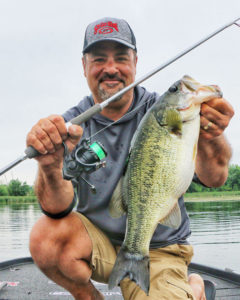
Park Falls, WI (June 4, 2019) – Cody Hahner, age 26, is one of the youngest St. Croix pro-staffers. An electrical worker from Wausau, Wisconsin with a penchant for muskies, Hahner is also an up-and-coming bass pro who broke onto the on the FLW Tour last year with a rousing rookie season. He cashed a few checks and qualified for the prestigious 2018 Forest Wood Cup.
Hahner came late to bass fishing, growing up – as many Midwesterners do – with a love of walleyes and a serious musky obsession. “It wasn’t until I learned that colleges had bass fishing clubs that I made the switch,” he recalls. “Once I realized I could fish and travel while still in school, I chose to attend the University of Wisconsin at Stevens Point, because they had a reputable team. Everything just snowballed from there.”
After graduating college and joining the FLW, Hahner got off to a fast start during his inaugural season. The sophomore jinx has him off to a slower beginning this year. Even so, Hahner remains determined to excel on the circuit.
“Nothing a little hard work can’t fix,” he says without hesitation. “I’ll probably head home at some point and fish for bass and musky on my home waters. Once I start figuring out those fish, I’ll be back fishing the trail with renewed confidence. I absolutely love the competition in bass fishing, but taking an occasional breather to simply focus on the fun of fishing is one trick I use to refresh and get back in the groove.”
That’s some wise thinking. Even at a relatively young age, Hahner is displaying some of the traits most successful veteran pros seem to have in common, including a passion for hard work and a willingness to adjust and try new approaches. He’s also really serious about choosing his fishing rods.
“These are your main tools,” he says pointedly, “so you need high quality, durability and sensitivity and a fair price,” he explains. “That’s one reason I like St. Croix Rods. They have the right tools for so many specific tasks, and yet many can also cross over from one technique to another. That gives me the flexibility and versatility to really stay in the game.”
Take largemouth bass, for example. Hahner points to a 7’ 4” medium-heavy moderate Mojo Bass Glass casting rod as his all-around favorite. “It’s a crankbait rod that can also be used for chatterbaits,” he notes. “It’s comfortable to hold, super accurate, has significant backbone and loads with a slight delay, which is perfect for lures that require the fish to really get a good hold before the hook is set.”
For bronzebacks, Hahner prefers a 7’ 6, medium-light, extra-fast Legend Elite series rod, noting it’s super-sensitive and perfect for throwing spy baits and hair jigs. “Even with the spy baits, which have tiny treble hooks, when I stick a fish on that rod it stays buttoned,” he says.
As for those muskies, Hahner is dialed in on two preferred choices. He likes a 9’ Premier extra-heavy rod for tossing large rubber baits like Lake X Tullibees and Lake X Toads. For working slow-moving big plastics and blade baits, however, his choice is an 8’6” extra-heavy fast Mojo Musky series rod.
For other millennial anglers hoping to join the pro fishing trail, St. Croix’s young pro-staffer offers three simple tips:
“First, don’t fret too much about the business end of things, that will mostly take care of itself as you get established. Second, be genuine to those you meet. Doing so will help you go a lot further in this sport than you otherwise might. Lastly, get on the water as much as you can to continue gaining experience and learning from your mistakes. That’s how the best pros get ahead and stay there.”
That’s sage advice from a budding professional who’s already wiser than his years.
#stcroixrods
About St. Croix Rod
Headquartered in Park Falls, Wisconsin, St. Croix has been proudly producing the “Best Rods on Earth” for over 70 years. Combining state-of-the-art manufacturing processes with skilled craftsmanship, St. Croix is the only major producer to still build rods entirely from design through manufacturing. The company remains family-owned and operates duplicate manufacturing facilities in Park Falls and Fresnillo, Mexico. With popular trademarked series such as Legend®, Legend Xtreme®, Avid®, Premier®, Tidemaster®, Imperial®, Triumph® and Mojo®, St. Croix is revered by all types of anglers from around the world.