Days like Sunday, April 11 make me wonder why I am addicted to bass fishing. Seven members of the Flint River Bass Club fished our April tournament at Lake Oconee. After eight hours of casting we brought four bass weighing about seven pounds to the scales. There were no limits and four us zeroed.
Jerry Regan won with two bass weighing 3.57 pounds, Don Gober had one at 2.01 pounds for second and big fish and Phil King’s one weighing 1.65 pounds was third. That was it.
It was a weird trip for me. AS week ago Sunday night after a shower I stepped out and the cool air hitting my body made me go into chills, shivering uncontrollably. I was miserable all night.
Last Tuesday, after two very bad nights with chills and body aches, I tested positive for both Covid and the flu! I had my second vaccine dose on March 24 but a second more accurate test Tuesday afternoon confirmed the Covid, even after the vaccine.
I did not feel terrible during the day but at night I hurt, to the point moving cover on my skin made me want to cry in pain. It felt like every muscle, joint and bone in my body ached.
Tuesday I took Tylenol every six hours and put some by the bed. That kept the pain down and I was able to sleep some, and felt better Wednesday morning and the fever was gone.
The doctor that gave me the test said I was the first they had to test positive after the vaccine, and warned me to quarantine myself for ten days. A few hours later I got a call from the state health department asking questions about where I had been and who I had contact with during the past two weeks. And they told me to quarantine myself until Wednesday this week.
I felt fine Thursday and Friday, night and day. I decided me alone in my truck going to the lake and in my boat alone on the lake was quarantine and fished the tournament. Plus, I was going stir crazy in the house!
To add to my woes, when I checked the boat Friday night, oil was dripping very slowly from my motor lower unit. Saturday morning, I tried to add oil to it. You have to remove two screws and pump the oil from the lower one to the top one. I pumped enough to see some oil come out the top hole and stopped.
Last summer I hit something and bent the prop shaft a little, just enough to let the oil leak out without my knowledge, and it cost me $4500.00 to fix it. Every time I cranked up Sunday I could hear the “clunk” in my mind of the motor locking up last year.
I idled around a little, never leaving sight of the ramp and never getting on plane, and fished close by. That is my excuse for not catching a fish, I could not go to where I won the Sportsman Club tournament at Oconee three weeks ago!
BRUNSWICK, Ga. (May 3, 2020) – Nesting season for loggerhead sea turtles has started on schedule.
The annual cycle of these massive turtles returning to beaches in the Southeast to lay their eggs began in Georgia with a nest found Saturday morning on Little Cumberland Island. Georgia Sea Turtle Cooperative members reported a second nest Sunday on Sea Island.
Georgia Sea Turtle Program Coordinator Mark Dodd said the first nests are “always around the first of May.” “It’s kind of like clockwork.”
This year’s first also has historical ties. While nesting has been monitored on all Georgia beaches since 1989, the network took root in 1964 when former University of Georgia professor Dr. Jim Richardson started the Little Cumberland Island Sea Turtle Project. That loggerhead monitoring effort is the oldest in North America and shares the status worldwide with a program started in South Africa the same year.
Little Cumberland Project Director Russell Regnery documented the nest on Little Cumberland Saturday. Hundreds more will follow on Georgia barrier islands, with nesting season for the state’s leading marine turtle and a protected species hitting full stride by June.
Predicting a total is anyone’s guess, according to Dodd, a senior wildlife biologist with the Georgia Department of Natural Resources. But one question is whether 2021 can top the 2,786 nests last year, or better yet, the 3,950 in 2019, the most since comprehensive monitoring began.
The state’s previous record was 3,289 nests in 2016. The total in 2019 also marked the first time the chunky-headed marine turtles had topped a Georgia recovery benchmark of 2,800 nests.
The loggerhead population has been increasing at approximately 4 percent annually since the early 1990s. However, a new population model developed by UGA and the U.S. Geological Survey using nesting and genetics data indicates the population will plateau at current levels for about the next 20 years, its progress hindered by low recruitment during the early 2000s, Dodd said. If current protections remain in place at least through that period, the model suggests loggerhead numbers would then start to increase again, possibly reaching levels not seen since the late 1950s.
Supporting that rebound is the goal of Georgia’s Sea Turtle Cooperative. The DNR-coordinated network of about 200 volunteers, researchers and agency employees patrols beaches daily during nesting season. Working under a federal permit, members mark, monitor and protect all loggerhead nests, plus those of other species that seldom nest in Georgia, such as green and Kemp’s ridley.
The effort not only eases predation and increases the number of young that hatch, the data collected is used to assess loggerhead populations, assess threats and inform management. Cooperators also help with beach management. The program has been in play on Georgia beaches for more than 30 years.
“The cooperative has done a tremendous amount of work,” and with a measurable impact, Dodd said. “We started out averaging about 800 nests a year and we’re now up to about 3,500.”
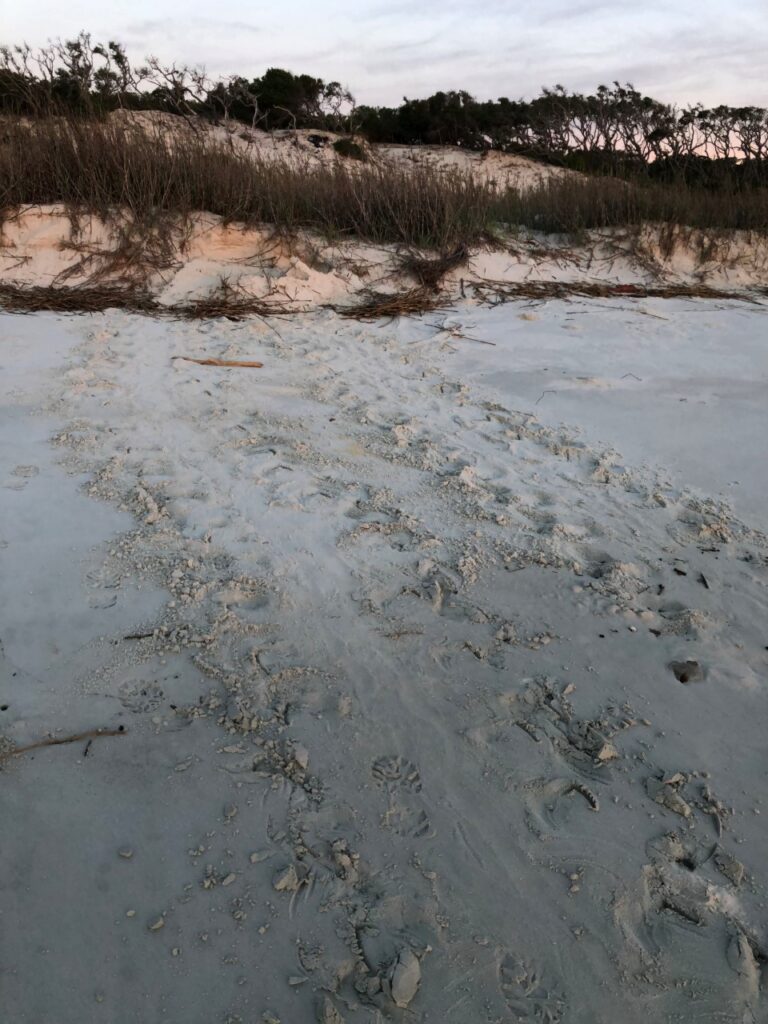
Like other marine turtles, loggerheads – named for their large heads – crawl ashore on barrier island beaches, dig a hole at the base of the dunes and lay their eggs, usually at night.
To prep for the season, Dodd and staff have been training interns, working with volunteers, partner agencies and organizations, and teaming with DNR’s Law Enforcement Division, all while navigating social distancing and other requirements involving the coronavirus pandemic. Game wardens enforce regulations including the use of turtle excluder devices, or TEDs, in commercial shrimping.
The process followed on Little Cumberland and Sea Island last weekend will be repeated hundreds of times this year. An egg from each nest – less than 1 percent of the average clutch size on the island – was collected for UGA genetic analysis documenting the number and relatedness of loggerheads nesting in Georgia. The nest was then covered with a screen to protect the eggs from predators.
DNR’s Wildlife Conservation Section works to conserve sea turtles and other wildlife not legally fished for or hunted, as well as rare plants and natural habitats. The agency does this largely through public support from fundraisers, grants and contributions.
Key fundraisers include sales of the monarch butterfly license plates and sales and renewals of bald eagle plate and older designs, such as the ruby-throated hummingbird. These tags cost only $25 more than a standard plate to buy or renew. Up to $20 of that fee goes to help wildlife.
WHAT YOU CAN DO
All marine turtles in Georgia are protected by state and federal law. To help conserve these species:
§ Minimize beachfront lighting during sea turtle nesting season. Turn off, shield or redirect lights.
§ When walking the beach at night, don’t use flashlights and flash photography. They can deter turtles from coming ashore to nest or cause them to abort nesting.
§ If you encounter a sea turtle on the beach, remain quiet, still and at a distance.
§ Leave turtle tracks undisturbed. Researchers use them to identify the species and mark nests for protection.
§ Properly dispose of your garbage. Turtles may mistake plastic bags, Styrofoam and trash floating in the water as food. After ingesting trash, it can kill them by clogging their intestines.
§ Protect beach vegetation: It stabilizes sand and the natural coastline.
§ When boating, stay alert and avoid turtles. Of the sea turtles found dead or hurt in Georgia last year, 26 percent suffered injuries consistent with being hit by a boat. Boaters who hit a sea turtle are urged to stand-by and immediately call DNR at 800-2-SAVE-ME (800-272-8363).
§ Also report any dead or injured sea turtles seen at 800-272-8363. (If the turtle is tagged, include the tag color and number in the report if possible.)
Sources: U.S. Fish and Wildlife Service, Georgia DNR
ACCIDENTAL CATCHES
Anglers who hook or entangle a sea turtle should call DNR at 800-2-SAVE-ME (800-272-8363). Also:
§ Keep your hands away from the turtle’s mouth and flippers.
§ Safely land the turtle using a net or by walking it to shore. Do not lift the turtle by the hook or by pulling on the line.
§ Leave the hook in place; removing it can cause more damage. (Anglers are encouraged to use non-stainless, barbless hooks when possible.)
§ Keep the turtle out of direct sunlight and cover it with a damp towel.
If an angler cannot reach DNR, cut the line as short as possible and release the turtle.
LOGGERHEADS AT A GLANCE
§ Caretta caretta: Most common sea turtle on Georgia’s coast; found off coast year-round. Also one of the world’s largest turtles, topping 350 pounds and sporting a carapace up to 44 inches long. How long loggerheads live is not known.
§ Range: The Atlantic, Pacific and Indian oceans, and the Mediterranean Sea. Nests in the U.S. from Virginia to Texas.
§ Nesting: Females reach sexual maturity at 30-35 years. From about May through September, they crawl ashore at night, dig a hole in the face of dunes along barrier island beaches, and deposit and cover eggs.
§ Pilgrimage: Eggs hatch in 55-65 days. The young scramble for the water, beginning a journey that can take them from sargassum weed off Georgia’s shores to a current-powered loop that circles to the Azores and the eastern Atlantic Ocean, south to west Africa and back to the western Atlantic.
§ Eats: Fish eggs and small invertebrates when small. As adults, they eat mainly crabs and mollusks, but also forage items like jellyfish and dead fish.
§ Status: Federally listed as threatened since 1978. Georgia DNR reclassified loggerheads in the state from threatened to endangered in 2006.
§ Threats: Primarily mortality associated with commercial fishing activities, but also nest predation by raccoons and feral hogs, poaching, loss of habitat, boat strikes, and even ingestion of plastic litter mistaken as food.
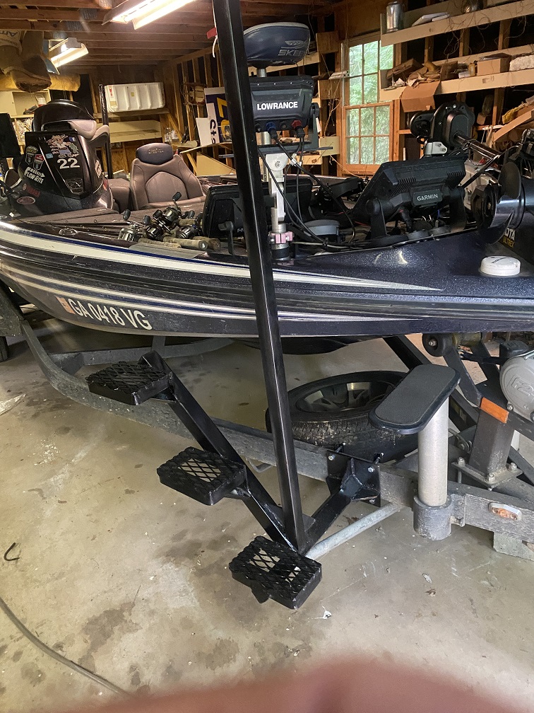
James installed these on my boat last Sunday after our West Point tournment for $250! You can get some from him at 706-668-3459 cell or 770-854-8713 home.
Last Sunday 27 members of the Potato Creek Bass Club fished our April tournament at Lake Lanier. We landed 84 14-inch keeper bass weighing about 174 pounds. There were nine five-fish limits, and one person did not weigh in a bass.
Jamie Beasley won with five weighing 13.16 pounds, Sam Smith was second with five weighing 12.93 pounds, third went to Jeff Wright with five weighing 12.75 pounds and Edward Folker was fourth with five weighing 12.57 pounds. David Martin had a largemouth weighing 4.74 pounds for big fish. Most of the fish weighed in were spotted bass.
I went up on Tuesday and camped at Don Carter State Park. Don Carter is our newest state park and it had very nice facilities. The campground is spacious and there are great bath houses but there are also hiking trails, horse riding trails, a beach and cabins.
I put in at the park way up the river on Wednesday and fished the stained water in small coves. The water was stained and in the low 60, a perfect combination for the way I like to fish this time of year, but after five hours I landed four keeper bass.
I did catch two nice largemouth on a buzzbait, one about 2.5 pounds and one close to four pounds, but both hit later in the afternoon. I did not think it was worth the 20 mile boat ride up there from our tournament launch site.
Several folks told me there was a good bite on the lower lake fishing Flukes around boat docks, so Thursday I put in at Balus Creek, our tournament launch site, and tried that pattern for several hours without a bite. The back end of Balus Creek was stained and there were shad everywhere but I could not get a bite there, either.
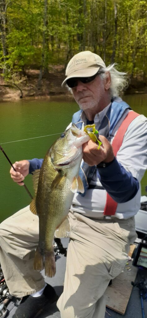
I did finally catch a four-pound largemouth from a dock in the back of a creek, on a Carolina rig of all things, but that was no pattern. One bite does not tell me much, even though it was a good one.
On Friday I tried different things and final caught one keeper spot from a brush pile on a Fluke. I had no idea what to do in the tournament, so I decided to fish memories.
The first rocky point I want to fish Saturday morning had a boat fishing it so I tried other things. At 11:00 I had not caught a fish so I went back to the first point and caught two keepers and two short fish and lost another keeper, all in 20 minutes.
By 2:00 I had not had another bite, including fishing all the docks where the big hit on Thursday. I stopped on another rocky point on the way in to the ramp and caught two more keepers the last hour. All four hit a Carolina rig but four weighing five pound was good for about 20th place!
By Joel Nelson, Northland Fishing Tackle from The Fishing Wire
Walleye-anglers are a traditional bunch in-general. New techniques and technologies are directly compared to known commodities, and rightly so. There’s no use making things more difficult than they need to be, yet sometimes along the way what’s learned is in and of itself valuable. I find that to be especially true in the case of side-imaging electronics for walleye fishing.
So often, structural anglers are used to locating a spot of interest via high definition contours, then picking those locations apart with traditional down-sonar in an effort to locate fish, catch them, and store location (GPS) information in order to return to that spot someday down the road. Lest we forget, at one time this technology was also new, though its adoption was rapid among the ranks of professionals and casual anglers alike. Still, I’ve heard it mentioned in even upper echelons of walleye nerdery that side-imaging is only for “bass-guys.”
A staple among tournament bass anglers these days is side-imaging runs that map both structural elements, and individual fish to target. At last year’s Bassmaster Angler-of-the-Year tournament on Mille Lacs, dozens of complete strangers to the fishery pulled 60lb. bags of smallmouth bass during the 3-day competition, most of them leaning heavily on using their side-imaging to locate large boulders and individual bass off them. This very application, while being a classic use of the technology, is not a reason to classify it as a “bass-only” benefit.
Shallow water walleyes can be found throughout the warm-water months during big wind events, even in clear water. That same clarity provides a solid reason to consider side-imaging on your next electronics purchase, as walleyes rarely tolerate overhead boat traffic in clear-water shallows. The imaging becomes your eyes up shallow, allowing you to stay back off of the fish, and put a multitude of presentations to them without pushing them around and killing the bite. Shallow fish are typically feeding, so these are the fish you’re looking to target anyway.
While side-imaging proves very valuable for any species relating to shallow structural elements, the same also holds over the depths. It’s a common misconception that side-imaging isn’t useful at the same depths we’re typically targeting walleyes. On a recent trip to Grand Rapids, MN, I used my Lowrance Carbon-12 to image an underwater point I’ve fished often, both during open-water and through the ice. While I knew there was an 8-foot rock-pile along the shallow lip of it, I didn’t give credit to that rockpile and how it affected walleye movements out and away from it. All of our bites came off the pile some distance in 14-18FOW, as fish staged there before dark awaiting the low-light evening assault on those shallow rocks. Not surprisingly, immediately out from the pile was a hard-bottom, rock-free shelf. It was noticeably different from the surrounding break, and drew the majority of those fish. Once I knew what I was looking for, I could find it on the down-sonar, but it literally jumped out at me on the side-imaging.
An even deeper application can be found on the famed mud flats of Mille Lacs, where savy anglers for many years have known that not all parts of all flats are mud. There is a surprising amount of rock and gravel in certain locations, though most are in small out of the way places along the edge of the flats. With a good chop, and the resultant screen display of your sonar showing a “wavy” bottom, it’s difficult to detect the tell-tale signs of rough or un-even rock bottom. These locations, being different from surrounding substrate for at times, miles, almost always have fish on them or nearby.
Perhaps the best way to introduce yourself to the technology is to image an area you already know, preferably if you know it holds fish. So often as walleye anglers we stumble onto a mere piece of the puzzle. We catch fish on one side of a reef for a short period of time in late afternoon, without realizing that we only intercepted fish in a 30 minute window making their way out of the depths and up to structure to feed. Even if we know fish are likely to be up top and actively eating, we know not what locations have the largest boulders, the most pronounced feeding shelves, or what areas are too weed-choked to effectively fish in low-light. All of those answers can be gleaned from a quick pass or two around the structure of interest.
Take this technology for a spin on a few locations you’ve fished for years, and be amazed at the depth and level of information it offers you. Consider it the best real-time map that’s offered today, and get used to seeing and interpreting what information in the plan direction really means to your fishing, rather than just the profile depth direction we’re so used to seeing in the sonar of old.
ID used to identify users for 24 hours after last activity
24 hours
_gat
Used to monitor number of Google Analytics server requests when using Google Tag Manager
1 minute
__utma
ID used to identify users and sessions
2 years after last activity
__utmt
Used to monitor number of Google Analytics server requests
10 minutes
__utmb
Used to distinguish new sessions and visits. This cookie is set when the GA.js javascript library is loaded and there is no existing __utmb cookie. The cookie is updated every time data is sent to the Google Analytics server.
30 minutes after last activity
__utmc
Used only with old Urchin versions of Google Analytics and not with GA.js. Was used to distinguish between new sessions and visits at the end of a session.
End of session (browser)
__utmz
Contains information about the traffic source or campaign that directed user to the website. The cookie is set when the GA.js javascript is loaded and updated when data is sent to the Google Anaytics server
6 months after last activity
__utmv
Contains custom information set by the web developer via the _setCustomVar method in Google Analytics. This cookie is updated every time new data is sent to the Google Analytics server.
2 years after last activity
__utmx
Used to determine whether a user is included in an A / B or Multivariate test.
18 months
_ga
ID used to identify users
2 years
_gali
Used by Google Analytics to determine which links on a page are being clicked
30 seconds
_ga_
ID used to identify users
2 years
_gac_
Contains information related to marketing campaigns of the user. These are shared with Google AdWords / Google Ads when the Google Ads and Google Analytics accounts are linked together.