| Early-Season Musky Methods |
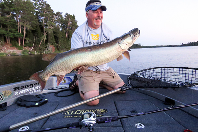
| St. Croix pros discuss favored tactics and gear for early-season muskellunge (press release} Park Falls, WI (May 20, 2020) It’s just about time. Musky aficionados are fastidiously prepping gear and anxiously awaiting season openers across the big fish belt. They know that late spring and early summer can be some of the most exciting and productive times to be on the water, as big, banded brawlers – fresh off the spawn and unpressured by anglers for months – are becoming increasingly active with warming water temperatures. Such is the case in all the great musky waters – from Indiana, Kentucky, West Virginia and Iowa through Michigan, Wisconsin, Minnesota and the Canadian provinces – although different fisheries are heating up and opening to anglers at slightly different times. What can you do to be fully prepared for this magical time of year? Start by reading what professional musky guides and St. Croix pro-staffers Rob Manthei and Steve Herbeck have to say, as well as St. Croix’s own musky expert and rod-designing maven, Gavin Falk. |
| Wisconsin Guide and Big-Fish Expert, Rob Manthei Here in Northern Wisconsin our season doesn’t open until the end of May. Judging by what I’ve seen with ice-out, we should have a typical opener. As soon as the season opens, I’ll be fishing a lot of wooded shorelines and looking for any kind of new, green weeds. I’m generally concentrating on a couple styles of baits – twitching small minnow baits and throwing small bucktails. As far as rods, I’m a fan of the 8’ one-piece, medium-heavy power, fast action St. Croix Mojo Musky casting rod (MJM80MHF). That’s a great rod for throwing these smaller baits, and the newly redesigned Mojos are just great rods. The Winn Grip is awesome—it allows a confident feel when you’re hanging onto it wet, dry, or anywhere in between. It’s very comfortable and the looks of the rod are spectacular. The Kigan Master Hand 3D guides and top St. Croix uses on this series are large, which are great for anglers like me who want to tie a longer leader with a surgeon’s knot or uni knot. Those knots go through the guides just fine; they’re very durable that way. |
| Another new Mojo Musky model to look at is the 6’10”, medium power, fast action rod (MJM610MF) – especially if you’ve got a son, daughter or any other young person in the boat who’s been bitten by the musky bug. This shorter, medium power rod is one that kids can pick up, cast easily with a variety of effective lures, and experience success with. Overall, the physical weight of the new Mojo Musky rods is exceptional; not at all overbearing. And they’re one of the best values of musky rods out there. With 14 technique-specific models and the quality you get for their price, I don’t think Mojo Musky can be beat. Some other St. Croix rods to look at for the early season are the three Legend Tournament Musky Downsizer models. You want to talk about precision casting capability with the smaller baits that work so well before the water warms up, and being able to do it all day long without fatigue? That’s what these rods were made for. I know… medium-light power in a musky rod? The key to making it work is that their relatively long 8’6” and 9’ lengths, ultra-responsive SCIV carbon blanks and fast actions all work together to provide immediate access to that power. It’s amazing. All I can say is that anglers need to fish them to fully appreciate what St. Croix has accomplished with these three, highly capable, specialized rods. |
| As we start transitioning out of spring, early-summer patterns depend on the kind of water and forage. We have dark-water flowage systems and big, deep natural lakes that are cisco-based. A lot of times, the month of June is a great time for open-water fishing. You can catch fish trolling, but catching them casting is always more fun; it’s definitely a time of year where you can be effective just casting open water with plastics. Humps, saddles and other anomalies on and around expansive shallow flats are good places to key in on, as are concentrations of suspended forage. Obviously, when you’re casting and working a lure you can put in a lot more action into it that you can’t duplicate while trolling. This is when I’m throwing Musky Innovations Swimmin’ Dawgs and other tight paddletail baits from Chaos Tackle or just flat out rubber, whether that’s Medusas or Bull Dawgs. Now when you’re throwing these big rubber baits you’re going to need a bigger rod and this is one area of casting where I typically tell people don’t worry about the length of your cast; just bomb it out there and cover water. This is definitely where you want to start grabbing that heavier Mojo Musky rod in the 8’6” to 9’ range. The telescopic one-piece rods like the 8’6” telescopic, heavy power, fast action (MJM86HFT) and 9’ telescopic, heavy power, fast action (MJM90HFT) work great. Those are the rods I’m throwing a lot of these bigger, heavy rubber baits with. And for anglers who don’t have a giant rod locker, they can finally start carrying 9 foot musky rods. The 8’6” model collapses to a manageable 7’6” and the 9’ models down to 7’10”. That’s a really slick advantage when it comes to transportation and storage. |
| Legendary Musky Guide and St. Croix Pro, Steve Herbeck: Musky guide and St. Croix pro, Steve Herbeck, has expertise throughout the storied, northern musky regions of Wisconsin, Minnesota, and Michigan, and has also been a resident guide and teacher at Andy Myer’s Lodge on Eagle Lake in Ontario for 28 years. As director of the world-renown lodge’s guest fishing instructor program, Herbeck has an intimate understanding of the acclaimed musky fishery that has produced world-record fish and is considered by many to be the top, big-musky fishery in Canada. Very typically, around the opener in Northern Wisconsin you’re going to have water temperatures and fish that are just finishing up the spawn. Occasionally, with a late spring you’ll hit them during the spawn, but usually they’re done when the water temperature is between 56 and 60 degrees. When that’s the case, they’ve just gone through a major stress and we’re going to start with smaller baits. That’s one reason why so many big muskies are caught accidentally by walleye, bass, and pike fishermen during this part of the season. At this time of year, muskies really do really prefer smaller baits for their consistent action. We’re talking six-to-seven-inch minnowbaits, #5 to #8 size blades, smaller topwaters, smaller jerkbaits, and medium-sized rubber baits, so, consequently, we’re going to match our rods for best efficiency to the size of the baits we’re throwing. I just love the 8’6” one-piece, medium-heavy, fast action Mojo Musky rod (MJM86MHF) for this application. I pair it with 65-pound braid loaded on a mid-range 500-series reel. I also match the baits with lighter leaders for the best action. Mojo Musky rods and Legend Tournament Musky rods in these lengths and actions are just superb for these smaller and lighter bait applications. You can cast them a mile, they have just enough tip that you can really work a smaller bait and use lighter lines so you have good action, and yet they have enough butt that you can make great figure-8s and really set the hook. Rather than overpowering a small bait with a 9-foot heavy or extra heavy rod, this is what I prefer to use and put in my clients’ hands. Don’t overlook bigger baits in the early season, though. If I’m really looking for big fish only – you’ve got to remember they’ll be grabbing 12-to-20-inch walleyes as forage – I still use some bigger baits, especially baits with reaction to them that simulate injured fish like medium and regular-sized rubber baits, Suick-type jerkbaits, and zig-zag baits. Jerkbaits can be very productive in these colder water conditions if you’re looking for bigger fish. And for those types of baits I really like a 7’6”-to-8’ rod a little bit more on the heavy side. The Mojo Musky, Legend Tournament Musky, and Premier Musky families all offer superb models in that category. I’ll go to 80-pound line and standard size reels. That’s kind of the early-season trend in Northern and mid-Wisconsin and Minnesota. |
| When we get into the Canadian version of this time period – we’re talking the third weekend of June – most of the musky range is from the border to about 150 miles north, and then the musky habitat disappears so it’s not that much colder than northern Minnesota, Wisconsin and Michigan. The reason the Canadian opener is held later is the fisheries are all natural and none of it is supplemented by stocking. They want to make sure that all fish have completely finished spawning. That being said, we’re typically in the 60-to-mid-60-degree-water-temperature range and well past the actual spawning time. Because many of these Canadian lakes are very, very big and warm slower – like Lake of the Woods, Eagle Lake where I’m at, Rainy, and Lac Seul – some of these lakes are virtual oceans, so to speak, so they warm up slower, but are usually in that 60-degree range and we’re typically a week past spawning. In warmer years or in smaller waters, we may already be in that early-summer pattern with fully recuperated fish. We still start with smaller-size baits but quickly graduate to larger baits, mixing them up to let the fish decide what they want. So we’re using a combination of actions and sizes of rods. Someone in the boat might be throwing an 8’6”-to-9’ heavy like the Legend Tournament Musky Sling Blade – that’s an awesome rod – or now the 8’6”-to-9’ telescopic Mojo Musky rods. The telescopic Mojo Musky rods are fantastic choices for this combination approach. That’s what makes the St. Croix lines of rods so awesome; they’re application-specific so you can literally fine-tune your presentations as well as reduce your fatigue level by using the proper rod. |
| St. Croix makes the finest and widest selection of musky rods available across multiple price points. Their Legend Tournament Musky and Legend Elite Musky rods are the absolute pinnacle of performance, but for the money, it’s hard to beat the newly redesigned Mojo Musky rods. Aesthetically, it’s a beautiful rod that looks fantastic with most reels. Its SCIII and IPC composition makes it very durable for the weight of the rod. I’ve tested various models extensively, and I’m impressed with Mojo Musky’s durability. For many years, Andy Myer’s Lodge has used the Mojo Series for muskies, walleye, and bass as our guest rods. These rods see above-average abuse, and the Mojo models stand up to that abuse extremely well. The new telescopic rods have been a great addition for us, too, because not all boat rod lockers are designed to hold 9 foot rods. That makes them very easy to store and keep out of harm’s way when they’re not being used. The other key thing is that with 14 distinct models, the Mojo Musky line offers a host of options in terms of covering any angling situation we might encounter… and at a fantastic price point. It’s a very angler-friendly series. |
| Gavin Falk, St. Croix Rod Engineering Supervisor and Musky Fanatic:St. Croix Rod Engineering Supervisor, Gavin Falk, is a passionate musky angler with a great deal of experience with the new Mojo Musky series, both on and off the water. For early-season situations, Falk fishes a lot of jerkbaits with the 7’6” one-piece, extra-heavy power, fast action (MJM76XHF) model, as well as the 8’ one-piece, heavy power, fast action (MJM80HF). And for smaller rubber baits he recommends the 8’6”, heavy power, fast action (MJM86HFT) or the 9’, medium-heavy, fast (MJM90MHFT) telescopic models. For smaller minnow baits and bucktails – both solid offerings for early season – Falk recommends the 8’6” one-piece, medium-heavy power, fast action (MJM86MHF) Mojo Musky. Delving more into the specifics of the new Mojo Musky rods, Falk cites numerous characteristics as improvements that anglers should be aware of. “First off, with IPC® mandrel technology the actions are greatly improved,” he says. Fast actions were good in the previous generation of Mojo Musky, but now they are truly fast, so it’s a lot easier to keep tension on fish because you’ve got that deflection in the tip, which also helps with casting, too. That’s a big thing. IPC also helped us reduce the overall weight of the rods while maintaining strength and durability.” |
| Falk talks about the move from cork to custom Winn split grips, as well as improvements to the reel seats: “The new grips are phenomenal. Using heavier braid throws off a lot of water into your hands and you can fish all day with the new Winn grips, even if your hands are wet or slimy. We also increased the diameter of the grip sizes, so, ergonomically, they’re more comfortable in the hands. Finally, we put a deluxe nut in the reel seat, so tightening down reels is a lot easier compared to the standard nut that was on previous models. Right now is the time to start prepping for big-fish hunting. Consider the tips from our pros in the know, and you’ll be starting this year’s musky season in a positive direction. And if you’re looking to add to your collection of musky rods, timing couldn’t be better. Now until May 31, anglers can enjoy FREE SHIPPING when they shop and purchase any St. Croix Mojo Musky rods at stcroixrods.com. Don’t wait! This offer is limited to available stock at the time of purchase and is only applicable to orders shipping within the continental United States. |
| #CROIXGEAR Like the rods? You’ll love our lifestyle apparel. Shop now! |