GPS Coordinates for Catching Lake Jackson Bass

March Bass at Jackson Lake 

with Barry Stokes

     For many years Jackson Lake was known for its big bass.  Then spots got into the lake and it seemed the big lunker largemouth got very rare, but you could catch a pile of keeper size spots.  Stringers with several six to eight pound bass are not seen like they were years ago, but 20 pound tournament catches still happen.

     Filled in 1911, Jackson is the oldest big reservoir in the state.  This Georgia Power lake on the headwaters of the Ocmulgee River covers 4750 acres and its shoreline is lined with cabins, docks, rocks and wood cover.  Most of its channels are silted in but there are plenty of sandy spawning coves on the lake.

     Barry Stokes grew up near Jackson and fished farm ponds but did not get to fish Jackson much. He watched bass boats go by his house headed to the lake and was determined someday to be in a bass boat on Jackson like those guys.  He made those wishes come true in the early 1990s and joined the Conyers Bass Pros bass club. Later he joined Bear Creek Bass Club.

     In the past 15 years Barry has learned the lake well and, starting in 2001, fished as many pot tournaments on it as he could. He fished the old R&R, Dixie Bass and Charlie’s Bait and Tackle trail as well as the night and weekend pot tournaments on Jackson. Now he fishes the Berry’s trail, ABA, and any other tournaments on the Jackson.  He also fishes the BFL, HD Marine and other tournaments on Sinclair and Oconee. He is usually waiting around on a check after weigh-in in them. 

     Barry has learned the lake so well he now guides on Jackson as well as Sinclair and Oconee.  He knows how to pattern the bass on the lake and has learned how to catch them. His best day ever on Jackson he landed a 12 pound lunker and had five fish weighing 30 pounds.  In one string of tournaments he won 11 of 13 tournaments and had big fish in all 13.

     Over the years Barry has figured out good patterns for March bass.  In late February they start staging on rock, clay and sand points near spawning coves and feed up on crawfish and baitfish.  He can usually catch them four to eight feet deep on those points. 

     As the water warms during March Barry follows the bass from the points back into the spawning pockets. Some bass will bed in early March if the water temperatures go up and stay stable for a week and bass move into the bedding areas in waves all spring.  There will often be a lot of pre-spawn fish on the points, some moving back and even some on the beds this month.

     “Details are the key,” Barry told me.  He keeps a variety of baits tied on and also has others ready to try. He will vary the details like lure color, depth and speed he retrieves them all during the day until he finds the key. If the fish quit hitting he will start varying the details again until he unlocks the new pattern.                    Barry will have several kinds of crankbaits in different colors, a Ol Nelle spinnerbait, a Net Boy Jackson Jig and pig, a Net Boy Shaky Head, a Terry Bowden’s Cold Steel lizard worm and a Cold Steel Walking Stick all rigged and ready when he heads out this month.  The colors will vary with water color, with brighter colors for stained water and more natural colors for clearer water.  But he will vary all the details during the day.

     One of the details Barry pays attention to that many bass fishermen get lax on is speed he works the baits.   He will vary his speed until he hits what is working. Too many bass fishermen have a speed of retrieve they are comfortable with when using certain baits and don’t very it. Barry constantly changes. 

As the water warms the fish will get more active this month and chase a bait better, but some cold days they want a fast moving bait, too.  As a general rule you should fish slower in cold water and faster in warmer water, but Barry says pay attention to details and vary your speed constantly.

Barry and I fished the following ten spots in mid-February and bass were already on them.  We caught 20 to 25 bass that day and Barry caught almost all of them on crankbaits, but I managed a few of the bigger fish on a jig and pig.  These spots will pay off all month long as fish move up on them then move back to spawn.

1. N 33 25.195 – W 83 49.875 – Run up the Alcovy to the cove on the left called “Parker Neck” and look at the upstream point.  There is a small concrete piling/pier on the up stream side right on the edge of the water and a blowdown runs out off the end of the point.   The house on the point is brick half way up with green wood above it.

This point is an excellent staging area. The bottom is rocky and the pocket on the downstream side, Parker Neck, is a good spawning place.  Fish hold out on the point on the rocks and in the blowdown feeding then move into the cove to spawn as the water warms.

Barry starts out on the end of the point at the blowdown and fishes the tree and the rocks with a crankbait, spinnerbait and jig.  He will then work the bank going downstream all the way past the cut to the next point with a gazebo on it.  Fish the above baits but also try a shaky head worm, and a Texas or Carolina rigged Lizard Worm along this bank. Work the sand where the bass will be bedding.

2. N 33 24.301 – W 83 49.746 – Headed downstream Price Neck is on your right and a good rocky point is on your left. The point you want to fish has a small cabin on it with lattice work around the crawl space.  There is a white painted tire laying in the yard. Back in the pocket on the downstream side there is a house that runs right to the water’s edge.

This point runs out shallow toward the downstream side and there is some brush on the downstream side.  The bass spawn in the cut on the downstream side.  Stay way out and fish a crankbait, spinnerbait and jig around the rocks and brush, then work into the pocket with the other baits. Try to vary your colors and speed until you find what the bass want.

One trick Barry uses is to Texas rig a Cold Steel Walking Stick, a Senko like bait, and fishes it around all the cover in the pockets. It skips under docks well and has a little different action and look than the jig and pig that most anglers will be throwing. This is another example of the types of details Barry uses to catch bass behind other fishermen.

3. N 33 23.035 – W 83 50.279 – Downstream of the bridge and Berry’s there is a point on your left heading downstream that has a beige house with a brown roof on it. There is a three globe light pole in the yard and a dock on the point with a deck on the bank. The deck has lattice panels around it. There are big rocks on the point and the bass spawn in the pocket on the upstream side.

Barry says this is a numbers game point. Spots stage and spawn here and you can often pick up several fish.  Crank the point then try a spinnerbait. Start on the downstream side and parallel the point fishing from near the bank casting out toward the lake. Then work out around the point fan casting both baits.  It gets real shallow on top so don’t get in too close.

After working the point work into the spawning area dragging a worm on the bottom. Barry likes a green pumpkin Lizard Worm this time of year and dips the tail in JJs Magic chartreuse dye to give it some color. Spots seem to especially like the wiggling chartreuse tails.

4. N 33 22.225 – W 83 51.113 – Go under the power lines and you will see a swimming beach and picnic area for Turtle Cove on your left. There are three buoys in front of the beach and the point that runs out downstream of it is a good staging area. The point is red clay and rock, an excellent combination for holding bass this time of year.  They are often feeding on crayfish on this kind of point.

The point runs at an angle downstream across the mouth of a cove.  Start near the swimming area where the sand transitions to clay and rock. That kind of change often holds bass. Work it then keep your boat way our and go downstream, fan casting around the point. 

There is a real good drop on the inside of this point where the small creek coming out of the pocket runs by it. Fish that drop and the blowdown on the inside of the point.  Flip a jig in it and work a spinnerbait through it.  Then work on into the creek for spawning bass.  This is an excellent spawning area and holds a lot of bass.

5. N 33 22.044 – W 83 51.376 – Go past the next cove downstream and you will head straight in to a high bluff bank.  The old river channel swings in right by it and it drops off fast. There are three small points along this bluff bank you should fish in March.  Start on the outside one at the dock on the rock sea wall in front of the series of decks running up the hill to the house. 

It is rocky and holds the first transitioning fish coming up out of the river channel. Stay out and fan cast it then work toward the next dock. There is a rock ledge that runs out under the dock. You will see the dock with a walkway that runs behind a tree leaning out.  The dock has the numbers “3108” on the walkway.

Stay out from the dock on the downstream side and cast toward the walkway and tree. You can see how the rocks run parallel to the bank coming out. Run a crankbait, spinnerbait and jig along these rocks, then work around the dock and fish the other side. Also drag a plastic bait along the bottom here.

The next point going into the creek is a round clay point and you should fish all around it, then fish into the creek, concentrating on any sand you come to.  The Lizard Worm is a good choice on sandy spots since spawning fish will hit it.  You may not see the bed but can catch fish off the beds with this bait.

6. N 33 22.202 – W 83 51.771 – Round the point headed into the South River and you will see a sharp narrow point on your right.  It comes out and drops off fast on both sides but is shallow on top. There is no house on the point but you will see four benches on it and there is a concrete boat ramp on it.  There are two pines on the point with black protectors around their bases.

The point is rock and clay and bass spawn in pockets on both side of it. It is steep and gives bass quick access to shallow water. They can hold deep and quickly move shallow without moving far.

Start on the downstream side and work around the point, staying way out. Fish along the upstream bank leading into the next pocket up. Rocks, clay and sand along this bank hold bass and they will move along it feeding and working into the spawning pocket. Barry will usually stop fishing about where the seawall starts unless he is going back into the pocket for spawning bass.

7. N 33 22.294 – W 83 61.856 – The next point up also has good deep water access.  This point has a brown cabin and there was a US flag flying on the dock in front of it when we were there.  There are two floodlights on a tree right at the dock. There is a big blowdown on the upstream side and a rockpile out on the point.

The wind can be important here and on other spots this time of year. Some wind blowing across the point or into it helps and Barry will fish wind-blown points as long as he can hold his boat on them.  Wind creates current that moves the food baitfish eat and they will follow it. Bass wait on the baitfish.

Start at the blowdown and fish it. Then get out about even with the flag pole and cast across the point, aiming your casts parallel to the bank toward the cove.  You will hit some rocks on this point and that is where a school of bass will often hold.

The downstream pocket is full of wood and a good spawning area. Especially near the end of the month Barry will fish into it, running his Ol Nelle spinnerbait along the wood. He likes a double Colorado blade bait with white skirt, especially in clearer water, but will go with double willow leaf and chartreuse and white skirt in stained water.  He will also flip a jig around the wood before leaving.

8. N 33 21.446 – W 83 51.763 – Head back down the river and it will narrow down. Straight ahead you to the right you will see a pink house with tin roof on a flat point that runs out upstream of a bluff point. There is a green picnic table in the front yard.

Get on the downstream side of the point and cast in toward the seawall. The bottom is very rough here and often holds a lot of bass. Fish this bank into the pocket, working the dock and fishing to the boat ramp. Be sure to his this boat ramp and any others you come to before leaving.

9. N 33 21.393 – W 83 51.391 – The lake opens up just at this point and the far left bank going downstream has a creek coming out. In the mouth of this creek is a hump that is marked with three danger buoys.  It is deep on both sides and bass stage on this hump before going in to spawn.

Barry likes to stay out on the lake side and cast up onto the hump, bringing his baits back shallow to deep. Wind often blows in here and makes it better.   There are rocks and clay on this hump and you should fish all the way around it before leaving. Try all your baits in different colors and speeds. Assume the bass are here and you just have to figure out the details to get them to hit.

10. N 33 22.047 – W 83 53.882 – For something a little different run up Tussahaw Creek under the bride on up to the last pocket on the right before the weekend “no wake” section. You will see a green metal roof dock in front of a brown house. There is a little narrow point here downstream of two small pockets. The point has a cross tie seawall and a big Pampas Grass clump on it. Downstream of the point you will see a white cabin with a red roof just past a blue cabin.

There are some stumps on this clay point and the bass will stage on it.  Fan cast all around this point and try all your baits here. The water is often clearer in the Tussahaw so you may need to change colors to draw strikes. 

These are some of the places Barry will be fishing this month. They will pay off for you, too.  Barry has caught a lot of bass off all of them and gives credit to Jesus Christ, his lord and savior, for his successes.

Call Barry at 770-715-2665 for a guided trip on Jackson, Sinclair and Oconee or visit his web site at www.barrystokesfishn.com.   You can see Cold Steel products at www.teamcoldsteel.com/, JJ’s Magic at www.jjsmagic.com/ and Net Boy Jackson Jigs at www.netboybaits.com/.

Crappies on the Ice

Ice Crappie

LIVETARGET Tips for Run-and-Gun Crappies on the Ice
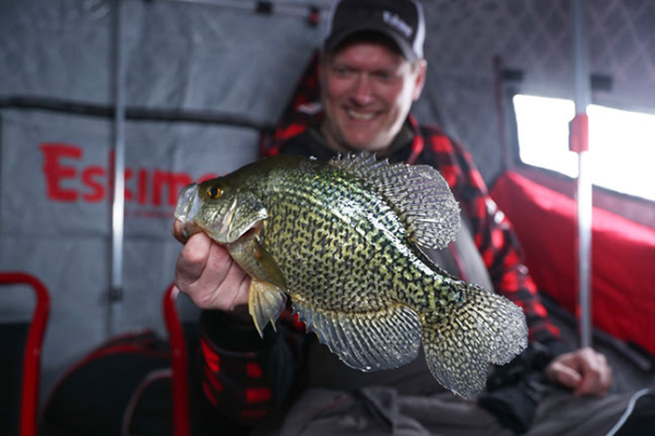
 Niagara-on-the-Lake, ON  – Of the various species pursued by ice anglers, crappies may be tops. They’re a blast to catch and provide great eating. And while there are a bunch of ways to catch crappies – everything from tungsten jigs to spoons to set-lines with live bait – more and more anglers are discovering that the crankbait game isn’t limited to open water when it comes to catching more and bigger slabs. Progressive ice anglers are fishing rattlebaits alone and in tandem with other systems, and they’re turning out big fish all across the ice belt. Although rattlebaits will work the entire season, right now – early-to-mid-ice – is the perfect time to capitalize on these presentations.

Location and Timing For North Dakota-based LIVETARGET ice pros Scott Brewer and Kyle Agre of Brewer-Agre Outdoors, the first part of the crappie equation is locating fish. And when it comes to crappies, early- and mid-ice season fish will remain close to the same depths and locations they were found during late fall.

“For me, it’s finding that deep basin, preferably adjacent to a weedy flat or a weedy bay,” says Agre. “That’s where they’re going to be after they move out of the weeds.”Brewer agrees that weeds are key. “And the edges of green weeds on the drop-offs,” he adds. “Ideally, you’ll find a drop-off with green weeds close to that deep-water basin. The crappies will hang out there for quite a while. Crappies are also headed toward holes. If you can find a hole on a flat somewhere – a 10- or 15- foot flat that’s got a 20- or 25-foot hole – those crappies are going to be there already during early ice and remain there a good portion of the winter.”

Agre says the adjacent basins really come into play once the weeds die. “Finding the right locations really comes down to knowing that these fish were relating to the weeds until the food moved on,” he says. “The weeds will die off to a point where they’re not sustaining the plankton, the minnows, baitfish, and everything else. At that point the crappies are going to slide out into the deeper water and they’re going to feed on the whole food chain that’s taking place out there with plankton, insect larvae, baitfish and so on.

”Once prime areas are located, it comes down to drilling a lot of holes and jumping from spot to spot to find active crappies. Electronics increase efficiency. Rather than hunkering down in one spot and waiting for prime times, this kind of fishing can produce fish when the majority of anglers would either stay on shore or simply wait out the hours until set-line bobber and minnow combinations start producing.Also, there are a lot of anglers who can only fish when they have time, which might be during the day or outside of those prime-time hours. Run and gun crappie fishing is the perfect solution.

The One-Two Punch Scott Brewer says that’s when loud baits like the LIVETARGET Golden Shiner and Perch rattlebaits really come in handy, because they allow you to search for fish fast. As an added benefit, these baits are magnets for the largest, most aggressive crappies in the school, so they can often act as a filter for better-quality fish.

“The smallest of the LIVETARGET Golden Shiner and Yellow Perch rattlebaits work great for searching out and catching large crappies,” says Brewer. “Even during the middle of the day, hole-hopping with a rattlebait can pay out dividends that you just don’t get when hunkered down with a set-line or smaller tungsten set up.

”For Brewer and Agre, they almost always utilize a one-two punch of a LIVETARGET Golden Shiner Rattlebait or Yellow Perch Rattlebait on one rod, and the smallest LIVETARGET Erratic Shiner spoon (1/4-oz.) with a minnow head on a second throwback rod. “I think that whether the angler is going to fish aggressively or sit tight and be a little more subtle, having that lipless crank on can play to both techniques.

When running and gunning you’re looking for those aggressive fish, just like we do when we’re trolling crankbaits for crappies in the open-water season,” says Agre. “And once you find them, the bite might only last so long and you have to continue the search. But when it’s time to slow down and offer a more subtle presentation, I will use still use a rattlebait in tandem with the ¼-oz. LIVETARGET Erratic Shiner. I’m going to use the lipless crank as an attractor, much like we do with the walleyes on Lake Winnipeg. And if the crappies don’t commit to the rattlebait, I’ll switch rods and drop that Erratic Shiner with a minnow head on it and that’s usually all it takes.” 

Presentation Set-Up In terms of rod, reel, and line set-up, Agre recommends a light to medium-light power rod with a fast tip in the 28- to 32-inch range for both the smaller rattlebaits and spoons. Both he and Brewer prefer monofilament in the four-to-six-pound class.

As far as color is concerned, both pros like the standard silver/blue and glow patterns for the Golden Shiner rattlebaits and the Erratic Shiner, and switch to the perch patterns on lakes where perch are an important forage source.

Final Thoughts Don’t limit yourself to only fishing prime times or sitting and waiting for crappies to come to you this season. With lures like LIVETARGET’s Golden Shiner and Yellow Perch rattlebaits, run and gun tactics can produce fast – and big – crappie bites when other anglers are sitting around complaining about slow fishing. And when the fish become neutral to negative, it’s time to break out the LIVETARGET Erratic Shiner with a minnow head and slow down your movements.It’s a one-two punch that’s producing big crappies across the ice belt.

ABOUT LIVETARGET Since its launch in 2008, LIVETARGET has grown into a full family of life-like fishing lures that Match-the-Hatch® to specific game fish forage, with an expansive library of lure styles and colors for both fresh and saltwater fishing. The lures feature industry-leading designs in realism and workmanship that closely mimic nature’s different prey species. Headquartered in Ontario, Canada, LIVETARGET won ICAST Best of Show awards in the hard and soft lure categories in 2010, 2011, 2012, 2013, 2015, 2017, 2018 and 2019.

Winter Fishing

The last Monday in December I went to my place at Clarks Hill.  Tuesday morning drove up to Lake Russell, about 45 minutes north, to meet Trad Whaley to get information for my February Georgia Outdoor News Map of the Month article.    

Russell is a beautiful lake with no shoreline development.  Sandwiched between Lake Hartwell’s dam and the upper end of Clarks Hill on the Savannah River, it is almost always very clear.  The lake is full of standing timber and spotted bass have taken it over.   

We caught several spots on the patterns Trad showed me, and he got a nice 3.5 pound largemouth on a pattern he said works good for them after a rain.  That pattern is going to the back of creeks with some water inflow and fishing the stained, incoming water.   

Stained is a relative term.  The water we were fishing that Trad called stained was clear enough to see a crankbait down more than a foot. But it was not as clear as the rest of the lake.   

I was surprised to see a dozen trucks and bass boat trailers at the ramp, but Trad told me they were practicing for a big high school tournament that is this weakened.    Back at Clarks Hill, I fished a little the next two days.  The water around Raysville was muddy, with my plug disappearing about two inches deep.  It was very different from Russell.   

Each day on the water I saw several other fishing boats.  That is a big change there.  I spent Christmas Holidays at Clarks Hill for about 30 years starting in 1974.  I often went days without seeing another person even at the boat club, and never saw boats on the water back in the 1970s and early 80s.   

There were several reasons folks didn’t fish in the winter back in the 1970s.  Most of us did not know bass and crappie could be caught in the cold water.  Everyone I knew quit fishing when hunting seasons opened.   

We didn’t have the clothes for winter fishing.  After one winter of trying to wear the warm clothes I wore while hunting and finding them unsuitable, I ordered a snow mobile suit in 1976, maybe one of the first in Georgia. 

   There were no hybrids and stripers in our lakes.  I caught a fish the day after Christmas in the late 1970s on a crankbait and had no idea what it was. It looked a little like a white bass but was bigger and more streamline.  I found out it was a hybrid or striper that the DNR had started stocking in Clarks Hill a couple of years earlier.  They feed heavily in the winter.   

Now most of the boats on the lake are fishing for hybrids and stripers. Guides stay busy this time of year fishing live and artificial baits for them, and they catch a lot.   

When I joined the Spalding County Sportsman Club in April 1974, I was told the club had tournaments during the winter. That surprised me. But I won one in October, later than I had ever bass fished, that year.  Then in January I drew Alan White as my partner for the Jackson tournament. We still had draw tournaments back then and I agreed to go in his boat since I had no idea about winter fishing.   

We took off from Kerseys in the sleet and 30-degree temperature that morning and ran almost all the way to the 212 Bridge over the Alcovy River, a very long cold ride in Alan’s 14 foot Singfisher boat with a 40 horsepower motor and stick steering.  

  We both had the only baits we really knew to fish in the winter ready.  Both of us had chrome Hellbenders tied on and had a couple of Lazy Ikes and Countdown Rapalas ready to fish.   

Alan caught three bass and I caught one, all on the Hellbenders.  Alan’s three weighed about ten pounds and included a six-pound bass. I was surprised to see such a big bass in January.  If that was a surprised, weigh-in was a shock. There were five other bass weighing more than six pounds brought to the scales!   

Ray Lisle had one weighing over six pounds he caught on a Countdown Rapala and one other fisherman had one. But Jeff Hobbins had three over six pounds each!  He was showing everybody his plug, a new-fangled Rebel Wee R, something we had never seen before.  And it was a weird color, bone and orange, now a staple in muddy water.   

I caught a few bass at Clarks Hill the first two winters I had my bass boat, but the next year, December 1976, really showed my how well bass bite at times. I kept seeing something a foot off the bottom out on a hump that I knew had a slick bottom. It showed up as a line on my Lowrance flasher depthfinder.   

After trying a bunch of baits, including my Wee
Rs, I tied on a Little George, another new-fangled lure, and dropped it down and started jigging it up and down.  I landed 22 bass in that one spot that day and the next!   

I caught my first eight-pound bass in a 1977 January Sportsman club tournament at Jackson while fishing with Bobby Jean Pierce.  It hit a chrome Wiggle Wart plug. Two years later I landed another eight pounder at Jackson in January, this one in a Flint River Bass club tournament while fishing with Cecil Aaron. It hit a spinnerbait.   

My biggest bass ever, a nine-pound, seven-ounce fish, hit a crankbait in a February Flint River tournament in 1991 I was fishing with Larry Stubbs.  And the last eight pounder I caught hit a crankbait in a January Flint River tournament at Jackson in 2010 while fishing with Jordan McDonald.   

Fishing can be good in the winter but too many folks know it.  Don’t expect to have the lake to yourself!

Track of Striped Bass

Track of Striped bass
Born to Run: Hudson River to Canyon Striper
Check out the exciting reveal of the track taken by the second tagged striper in the ongoing Northeast Striped Bass Tag Study.

By Jim Hutchinson, Jr.
from The Fishing Wire

Mention Asbury Park to just about anyone and Bruce Springsteen is typically the response. However, for local surfcasters – perhaps even the late Clarence Clemons, who as legend has it, could often be found livelining eels along the Monmouth County rockpiles in the wee hours after a Stone Pony gig – this rock and roll Jersey Shore town may best be known for the celebrated runs of herring at Deal Lake on the northern border with Allenhurst, and the trophy bass it would attract.

The lake was open naturally to the sea until the early 1890s when a man-made channel (flume) was built to allow the ocean to continue its connection. Significant work has been done by state and federal agencies to keep the flume operational over the years; but for Peter Dello of nearby Ocean, NJ, keeping the flume clear of debris is more of a labor of love.

“I’ve got my own little Maxwell House coffee can, with a long stick so I don’t have to bend down to pick up the trash,” Dello told me by phone during a Thanksgiving stay in the hospital following emergency bypass surgery. Dello has been a fixture on the local beaches where he has surfed for the past 40 years, and just recently began surfcasting.

Last October 22 while doing his regular cleanup, Dello became the second northeast beachcomber to stumble upon a veritable needle in the haystack when he found the Wildlife Computers’ MiniPSAT device from the Northeast Striped Bass Study.

“I was cleaning the beach and picked up this thing. I knew it looked weird,” Dello told me while lying in his hospital bed where local surfers and surfcasters alike have been sending well wishes following his holiday scare and noticeably absent from those beaches where he’d rather be.

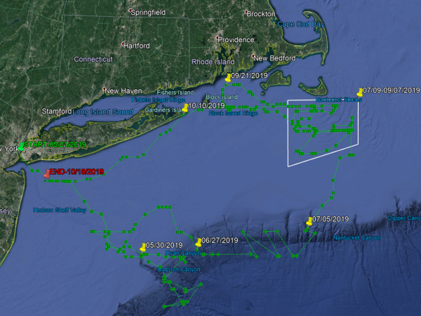
“I grew up there, we used to play around in the flume,” he said.The $5,000 satellite tag that washed up along that legendary striper hotspot at the Jersey Shore began its transmission on October 19 after popping free of the striper named Freedom; three days later, it was clanging around inside Dello’s coffee can. In early November, that tag was in the hands of researchers who’ve been diligently working to analyze millions of data points stored inside, telling the tale of a 42-inch striped bass caught and released from a Fin Chasers charter on May 21 in the lower Hudson River. Where she traveled in those 152 days, and how far she went, may surprise every striper fisherman and scientist along the entire Striper Coast, north, south, and east of Asbury Park.Suffice to say, this striper was born to run.

GREETINGS FROM THE HUDSON

The Northeast Striped Bass Study kicked off on May 21, 2019 when a team comprised of staff from The FishermanNavionics and Gray FishTag Research set upon New York Harbor to deploy a pair of satellite tags in post-spawn striped bass for a five-month study. The first large striper to get fixed with a satellite tag, aptly named Liberty, was caught aboard Rocket Charters out of New York City on the East River with Capt. Paul Risi. It was considered finding a “needle in a haystack” when the first tag washed up along the beach in Massachusetts back in the summer and was picked up by a woman walking the beach; check out the amazing results of that tag right here!

The second tagged fish, Freedom, was caught a little west of the first fish on May 21, not far from the Statue of Liberty aboard the charter boat Fin Chasers with captains Frank Wagenhoffer and Dave Rooney. The timing and location of the catch, tag and release project was planned around the end of the Hudson River spawning in hopes of capturing a pair of post-spawn bass; at 42 inches in length, Freedom was precisely the fish we were looking for!On December 5 at a conference at Gray FishTag Research in Florida, we learned the surprising truth behind Freedom. After being tagged in the lower Hudson River on May 21, data show Freedom heading in a southeast direction above the Hudson Shelf Valley, making it to the westernmost tip of the Hudson Canyon just inside the Babylon Valley – a distance of roughly 100 miles – for the Memorial Day weekend.

The information collected inside that Wildlife Computers MiniPAT tag reveals that Freedom spent the next month moving out and about within 20 or so nautical miles of that point, eventually zigzagging her way through Block Canyon out towards Veatch Canyon before heading north towards Nantucket Shoals in early July.

The beauty of these high-tech tags is that they incorporate light-based geolocation for tracking, time-at-depth histograms for measuring diving behavior, and a profile of depth and temperature. Some had questioned whether a larger predator like a white shark consumed the fish before making a beeline offshore; the data stored inside however show that both tagged fish were alive and swimming the entire time at sea.

NEW ENGLAND BOUND

Freedom spent the better part of July and all of August covering ground on the shoals outside of Massachusetts state waters, before heading northwest into Rhode Island Sound in what appears from the data points to be a somewhat circular pattern before cruising past Block Island to pay a visit to Montauk in early October.

For inshore fishermen and surfcasters in particular, Freedom didn’t make herself too available for capture for very long, ultimately sticking to the Exclusive Economic Zone (EEZ) for travel purposes, finally intersecting with her original May track out of the Hudson River in early October, before the tag disengaged pretty much on schedule east of Sandy Hook, NJ on Friday, October 18, just as the crew from The Fisherman was compiling our fishing reports for the November edition.

According to the tag data, a striped bass named “Freedom” spent much of her summer in the deep waters off Southern New England.

“Our predictions of a big bass attack this past week were right on the money,” reported North Jersey field editor JB Kasper that weekend. Sifting through our weekly reports at the time, it shows we had a pretty good nor’easter around that time, with a mid-week storm pushing wind and waves along the coast until that weekend. “When boats got back on the water on Saturday the 19th the stripers were still there and a flotilla of boats found mixed results,” Kasper noted in his New Jersey edition reports for the weekend, adding “Some of the best fishing was just inside the three mile line on Saturday.

”There’s no telling if Freedom made it past the “flotilla” of New York and New Jersey anglers on the grounds that week, but she did also have one of Gray’s green spaghetti tags affixed around her dorsal – as did Liberty – so there’s still a chance to learn more about both of these fish again in the future. One could roughly assume that Freedom enjoyed a bit of heavy feeding on bunker schools in the region before turning south along the three mile line with the rest of those big fish that anglers were finding off the Virginia coast as of early December. But as we’ve learned from the first two tags, our historic presumptions on striped bass migration might be off by as much as a few hundred miles.

According to the MiniPSAT data, Freedom spent much of the summer at depths of 50 to 75 feet, occasionally traveling to depths of between 150 and 200 feet.

“The science doesn’t always bear out the assumptions,” noted Dave Bulthuis, president of Pure Fishing’s North America division while sitting at the December 5 conference held by Gray FishTag in Lighthouse Point, FL. As one of the Advisory Board Members at Gray, Bulthuis and others spoke at length during the session about the need to provide better, more improved data for researchers managing coastal fisheries.

Dobbelaer stressed the ongoing goal “to get the data we desperately need,” while outlining for the group of advisors the urgency for better, more technologically advanced information. “This striped bass study reflects the movement of two fish caught and released in the Hudson River mouth and draws no conclusion of all striped bass behavior,” Dobbelaer said, adding “however, this groundbreaking movement lets us know that further work is a necessity from the team at Gray FishTag Research. There is so much more research that needs to be done to study the current patters and movements of striped bass.”In other words, if one is an anomaly, and two is a coincidence, it could take three or more high-tech satellite tags to help determine actual patterns.

CRITICAL BUY-IN

Another exciting bit of news learned at the Gray FishTag Research Advisory Board meeting in Florida on December 6 was that NOAA Fisheries is already actively engaged in the satellite tagging efforts. Eric Orbesen, Research Fishery Biologist with the fisheries agency and a specialist in highly migratory species and spatial movement is has worked with Gray FishTag Research professionals in ongoing swordfish research. Orbesen works out of NOAA’s Southeast Fisheries Science Center in Miami, but his ongoing participation in Gray tagging programs could be a good intro to other NOAA efforts with striped bass out of the Northeast Fisheries Science Center, which manages marine resources from the Gulf of Maine to Cape Hatteras.“Our goal is to continue to satellite tag many more striped bass in the Hudson River mouth during the same time of year in an effort to control the data collected on these great fish,” Dobbelaer told the folks assembled at the Florida conference. In fact, based on the early success of this groundbreaking work with striped bass, a new “spaghetti tag” project has also been launched with bull redfish in Northeast Florida where proceeds from the Full of Bull Tournament out of Jacksonville have been used to purchase 100 tag sticks and 1,000 streamer tags along with promotional materials as part of an education program there.

Closer to home for striper fishermen, funding efforts for new Wildlife Computers MiniPSAT devices for the ongoing Northeast Striped Bass Study have kicked into high gear. The 2019 study was funded by the charting professionals at Navionics, which has already signed on again for 2020. The Recreational Fishing Alliance (RFA) through its Fisheries Conservation Trust is also sponsoring a tag in 2020 utilizing monies raised through the annual Manhattan Cup catch and release striped bass tournament. Also kicking off during the holiday season was a new fundraising effort here at The Fisherman Magazine that seeks to find a core group of 1,000 individual investors to participate in the program.

For every $10 donation online, each “investor” will receive an exclusive Release, Reduce & Rebuild sticker to boast their participation in the tagging effort with their names added to an online list at TheFisherman.com. In just the first week of the fundraising, the effort raised $1,200 towards the purchase of additional Wildlife Computers MiniPSAT tags, which are valued at roughly $5,000 apiece. The initial promotional boost has also led to new pledges from within the recreational fishing community; looking ahead to the next round of tag deployments sometime this spring, it’s entirely possible that we have six or seven post-spawn stripers swimming around with pricey MiniPSAT devices next summer.

Whiteoak Tree History

Joyce Kilmer said he would never see a poem as lovely as a tree, and he was right.  Did he ever consider the value of a tree beyond its beauty?  A tree’s beauty is much more than bark deep.  


Sitting on my deer stand on the ridge overlooking Buck Creek, I am near a huge whiteoak farther along the ridge. I often look at that tree as it goes through changes from early fall to winter and consider what the tree has seen over its lifetime.


The big whiteoak is about 40 inches in diameter, giving it an estimated age of 300 years.  And whiteoaks can live to be 600 years old, so it is just middle aged!  It was standing full-grown on that hillside long before I was born and could be standing there long after I am gone.


In the way back time machine of my mind, I imagine a squirrel burying an acorn on that ridge in the fall 300 years ago, then not being able to find it during the winter.  That spring, a small twig pokes out if the ground and two tiny leaves sprout from it.  It is dwarfed by the grown oaks and other trees living there.


The twig slowly grows, getting taller with the passing years.  When about 20 feet high, a bluejay builds its nest in the fork of a limb.  Many more bird and squirrel nests will decorate the limbs of this tree as it becomes the giant old man of the area over the next 200 years.


During that time, the strong limbs and trunk protect the nests in storms that the tree weathers. Although other trees on the ridge get hit by lightning and killed, somehow the big one avoids this fate.  And its spreading roots hold it in the wind and bring in enough water that it survives droughts that kill others nearby.  It lives by taking water they need, but that is nature.


When the whiteoak is 20 years old and 25 feet tall something wonderous happens in May. Small knots appear at the ends of last year’s branches while others grow at the tips of new branches.  Those knots on old branches grow into green two-inch-long fuzzy stings that produce pollen.  The female ones on the new branches become tiny eight of an inch-long greenish red flowers.


After pollination, a bud starts to grow.  By fall it is an acorn an inch long.  The tree has only a few dozen this year, but by the time it is fifty years old it is producing thousands of acorns every year.  The acorns come in three to five-year cycles, with best years producing up to 10,000 from our tree but only a few hundred at the bottom of the cycle.


Those acorns control wildlife numbers. In abundant years whitetails store up plenty of fat to survive the winter. Squirrels bury many more than they will need during the winter, and other animals and birds find and eat them.  In lean years deer starve during the winter without their fat reserves and many birds and animals do not survive.  Whiteoak acorns are the manna of the woods and many depend on it.


When the tree was young, I imagine a Native American sitting on the big rock a few feet from the tree, patiently knapping a piece of flint.  I have found some of his failed efforts by the rock. The females of his tribe gather the acorns, grind them up and boil them, making a kind of acorn meal that sustains the group.


Based on the size of the trees growing on the flat areas, about 100 years ago a farmer cleared and terraced this hillside.  The remains of his small house sit at the top of the hill, up the long gentle slope from the sharp drop on ridge at the creek.


He and his family slowly and painstakingly cut trees, dug up stumps, move rocks and flattened areas to create bands on the hillside to grow crops.  The rocks were moved to the terraces he created between the flat areas, the remains of them are piled ever fifty feet or so.  This ground was very rocky and not very fertile.  


Based on that and the size of the house remains, he was probably a poor farmer with a family that did all the work.  They managed to scratch out a living, growing most of the food they ate and a small cash crop to buy the necessities.   


And they depended on wildlife from the woods and fish from Buck Creek for much of their protein.  I imagine one of them sitting under the big oak, hoping to “bark” a squirrel with his muzzleloader or, even better, shoot one of the rare whitetails. 


The big oak survived their axes, probably because of its size and location. Smaller trees up the slope were easier to get to the fireplace, and the big one right on the ridge did not interfere with their crops.


The whiteoak continues its life cycle, taking in water, carbon dioxide and sunlight during the day to produce oxygen, acorns, leaves and wood.  The falling leaves decay and fertilize the ground around the tree for other plants. And its roots hold the soil, preventing erosion.


At some point the mighty tree will fall, its life ended by lightning, drought or old age. Its trunk lying on the ground will provide hiding places for all kinds of bugs, as well as food for them.  It will slowly rot away, leaving its final nutrients in the ground where it fell.


In the way forward time machine in my mind, I see a squirrel burying an acorn from a nearby oak, probably the offspring of the fallen giant, in the rich soil where the big oak died, starting the cycle all over again.

Keeping Florida Fish Alive


Keeping Florida Fish Alive as Temperatures Drop
With temperatures dropping, can you handle the fish?

While many anglers sing the praises of Florida’s warmer fishing months, seasoned anglers know that winter can offer great fishing opportunities for some of the state’s most sought-after fish species. As the temperatures drop, you’ll spot many anglers, including veteran kayak angler Stephen Stubbs, following spotted seatrout to fresher water, where the fish congregate in large schools.

While this can make spotted seatrout an easy target, this species is also especially vulnerable to fatigue and exposure, so as the winter bite turns on, it’s important to use proper gear and fish handling techniques. This ensures the best chance of survival for released fish. Read on for some tips to help you handle the fishing as the weather cools down and the action heats up.

Prepping for the Day A successful day of fishing begins with preparation. Be aware of the area you will be fishing and local fish you might catch. Know the regulations for your target species and make sure you have all the proper gear. Determining ahead of time which fish you are going to keep versus which fish you will release is an easy step to take and something that Stubbs practices regularly.“My friends and I tend to harvest only slot trout under 19 inches to keep the more productive egg-layers (20 inches and over) in the water to continue the sustainability of this wonderful species,” Stubbs said.

Knowing which fish he plans to release helps to get those fish back in the water quickly, increasing survival and benefitting the fish population.

Some great gear to have in your stash is:

Barbless circle hooks – Are 90% more likely to hook a fish in the mouth. Hooking a fish in the mouth reduces internal harm and decreases dehooking time, getting the fish back in the water faster and increasing its chance of survival.

Dehooking tool – Allows anglers to quickly release their catch while minimizing injuries and handling time.

Correct weight tackle – Using tackle heavy enough to land a fish quickly is important so fish are less exhausted and more able to avoid predators upon release.

Knotless, rubber-coated net – These support the weight of the fish while removing a minimal amount of slime, which protects the fish from infection.

Fish On!Make sure to reel the fish in as quickly as possible. According to Stubbs, the key to landing a nice trout, especially a big one, is to manage the drag tension. Horsing a trout into the boat can usually result in additional tearing of the area they are hooked, especially around the mouth. It can also cause you to lose the fish. Work them in as they tire and keep tension on the line to prevent a hook release. Playing the fish too much can result in an exhausted fish that cannot avoid predators once released.

Landing the FishStubbs reminds anglers to always use a net for landing medium-to-large trout and dip/wet any measuring board with water before laying the fish on the board. That helps reduce the loss of slime and scales. Once you’ve got your catch to the boat, use these additional tips to ensure that fish are landed quickly and safely for the best outcome for both the angler and the fish.

Avoid removing large fish from water. If you must remove them, support their weight horizontally to prevent damage to their internal organs.

Take pictures of your catch while it is in the water. This puts less stress on the fish and the fish will look bigger.If a net is needed to land or control a fish, always use a knotless, rubber-coated landing net. Fish Handling Using the correct methods to handle your fish once you’ve landed them is important to ensure that released fish are in prime condition when returned to the water.

Return the fish to the water as quickly as possible. One of the major factors in the survival of a released fish is how much time it spends out of the water. The more fish that survive upon release today, the more fish there will be available to catch tomorrow.Wet your hands before handling a fish to prevent damaging its protective slime coating.

Don’t use gloves or towels, as this will remove the protective slime.
Never hold a fish by the gill cover or eyes.

Hold fish horizontally to support their internal organs.

Gripping devices can be effective for controlling and handling fish, especially ones with sharp teeth. Grip behind the lower lip and support the weight of the fish in a horizontal position.

Removing the Hook Removing a hook can be tricky. Use these tips to get the hook out and protect your trout (and other catches).If possible, keep the fish in the water while removing the hook.If the fish has swallowed the hook, cut the line as close to the hook as possible. Attempting to remove the hook can do more harm than good. Use non-stainless-steel hooks since they eventually dissolve or pass naturally.

Using a dehooking tool will allow you to remove hooks safely and quickly without touching the fish, giving it a better chance to survive. 

Releasing and RevivingTaking steps to return fish to the water properly can be a significant factor in their survival. With a little extra effort, you can give your fish a fighting chance at survival to reproduce and fight another day.

Place the fish in the water and allow it to swim away on its own; do not toss the fish back.

Revive fish that do not swim away immediately or appear lethargic.Place fish in the water head first – it is easiest to hold one hand on the bottom lip or tail and one hand under the belly of the fish.Move the fish forward in the water – this allows the water to be flow through the mouth and over the gills. The fish must face the direction of water flow.Use a figure-8 motion to move the fish forward constantly, ensuring water continues to flow over the gills. Never jerk fish back and forth, since this action prevents water from properly flowing through the gills.For fish caught in deep water with signs of barotrauma, use a descending device to return fish to depth or vent the fish by inserting a sharpened, hollow tube at a 45-degree angle, one inch behind the base of the pectoral fin.

Practice C-P-R: Catch-Photo-Release. Quickly land your fish, have a friend snap a quick photo during the action and return fish to the water expediently. Then submit your photos on com to earn prizes for your fishing achievements!

Ensure Fish Survive to Help Populations Thrive!The steps you take on the water today can help positively impact the future of your Florida fish populations! Dropping temperatures don’t have to mean a drop in the survival of the fish you release. To learn more about proper catch-and-release techniques, visit MyFWC.com/FishHandling.

The quarterly Gone Coastal column is one of many ways that the Florida Fish and Wildlife Conservation Commission (FWC) Division of Marine Fisheries Management is helping recreational anglers understand complex saltwater regulations and learn more about saltwater fishing opportunities and issues in Florida. We are also available to answer questions by phone or email anytime, and we would love the opportunity to share information through in-person presentations with recreational or commercial fishing organizations.

To contact the FWC’s Regulatory Outreach subsection, call 850-487-0554 or email Saltwater@MyFWC.com.

Where and How to Catch Lake Seminole August Bass

August 2015 Seminole Bass
with Laura Ann Foshee

Hot August weather, grass and bass just go together on some lakes. Throwing a frog to grass beds and getting explosive strikes is just about the most thrilling way to fish. And Lake Seminole is one of the best lakes anywhere to fish grass beds. Even better, right now Seminole is at the top of its cycle with lots of quality bass feeding in the lake.


Seminole is a big Corps of Engineers lake in the corner of Georgia, Alabama and Florida. Formed by a dam on the Apalachicola River just downstream of where the Flint and Chattahoochee Rivers join, it is very shallow and full of a variety of kinds of grass that form thick beds that bass love.

    Laura Ann Foshee is a rising senior at Gardendale High School near Birmingham.  She fishes with the high school team there and they fish both the FLW High School Trail and the BASS High School Trail.  They are also in the Alabama Student Angler Bass Fishing Association.  She does well with the team, finishing second in both the FLW State Championship and the TBF open which qualified me for the SEC Championship in September on Lake Lanier.  She also fishes some local pot and charity tournaments.

Laura Ann’s uncle is Scott Montgomery, owner of Big Bite Baits. He got her excited about fishing when he took her with him practicing for a tournament and she caught a big bass. He and members of the Big Bite Baits Pro Staff have taught her a lot about fishing. She also raises money for the Outdoor Ability Foundation and Pink Fishing, two charities that she cares deeply about.


She received the highest honor any high school fisherman can get this year when she was named as one of the 12 members of the BASS All American High School Bass Team, and is the only female angler to make the team this year.


By late July bass at Seminole are well into their summer pattern, setting up on ledges in deeper water. At Seminole, many of these ledges come up to a shallow grass bed where they move in to feed. Some bass will move back to deeper water after feeding, usually early in the morning and late in the day when light levels are low, but others will stay in the heavy grass shade and feed all day.


A variety of baits will catch those feeding bass. Early in the morning a popping frog, buzz bait or walking bait will get hit on top. Those baits will work later in the day if there is cloud cover. Some wind just rippling the water helps, too, as does current moving down the lake.


On brighter days a Sugar Cane eight inch paddle tail worm or Fighting Frog swam right at the top of the grass will catch them. A big Texas rigged worm like the Kriet Tail ten inch worm is good to work through the grass. And punching the mats with a Texas rigged Fighting Frog is also a good way to get bites from big bass, especially on calm, sunny days.


In late June Laura Ann and fellow Big Bite Pro Staff member Matt Baty from Bainbridge showed me how to catch these bass. First thing that morning Laura Ann caught a five pounder on a Spro popping frog and she and Matt also missed some big bites as well as catching several keeper bass. Then, just before we left, another five pounder hit a swimming Fighting Frog.


The following ten spots had bass on them when we fished and will be even better now. They are in the order we fished them, leaving Wingates Lunker Lodge and working downstream, then going up the Flint River and working back down to Wingates.

1N 30 45.844 – W 84 46.235 – If you put in at Wingates you can run the flat downstream without going all the way to the channel if you are careful. The channel is on the opposite side of the Flint River across from Wingates but swings across the lake and comes close to the south bank at red channel marker 8.8.


Go to it and you will see a good grass line running from the channel marker upstream. Start there or on the upper end of it in front of a house sitting up on the ridge with a dock in front of it. This house has a cleared bank in front of it and the dock is the first of four docks fairly close together.


Keep your boat in 10 to 12 feet of water out from the grass line and cast a popping frog into the grass and work it out. Laura Ann expects the bass to be swimming the grass line and feeding, so she works her frog from the grass to the edge and pauses it for a beat, expecting a reaction bite when the frog clears the grass. This is how she caught the five pounder here.

2 N 30 46.314 – W 84 46.086 – Follow the channel upstream across to the opposite bank. Near the bank just downstream of the black channel marker where the channel comes to the bank there is a small island. Go to the upstream end of this island and start fishing the grass line working upstream. This is the Fort Scott Island area.
The channel edge here has rocks that hold a lot of bass and the grass itself has points, cuts and ditches in it the bass use for ambush points. Cast your frog into the grass. You can also cast a buzzbait or walking bait to the edge of the grass and into cuts in it.


Laura Ann likes a Strike King half-ounce white buzz bait and a bone Spook for fishing the more open water over the submerged grass. Another effective way to get bit is to cast these baits across the ends of points of grass that stick out from the main bed. A very good one is near the channel marker as you work upstream from the island. We got a good keeper bass here.

3 N 30 46.163 – W 84 46.995 – Going downstream past the small island a big bay opens on your right. This is Carl’s Pass where you can go between the islands all the way to Spring Creek when the grass is not too thick. A channel comes out of the middle of this bay and turns and goes downstream to come back in near the bank at the downstream end of the bay.


Bass use this ditch to move in and out and feed along the grass lines on it. Keep your boat in the ditch in about six feet of water and fish the grass with topwater. Laura Ann likes a white frog first thing in the morning since bass are usually feeding on shad, but later in the day she will switch to a more natural color frog since the bass are usually feeding on bluegill then.


If you have a good GPS with a good map chip you can see this ditch and follow it. If not stay out from the visible grass and work from the middle of the cove toward the downstream side of it, fishing the grass edges and changes in it. A keeper bass hit a buzzbait here when we fished.

4 N 30 45.181 – W 84 50.577 – River Junction Access is a boat ramp on the south bank near where it turns toward the dam. Go down to it and stop well out in front of it at the pole marker showing the channel in to the ramp. There is a small number 508 on this marker.


If you leave hole number 3 you can follow the north bank down and hit the channel markers coming out of Spring Creek, or go back upstream and follow the markers from hole number 2, but there is standing timber in the middle of the open water between the north bank and the river channel, so it is not a good idea to go straight across.


The green marker pole is on a small hump just off the river channel that has a good grass bed on it. Keep your boat in 10 feet of water and fish all the way around it. The points on either end are usually best, especially if there is any current moving down the river.


Fish topwater on this hump, especially if you are there early in the morning or late in the day, or if cloud cover keeps the light low. A light breeze rippling the water helps, too. So the best time to fish grass beds is a hazy to cloudy day with a slight breeze just rippling the water.

5 N 30 45.554 – W 84 47.555 – Go back up the river to red channel marker 7.4. The grass line along the drop here is good so fish both sides of the marker along it. The grass is thick from this edge all the way to the bank and you can get in the grass and punch through it with a Fighting Frog behind a one to one and a half ounce tungsten sinker.


For a different look Laura Ann also likes to punch mats with a Big Bite Tube on the same rig. Drop your bait so it falls through the grass to the bottom and be ready to set the hook if you feel anything different, like it feels a little heavy.


If you are fishing near the time of a full moon another pattern can often catch big bass and this is a good place to try it. Go into the bank. You can punch the mats as you work in. When you get a long cast from the bank, throw a Spro bream colored popping frog to the bank. If the bream are bedding some big bass will often be hanging around the bream beds and hit it.

6 N 30 47.019 – W 84 43.648 – Upstream of Wingates a huge flat runs for a long way on the south bank. You can run this flat if the grass is not too thick. On the bank you can see some houses and docks, and Brocketts Slough is a big slough with a spring in it. Across from it the river makes a definite wide horseshoe bend to the north bank.


Stop way out from the mouth of the slough. Bass hold along the grass bed here along the seven foot contour line. Follow this grass line for about 200 yards, keeping your boat in eight or more feet of water and cast to it. Try topwater as well as punching the mat here. Fish any changes in the grass that will give the bass a holding and feeding spot. Points, cuts and holes are all good.

7 N 30 47.227 – W 84 42.883 – If you go upstream on the flat the grass will be very thick, possibly too thick to run. But if you do you will see a small gap ahead of you near a red channel marker where the river swings back across the lake on the upstream side of the horseshoe bend. The gap is where boats cut through to run the flat so there is a channel in the grass made by them.


The river channel is just off this grass bed at the gap and is a good place to fish. Current coming down the river hits it and it drops off fast. Stay in the channel and fish the grass with all your baits.
When boats come by and cut through the grass line, don’t get mad, just fish behind them. Their props and wakes disturb the baitfish in the grass and make them move and that will often turn on the bass and make them feed. Fish all around the cut when a boat goes through it.

8 N 30 47.365 – W 84 41.753 – From the bend in hole 7 the channel runs fairly straight up to Butlers Creek as it narrows down. On your right, out from the creek mouth, the grass forms a point running downstream. The creek channel comes in and turns downstream to join the river channel and the point of grass is an excellent feeding spot. There is always some current here due to the narrow area and that makes it better.

Fish the point of grass on the river side and on the creek side. Start with your boat in the channel and fish the outside edge, working along the point until the grass ends. Then move in and fish the grass line on the inside, following it as it curves toward the mouth of the creek. Try topwater and punching the mat. But also swim a paddle tail worm or Fighting Frog over the submerged grass and through any openings in it.

Rig your Fighting Frog behind a one quarter ounce tungsten weight Texas rigged. Keep it down so it bumps grass as you swim it along. If it hangs up on the grass jerk it loose and keep it moving. Bass will suck it in as it swims along so be ready to set the hook if your rod loads up at all.

9 N 30 47.327 – W 84 43.967 – Go downstream to red channel marker 12.6. A good grass line runs along the channel edge between this marker and marker 12.5. Start at either marker and fish all along the grass between the two. Keep your boat in the channel and cast to the grass with all your baits.
Laura Ann uses Sunline FX2 Braid for fishing grass since the bass will bury in it. Fifty to sixty pound test works well.


And she fishes it on Lews Tournament Lite Reels and custom rods wrapped by TigeRodz with Rainshadow Revelation & Eternity rod blanks to suit her different kinds of fishing.
.

10 N 30 46.318 – W 84 45.291 – Go down to the entrance to Wingates. There are three double sets of poles marking the channel in to it. Stop at the middle set of poles and fish all the grass around it. A ditch goes both ways from this set of poles and fish feed along it, and it is restocked with tournament released fish at Wingates.


The other five pounder hit a Fighting Frog swam along the top of the grass here. Try it and topwater, too. But also work a big Texas rigged worm through the grass. Laura Ann likes the green pumpkin ten inch Kreit Tail worm with a chartreuse tail. A light tungsten sinker, one quarter ounce or lighter, will make your worm come through the grass better. Move it along with pauses and let it fall into holes in the grass.


All these places hold bass right now and there are a lot of quality bass from four to six pounds on them. Give them a try and you can see the types of grass to fish and find many more similar grass beds all over the lake.
You can keep up with Laura Ann’s fishing by following her on Facebook and Twitter at lauraannfoshee or on Instagram at Foshizal_Fo_Sho.

Tarpon Tagging Program Yields Results

Tracking

Bonefish and Tarpon Trust Tarpon Tagging Program Yields Results
It’s hoped the 5-year acoustic tagging program will help answer many questions about tarpon movements around Florida’s coasts.

The Tarpon Acoustic Tagging Project is a collaborative, five-year program designed to broaden our understanding of tarpon movement and habitat uses. The results will help shape future conservation measures, including the protection of critical habitats and improvements to fishing regulations.  The project is generously sponsored by Maverick Boat Group.

Tarpon Acoustic Tagging is addressing the following questions:

Is the tarpon population large and robust or small and vulnerable? If anglers in a particular location are fishing for the same fish every year, then the tarpon population is probably smaller than we think, and issues like shark predation will become a bigger concern. If fish move among regions every year, and anglers are fishing for different fish each year, the tarpon population is probably relatively large.

Do tarpon gather in the same areas for spawning each year or move among areas? On average, ocean currents will carry the larvae from a spawning site to juvenile habitats in a specific geographic region. If it’s the same adults at the spawning site every year, then local adult losses will cause local declines in juveniles. If tarpon move among spawning sites, then the population will be more resilient.

How do changes in freshwater flows into coastal waters influence tarpon movements? Do the problems with Lake Okeechobee and Everglades restoration impact tarpon? Are the water issues in Apalachicola causing changes in tarpon movements?

What are the movement patterns and habitat use of mid-size tarpon (20-50 pounds)? How will these tarpon be impacted by coastal water quality issues? This size class, which is the future of the fishery, is very vulnerable to changes in coastal habitats and water quality.Until the Tarpon Acoustic Tagging Project began, there was little information available to answer these questions. Satellite tagging provided spatial and temporal data that was limited to tarpon weighing 80 pounds and larger. After a few months, most satellite tags detached from the fish, making it difficult to study their movements over the important multi-year time frame. Acoustic telemetry has helped to combat these limitations.Why Acoustic Tagging?Acoustic tags provide the ability to track tarpon for five years. They are also small enough that they are being used on tarpon as small as 5 and as large as 200 pounds!

Acoustic telemetry has helped to broaden the scope of tarpon research. When deployed, a tag is surgically implanted in the fish’s abdomen before safe release. The tagged fish swims within range of an underwater receiver, which detects and stores the tag’s unique code. BTT and collaborators have approximately 100 receivers deployed, but we are also able to take advantage of the network of receivers being used by collaborators studying everything from redfish to sawfish. This vast network exceeds 4,000 receivers deployed from Chesapeake Bay to the Gulf of Mexico. As scientists detect tagged fish on their receiver networks they share data with other scientists, effectively expanding the study area.

All years are concurrently playing with the date displayed in the upper left corner. The movements shown here are represented “as the crow flies”, thus the movement tracks may cross land.

How You Can Help

Sponsor a Tarpon: Sponsor an acoustic tag for $3,000. You can name your tarpon and will receive a certificate with its name and initial capture info (general location and measurements).  Sponsors will receive access to a password protected site where they can see periodic updates of their tarpon’s movements.

Sponsor a Receiver: Sponsor and name an acoustic receiver (listening station) for $3,000.  Sponsors will receive periodic reports summarizing the tarpon detections it has recorded.

Help us tag tarpon: Prior to every tagging trip, our team of scientists will notify sponsors  about when and where they will be working, along with contact information. If you are fishing in that area on tagging dates, all you need to do is call us when you catch a tarpon. We’ll come to your boat, transfer the tarpon to our sling, and take implant a transmitter. Remember to always keep the tarpon in the water!

Contact Us Today! For more information and to sponsor a tag or receiver, please contact Mark Rehbein, Director of Development at 703-350-9195 or mark@bonefishtarpontrust.org

Where and How To Catch July Lake Hartwell Bass

July 2015 Lake Hartwell Bass
with Trad Whaley

Hate the heat of July? Think it is too hot to go fishing? You should plan a trip to Lake Hartwell and enjoy catching quality fish on topwater plugs to make you forget how hot it is!


Lake Hartwell is a big Corps of Engineers lake on the Savannah River. The lower lake is full of long points, humps, standing timber and brush piles. Blueback herring are a favorite food of the bass in the lake, making them grow to good average sizes and making the bass feed on specific patterns this month.


The water on the big water is very clear and topwater plugs draw bass from the depths to smash them. Bluebacks tend to come to the surface on sunny days so the bass’s attention is focused toward the top, so surface activity is attractive to them. That combination insures good topwater fishing all month.


Trad Whaley lives in Abbyville, South Carolina and has fished Hartwell all his life. Although he has not been fishing a lot of tournaments lately he is well known in the area on the tournament trails. His father Danny is also a well-known tournament fisherman and taught Trad a lot about catching bass on Hartwell.


When he was just eight years old Trad started fishing team tournaments with his father and learned how to catch fish in competition. It paid off. Trad has won two BFLs on Hartwell and placed seventh in an FLW series tournament there. He also won many local tournaments over the years.

Right now Trad is concentrating on helping kids learn to catch bass. He is one of the coaches for the Abbyville High School Team and his nephew, Carter McNeil, who Trad taught about fishing, is one of the 12 students on the BASS High School All American Team this year. And Trad’s daughter Caelyn is a good bass fisherman winning tournaments although she just finished Middle School this year.


For July Trad relies on a small selection of lures. He will have a top-water walking bait like a Spook or Sammy, a top water popper, a frog, a wobble head jig and a Fluke ready for fishing near or on the surface. And he always keeps a drop shot worm ready for casting or dropping down to fish or brush piles he sees on his depthfinder.


“In July bass on Hartwell are on main lake structure feeding on herring,” Trad says. They will school on top in the morning then move to brush piles when the sun gets high. They will still come up to hit a bait fished over the brush even in the bright sun.


We fished Hartwell in mid-June and the bass were feeding. In just a few hours we caught or lost four or five bass in the four pound range and several more not much smaller. The following ten spots were holding bass then and will have even bigger schools on them now.

1 N 34 20.745 – W 82 49.680 – If you put in near the dam at daylight go to the riprap on the Georgia side of the lake. A small island sits off the riprap and the gap between the island and the riprap focuses any current and bass feed on herring on the rocks and the shallows around the island on top before the sun gets on the water


Bait is the key here and on other places. Trad asked me if I could smell the herring as we idled to the rocks to start out day. That is one way to know they are in the area. You can also see them on your depthfinder or, hopefully, see bass chasing them on top before the sun gets bright.


Fish the rocks and the shallows near the island with your Spook or Sammy. Always keep close watch for anything on the surface and cast to it. Make long casts, the bass are often spooky in the clear water. Walk your bait fast back to the boat and fan cast the area if you are not seeing surface movement.

2 N 34 20.752 – W 82 50.300 – Watsadlers ramp sits on the point on the north side of the first pocket at the dam on the Georgia side. A series of humps run off this point and there are shoal markers on some of them. Trad starts on the big flat between the ramp and the first shoal marker and fishes out to the humps marked by two shoal buoys.


Again start with a walking bait and watch for surface activity. Bass will scatter in the shallow water and chase herring before the sun gets bright, then move to brush piles on the humps. If you watch your depthfinder you will find many brush piles on every hump. In fact, there are so many it is often hard to fish them all.


Trad likes the Sammy 100 in chrome or similar colored Spook. He will also cast a Zoom white or transparent Fluke to surface feeding fish or fan cast it in these areas early. Sometimes the bass want something worked just under the surface and a Fluke is perfect for this. Make long cast with it and fish it back fast with a lot of action.

3 N 34 22.816 – W 82 50.602 – Powder Bag Creek is the first big creek north of the dam on the Georgia side. The upstream point of it runs way out and Long Point ramp is on it. Out from the downstream edge of this big point are three shoal markers forming a triangle. Line up the two just upstream of the one downstream and stop on the hump that comes up to 16 feet on top. You will be straight out toward the middle of the lake from the point and markers.


Fish all around the hump with topwater and Fluke, keeping your boat in 25 to 30 feet of water and casting to the top of the hump. This hump has a hard bottom like the others marked and that makes them better, but the brush piles on them are more important so keep a close watch for them as you fish.


If you find brush piles mark their location to fish over them. Bass concentrate around and over the brush even at first light and roam from there, so they are hotspots all day. If you get right on top of one before seeing it, remember where it is to fish later in the day.

4 N 34 23.138 – W 82 50.430 – Channel marker 7 sits upstream and out from hole 3. Upstream from it, out right on the river channel, a danger marker with “Danger Tree” on it marks standing timber on the edge of a hump. The trees, hump and brush piles on it make an ideal place for bass this time of year.


Keep your boat near the marker in 25 feet of water and cast over the trees and the hump. Work a topwater bait over them. Bass will school here but will also come out of the trees and brush to hit on top when the sun is up.
Some wind blowing across this spot and others makes it better. Trad says the perfect day is when the sun is fairly bright and the wind is making the water ripple. If the waves and ripples are big enough to make working the walking bait ineffective he will throw a popping bait like a Pop-R to make more noise to attract the fish.

5 N 34 23.076 – W 82 50.841 – Go back in toward the point just north of channel marker 9. There is a shoal marker on the upstream side of the big point behind it, the same point hole #3 is on the downstream side. Stop out upstream of the shoal marker in 25 feet of water and fan cast over it.
Trad will often idle in fast toward the hump here and in other places and stop before he gets to the 25 foot depth. He says the boat moving in will often push the schools of bait toward the hump or point and turn the bass on.


Fan cast all over the hump from the deeper upstream side. Trad got a solid four pounder here on his Spook and there were several more that size and bigger following it as he fought it to the boat. If two people are fishing it often pays off for the second person to cast to the fighting bass to catch followers.

6 N 34 23.238 – W 82 51.134 – West of hole 5 is the mouth of Gum Branch. Go toward it and the big white house sitting on a point back in it a little ways. There is a marked hump with bushes on top of it just inside the big point. Stop out in 25 feet of water and fan cast all around the downstream side and end of it. I lost a four pounder that hit my topwater plug three times before taking it here.


Work topwater first but also try a wobble bait like a Pulse Jig with a Fluke on it. Sometimes, especially when the sun is higher or if the wind is fairly strong, the Pulse Jig will draw strikes better than the topwater. Make long casts, let it sink a little then reel it in slowly. When you feel weight just keep reeling until the rod loads up. Trad says if you set the hook as soon as you feel the fish you will miss it.

7 N 34 23.430 – W 82 51.321 – Toward the mouth of Gum Branch an island sits west of channel marker 11. A flat around it drops off into the channel and bass hold on it and feed. There are a couple of ditches on it and many brush piles. The island helps concentrate any current in this area.
Stop in 25 feet of water and fish the flat on the river side. Try topwater then a Fluke and a Pulse Jig. Watch for brush piles on your depthfinder and fish them with a drop shot when you see them. Trad caught several bass out of brush here but they were smaller and there were several spotted bass. He says you can catch keeper size bass all day by fishing brush with dropshot but they tend to be smaller than the fish you will catch on topwater.


Trad hits many places fast during a day of fishing. He will pull up on a place like this and do what he calls his 1 – 2 – 3 – 4 punch – topwater, Fluke, pulse jig then drop shot. He quickly fishes all four baits then moves on to the next spot. We hit about 15 places in four hours and he says that is not unusual.

8 N 34 24.408 – W 82 51.270 – Go across the mouth of Lightwood Log Creek to the islands on the upstream side of it. Stop on the island closest to the bank, between it and the one further out. A point comes off this island toward the outer island and fish hold on it and feed.


The two islands concentrate current here and current always makes these spots better. For that reason, week days are better fishing since there is less current during the weekend. Many fishermen have seen this change from week day practice to a weekend tournament.


Fish all your baits here. With the drop shot, Trad uses a fairly heavy three eights ounce sinker and puts a Zoom Meathead or Tiny Fluke about 18 inches above it. He drops it to the bottom around the brush and moves it very little, with light shakes of the rod tip to make the bait dance. He will also drop the bait down to suspended fish and hold it at their level, shaking it a little right in front of them.

9 N 34 25.669 – W 82 51.527 – Going upstream a small double creek enters on the Georgia side between channel markers 19 and 21. In the mouth of this creek, out even with the island downstream at Lightwood Log Creek and the upstream point of the double creek, is a hump that holds bass.


This hump is near the river channel and comes up to a feeding table. It has brush on it to fish. Keepyour boat in deep water and cast to the top of it all around it. Trad says be ready to follow up with a Fluke if a bass boils on your topwater plug but doesn’t take it. We had several fish hit up to three times before taking the plug the day we fished. Following up quickly with a Fluke will often catch a bass that misses the topwater.

10 N 34 26.692 – W 82 51.527 – There is a big island right at the mouth of the Tugaloo River on the left going upstream at channel marker T1. A point runs off this island toward the channel. It slopes off on one side with a sharper drop on the other and current moves across it making it a good feeding spot.


Keep your boat out in 25 feet of water and fish across the point with the current if it is moving. Trad says the key depth here and on all other places in July is 18 to 25 feet deep. Fish hold at that depth in brush so watch for brush in it, but fish over it, too.


All these places held fish a couple of weeks ago and are even better now. Try Trad’s baits and learn from these places for the kind of structure and cover you want to fish in July and you can find many more all over the lower lake.

Lionfish

Lionfish

Impacts of Invasive Lionfish
Lionfish are native to coral reefs in the tropical waters of the South Pacific and Indian Oceans. But you don’t have to travel halfway around the world to see them. This is an invasive species that threatens the well-being of coral reefs and other marine ecosystems, including the commercially and recreationally important fishes that depend on them.

NOAA and its partners are working hard to develop ways to prevent further spread and control existing populations.

Lionfish have become the poster child for invasive species issues in the western north Atlantic region. On par with zebra mussels, snakeheads, and even Asian carp in notoriety as invaders, lionfish populations continue to expand, threatening the well-being of coral reefs and other marine ecosystems, including the commercially and recreationally important fishes that depend on them. NOAA and its partners are working hard to develop ways to prevent further spread and control existing populations.

History The common name “lionfish” refers to two closely related and nearly indistinguishable species that are invasive in U.S. waters. Lionfish, which are native to the Indo-Pacific, were first detected along Florida coasts in the mid-1980s, but their populations have swelled dramatically in the past 15 years. Lionfish are popular with aquarists, so it is plausible that repeated escapes into the wild via aquarium releases are the cause for the invasion. Lionfish now inhabit reefs, wrecks, and other habitat types in the warm marine waters of the greater Atlantic.

Lionfish continue to expand at astonishing speeds and are harming native coral reef ecosystems in the Atlantic, Gulf of Mexico, and Caribbean. Biologists suspect that lionfish populations have not yet peaked in the Gulf of Mexico, which means that their demand for native prey will continue to increase. Recent research has also revealed that lionfish can tolerate brackish coastal zones, so mangrove and estuarine habitats may also be at risk of invasion.

Impacts to Native Fish and Coral reefs Adult lionfish are primarily fish-eaters and have very few predators outside of their home range. Researchers have discovered that a single lionfish residing on a coral reef can reduce recruitment of native reef fishes by 79 percent. Because lionfish feed on prey normally consumed by snappers, groupers, and other commercially important native species, their presence could negatively affect the well-being of valuable commercial and recreational fisheries.

As lionfish populations grow, they put additional stress on coral reefs already struggling from the effects of climate change, pollution, disease, overfishing, sedimentation, and other stressors that have led to the listing of seven coral species in the lionfish-infested area. For example, lionfish eat herbivores and herbivores eat algae from coral reefs. Without herbivores, algal growth goes unchecked, which can be detrimental to the health of coral reefs.

What’s Next? NOAA has created an Invasive Lionfish Web Portal—a clearinghouse for all things related to lionfish outreach and education, research, monitoring, and management. Interested parties will no longer need to browse through multiple web pages to find accurate information; it will be available in a centralized location.NOAA researcher and lionfish expert Dr. James Morris recently hosted the 7th annual lionfish symposium at the 2014 meeting of the Gulf and Caribbean Fisheries Institute in Barbados. More than 35 presentations were given on lionfish research around the region.

This meeting built upon the results of a 2013 GCFI lionfish workshop focused on harvesting invasive lionfish: An invasive lionfish food fish market is practical, feasible, and should be promoted.Alternative invasive lionfish end-uses, such as the curio and aquarium trade, are also viable markets.

Regarding consumption and the risk for ciguatera poisoning, invasive lionfish should not be treated differently than other tropical fish species and a general caution statement should be displayed within all establishments that serve fish and on all fish products.Local control is effective at minimizing invasive lionfish impacts at local scales and should be encouraged where possible.

Though no confirmed cases of ciguatera poisoning from eating lionfish have occurred, fears persist. A Caribbean-wide assessment of lionfish ciguatera levels is nearly complete and a report will be publicly available in the coming months. If lionfish are proven to be safe, and if cost-effective harvest and distribution mechanisms are developed, small-scale fishermen may be able to capitalize while simultaneously helping to control the invasion.

Cooperation and communication among local, state, federal, and international partners is crucial for proper management of lionfish and other widespread invasive species. Accordingly, a National Invasive Lionfish Prevention and Management Plan was developed by members of the Aquatic Nuisance Species Task Force—an intergovernmental organization co-chaired by NOAA. The plan will be publicly available in spring 2015 pending final review and approval. NOAA’s National Marine Sanctuaries Program is working to finalize their own lionfish plan that will guide the management of this invasive species in the affected sanctuaries in the Gulf and southeastern United States.

Together, these plans will guide the management of invasive lionfish and ensure that all are working toward common objectives.More information on NOAA’s lionfish research programs can be found online.An animated map of lionfish spread is available on the U.S. Geological Survey’s Nonindigenous Aquatic Species web page.